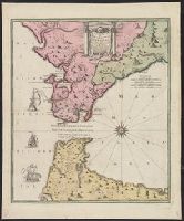
Belgium Catholicum seu decem provinciae Germaniae inferioris and Carte des Pais Bas catholiques où des X provinces de l'Allegmagne inférieure, etc. dessinée au juste selon les exactes observations astronomiques et opérations géometriques des Messur. Cass
Description:
"Avec privil. Imperial" above neat line.
Publisher:
Edentibus Homannianis heredib.,
Subject (Geographic):
Belgium--Maps--Early works to 1800. and Luxembourg--Maps--Early works to 1800.
Subject (Name):
Cassini, César-François, 1714-1784, Homann Erben (Firm), and Snellius, Willebrord, 1580-1626
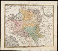
"La couleure violette marque les pays démembrés de la Pologne en 1772, conformément aux prétensions des trois Puissances voisines."--Lower left margin.
Publisher:
Luci publicae tradita per Homannianos Heredes
Subject (Geographic):
Belarus--Maps--Early works to 1800., Lithuania--Maps--Early works to 1800., Poland--Maps--Early works to 1800., and Ukraine--Maps--Early works to 1800.
Copy 1: Borders of lakes and frame of map colored in yellow. Backed with linen. Stamp: Thorne Collection of Cartography and Geography. Stamp: Karpinski-von Wieser Map Collection.
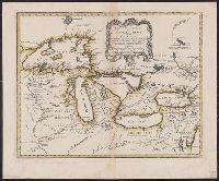
Publisher:
[Homann Erben?],
Subject (Geographic):
Canada--Maps--Early works to 1800, Great Lakes Region (North America)--Maps--Early works to 1800, and New France--Maps--Early works to 1800
Subject (Name):
Homann Erben (Firm) and Thorne Collection of Cartogaphy and Geography Stamp