Search
You Searched For
Search Results
- Creator:
- Horký, Karel, 1879-1965
Lenhard, J
- Published / Created:
- c1917.
- Call Number:
- 30 1917B
- Container / Volume:
- BRBL_00032A
- Image Count:
- 1
- Resource Type:
- Maps, Atlases & Globes
- Description:
- Caricature map.
- Publisher:
- s.n.],
- Subject (Geographic):
- Europe--Maps and Europe--Politics and government--Maps
- Subject (Topic):
- World War, 1914-1918--Maps
- Found in:
- Beinecke Rare Book and Manuscript Library > 1914--1915--1916--1917--?? / drawn by J. Lenhard.
- Published / Created:
- ca. 1880]
- Call Number:
- 30 1880A
- Container / Volume:
- BRBL_00032
- Image Count:
- 1
- Resource Type:
- Maps, Atlases & Globes
- Description:
- Ancillary text: A chave do enigma.
- Subject (Geographic):
- Europe--Maps
- Subject (Topic):
- Caricature--Europe--Maps and Russo-Turkish War, 1877-1878--Maps
- Found in:
- Beinecke Rare Book and Manuscript Library > A Europa em 1877 : mappa burlesco da guerra / por Abdul-Azis ; Livrarie Ferreira, editora ... ; Lith. Palhares ...
- Published / Created:
- [1941]
- Call Number:
- 36hc 1941A
- Container / Volume:
- BRBL_00134
- Image Count:
- 1
- Resource Type:
- Maps, Atlases & Globes
- Description:
- Includes inset of the Ruhr region.
- Publisher:
- Ministry of Information,
- Subject (Geographic):
- Europe--Maps
- Subject (Topic):
- World War, 1939-1945--Germany--Maps
- Found in:
- Beinecke Rare Book and Manuscript Library > Allied air offensive against Germany [cartographic material].
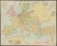
- Creator:
- G.W. Bacon & Co
- Published / Created:
- [ca. 1917]
- Call Number:
- 307hc 1917
- Container / Volume:
- BRBL_00036A
- Image Count:
- 2
- Resource Type:
- Maps, Atlases & Globes
- Description:
- Relief shown by hachures.
- Publisher:
- G.W. Bacon & Co.,
- Subject (Geographic):
- Europe--Maps and Europe--Politics and government--Maps
- Subject (Topic):
- World War, 1914-1918--Belgium--Maps, World War, 1914-1918--France--Maps, and World War, 1914-1918--North Sea--Maps
- Found in:
- Beinecke Rare Book and Manuscript Library > Bacon's map of the seat of war in the North Sea, Belgium and eastern France.
- Published / Created:
- 1920
- Call Number:
- 30fb 1920
- Container / Volume:
- BRBL_00037B
- Image Count:
- 2
- Resource Type:
- Maps, Atlases & Globes
- Publisher:
- John Bartholomew & Son Ltd.,
- Subject (Geographic):
- Europe--Maps
- Found in:
- Beinecke Rare Book and Manuscript Library > Bartholomew's Political Map of the New Europe 1920 / According to treaties of Paris showing the old states of 1914 and the new of 1920.
- Creator:
- John Bartholomew and Son
- Published / Created:
- [1916]
- Call Number:
- 30hcg 1916
- Container / Volume:
- BRBL_00038
- Image Count:
- 2
- Resource Type:
- Maps, Atlases & Globes
- Description:
- Includes 7 insets.
- Publisher:
- Edinburgh Geographic Institute,
- Subject (Geographic):
- Europe--Maps
- Subject (Topic):
- World War, 1914-1918--Europe--Maps
- Found in:
- Beinecke Rare Book and Manuscript Library > Bartholomew's general war map of Europe and the Mediterranean / John Bartholomew & Co.
- Creator:
- Edinburgh Geographical Institute
John Bartholomew & Co
- Published / Created:
- [1914]
- Call Number:
- 11hc 1914
- Container / Volume:
- BRBL_00010A
- Image Count:
- 2
- Resource Type:
- Maps, Atlases & Globes
- Description:
- Includes 7 inset maps.
- Publisher:
- Edinburgh Geographical Institute,
- Subject (Geographic):
- Europe--Maps and Mediterranean Region--Maps
- Found in:
- Beinecke Rare Book and Manuscript Library > Bartholomew's general war map of Europe and the Mediterranean [cartographic material] / John Bartholomew & Co.
- Creator:
- Edinburgh Geographical Institute
John Bartholomew and Son
- Published / Created:
- [1920]
- Call Number:
- 30 1920
- Container / Volume:
- BRBL_00032A
- Image Count:
- 2
- Resource Type:
- Maps, Atlases & Globes
- Publisher:
- John Bartholomew & Son, Ltd.,
- Subject (Geographic):
- Europe--Maps
- Found in:
- Beinecke Rare Book and Manuscript Library > Bartholomew's political map of the New Europe, 1920.
- Creator:
- Great Britain. Public Record Office
United States. Army. Corps, 12th
- Published / Created:
- 1945
- Call Number:
- 11hd 1945F
- Container / Volume:
- BRBL_00010ZF
- Image Count:
- 1
- Resource Type:
- Maps, Atlases & Globes
- Description:
- "Issued by PRO in cooperation with Corps engineers."
- Publisher:
- PRO,
- Subject (Geographic):
- Europe--Maps
- Subject (Name):
- United States.--Army.--Corps, 12th
- Subject (Topic):
- World War, 1939-1945--Campaigns--Europe
- Found in:
- Beinecke Rare Book and Manuscript Library > Battle route of the XII Corps in the European theater of operations [cartographic material].
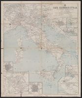
- Published / Created:
- [ca. 1920].
- Call Number:
- 40gme 1920
- Container / Volume:
- BRBL_00230
- Image Count:
- 2
- Resource Type:
- Maps, Atlases & Globes
- Alternative Title:
- Carta delle comunicazioni principale di Europa
- Description:
- Includes 8 insets.
- Publisher:
- Fratelli Pozzo,
- Subject (Geographic):
- Europe--Maps and Italy--Maps
- Subject (Topic):
- Railroads--Europe--Maps and Railroads--Italy--Maps
- Found in:
- Beinecke Rare Book and Manuscript Library > Carta ferroviaria d'Italia e linee di navigazione / Prof. Giovanni de Agostini e figli.