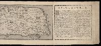
1.

- Creator:
- Berry, William, fl. 1669-1708
- Published / Created:
- [1689?]
- Call Number:
- 1973 Folio 10
- Image Count:
- 1
- Alternative Title:
- New map of the kingdome of England and Wales, New mapp of the kingdom of England and Dominion of Wales, and New map of the kingdom of England and Dominion of Wales
- Description:
- BEIN 1973 Folio 10: Imperfect: upper right of map mutilated, with some loss of text. Sheet measures 61.2 x 96.3 cm. Bookplate of José M. Rodriguez. No. 4 of 63 maps bound together.
- Publisher:
- Sold by William Berry at the sign of the Globe between Charing Cross and White Hall
- Subject (Geographic):
- Great Britain
- Subject (Topic):
- Roads
- Found in:
- Beinecke Rare Book and Manuscript Library > A new mapp of the kingdome of England and Wales : containing all the cities, market towns, with the roades from town to town, and the numbers of reputed miles between them, are given by inspection without scale or compass