Search
You Searched For
Search Results
- Creator:
- Reid, C. A
- Published / Created:
- 1911
- Call Number:
- 652 It4 1911
- Container / Volume:
- BRBL_00343
- Image Count:
- 1
- Resource Type:
- Maps, Atlases & Globes
- Alternative Title:
- Geographical Journal.
- Description:
- From: Geographical Journal, 1911.
- Subject (Geographic):
- Congo (Democratic Republic)--Maps
- Subject (Name):
- Reid, A. E. H and Reid, R. L
- Found in:
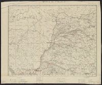
- Beinecke Rare Book and Manuscript Library > Belgian Congo : the Itimbiri River and country between the Welle and Aruwimi Rivers / from prismatic compass traverses and astonomical observations by Messrs C.A., A.E.H. and R.L. Reid.
- Creator:
- Royal Geographical Society (Great Britain)
- Published / Created:
- 1911
- Call Number:
- 652 Ar86 1911A
- Container / Volume:
- BRBL_00343
- Image Count:
- 1
- Resource Type:
- Maps, Atlases & Globes
- Alternative Title:
- Chart of the River Aruwimi and The River Aruwimi [cartographic material]
- Description:
- "The Geographical Journal, 1911".
- Publisher:
- The Society,
- Subject (Geographic):
- Congo (Democratic Republic)--Maps
- Found in:
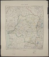
- Beinecke Rare Book and Manuscript Library > Belgian Congo. Chart of the River Aruwimi : from a survey by Robt. L. Reid, 1908-10.
- Published / Created:
- 1918-1919.
- Call Number:
- 65 1918
- Container / Volume:
- BRBL_00341
- Image Count:
- 3
- Resource Type:
- Maps, Atlases & Globes
- Alternative Title:
- Germany. Reichskolonialamt. Mittelafrika in Karten 1:2 000 000.
- Description:
- Blatt I -- Blatt II -- Blatt III -- Blatt IV.
- Publisher:
- Dietrich Reimer (Ernst Vohsen),
- Subject (Geographic):
- Angola--Maps and Congo (Democratic Republic)--Maps
- Subject (Name):
- Dietrich Reimer Verlag (Berlin, Germany)
- Found in:
- Beinecke Rare Book and Manuscript Library > Belgisch-Kongo und Angola [cartographic material] : in 4 Blatt.
- Creator:
- Belgium. Ministère des colonies. Service cartographique
- Published / Created:
- [1928-1932?]
- Call Number:
- 652 1932
- Container / Volume:
- BRBL_00342
- Image Count:
- 3
- Resource Type:
- Maps, Atlases & Globes
- Description:
- Feuille I. Province d'Equateur -- Feuille II. Province Orientale et Territoires du Ruanda et d l'Urundi -- Feuille IV. Province du
- Publisher:
- The Service,
- Subject (Geographic):
- Congo (Democratic Republic)--Maps
- Found in:
- Beinecke Rare Book and Manuscript Library > Congo Belge en 4 feuilles [cartographic material].
- Creator:
- Great Britain. War Office. General Staff. Geographical Section
- Published / Created:
- 1921
- Call Number:
- 652 1921
- Container / Volume:
- BRBL_00342
- Image Count:
- 1
- Resource Type:
- Maps, Atlases & Globes
- Description:
- Information on map as of 1918.
- Publisher:
- Geographical Section, General Staff,
- Subject (Geographic):
- Congo (Democratic Republic)--Maps
- Found in:
- Beinecke Rare Book and Manuscript Library > Congo Belge.
- Published / Created:
- 1908
- Call Number:
- 652gme 1908
- Container / Volume:
- BRBL_00343
- Image Count:
- 1
- Resource Type:
- Maps, Atlases & Globes
- Alternative Title:
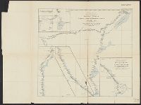
- Levels along lines of projected railways from the Upper Congo to Albert Nyanza and Tanganyika and Projected railways, Congo State
- Description:
- "The Geographical Journal, 1908."
- Publisher:
- Royal Geographical Society,
- Subject (Geographic):
- Congo (Democratic Republic)--Maps
- Subject (Name):
- Royal Geographical Society (Great Britain)
- Subject (Topic):
- Railroads--Congo (Democratic Republic)--Maps, Railroads--Sudan--Maps, and Railroads--Uganda--Maps
- Found in:
- Beinecke Rare Book and Manuscript Library > Congo State. Levels along lines of projected railways from the Upper Congo to Albert Nyanza and Tanganyika [cartographic material] / from Belgian official surveys.
- Creator:
- Conrad, Joseph, 1857-1924
- Published / Created:
- [1910?]
- Call Number:
- 652 1910
- Container / Volume:
- BRBL_00342
- Image Count:
- 1
- Resource Type:
- Maps, Atlases & Globes
- Description:
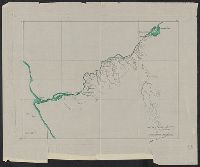
- Manuscript map showing locations along Congo River. River noted in green.
- Subject (Geographic):
- Congo (Democratic Republic)--Maps
- Subject (Name):
- Conrad, Joseph,--1857-1924.--Heart of darkness and Conrad, Joseph,--1857-1924--Travel--Congo (Democratic Republic)
- Found in:
- Beinecke Rare Book and Manuscript Library > Map of Congo Basin : showing path traveled by Joseph Conrad Korzeniowski.
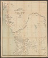
- Published / Created:
- [between 1878 and 1897?]
- Call Number:
- 65 1877
- Container / Volume:
- BRBL_00341
- Image Count:
- 1
- Resource Type:
- Maps, Atlases & Globes
- Description:
- Mounted on linen.
- Publisher:
- Sampson, Low, Marston, Searle & Rivington,
- Subject (Geographic):
- Africa, Central--Maps, Congo (Democratic Republic)--Maps, and Congo River--Maps
- Subject (Name):
- Sampson Low, Marston, Searle & Rivington and Stanley, Henry M. (Henry Morton), 1841-1904
- Found in:
- Beinecke Rare Book and Manuscript Library > Map showing the western half of Equatorial Africa and the explorations by land and water of Henry M. Stanley in the years 1874-77.
- Creator:
- Langhans, Paul, 1867-1952
- Published / Created:
- 1902
- Call Number:
- 652 M36 1902
- Container / Volume:
- BRBL_00343
- Image Count:
- 1
- Resource Type:
- Maps, Atlases & Globes
- Alternative Title:
- Marungu und Utembue
- Publisher:
- Justus Perthes,
- Subject (Geographic):
- Congo (Democratic Republic)--Maps
- Found in:
- Beinecke Rare Book and Manuscript Library > Spezialkarte von Marungu und Utembue ... / entworfen von Paul Langhans ; aut. v. C. Sch.