Sanborn fire insurance maps are a rich source of historic data on the urban built environment of North America during the 19th and early 20th centuries. The atlases were created for the purpose of underwriting fire insurance policies, which depended u...
Alternative Title:
Mar. 1891, Westport Conn. Westport, Fairfield Co., Conn.
Description:
"4350 2 sheets."
Subject (Geographic):
Saugatuck (Conn.)--Maps and Westport (Conn.)--Maps
Subject (Name):
Library of Congress Stamp
Subject (Topic):
Fire risk assessment--Connecticut--Saugatuck--Maps, Fire risk assessment--Connecticut--Westport--Maps, Real property--Connecticut--Saugatuck--Maps, and Real property--Connecticut--Westport--Maps
Sanborn fire insurance maps are a rich source of historic data on the urban built environment of North America during the 19th and early 20th centuries. The atlases were created for the purpose of underwriting fire insurance policies, which depended u...
Description:
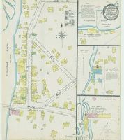
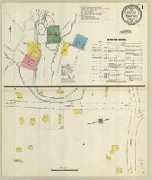
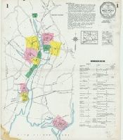
Contains information on population, prevailing winds, water facilities and fire department.
Subject (Geographic):
Westport (Conn.)--Maps
Subject (Name):
Library of Congress Stamp
Subject (Topic):
Fire risk assessment--Connecticut--Westport--Maps and Real property--Connecticut--Westport--Maps
Sanborn fire insurance maps are a rich source of historic data on the urban built environment of North America during the 19th and early 20th centuries. The atlases were created for the purpose of underwriting fire insurance policies, which depended u...
Alternative Title:
Aug. 1896, Westport Conn.
Description:
"3 sheets. 670."
Subject (Geographic):
Westport (Conn.)--Maps
Subject (Name):
Library of Congress Stamp
Subject (Topic):
Fire risk assessment--Connecticut--Westport--Maps and Real property--Connecticut--Westport--Maps
Sanborn fire insurance maps are a rich source of historic data on the urban built environment of North America during the 19th and early 20th centuries. The atlases were created for the purpose of underwriting fire insurance policies, which depended u...
Alternative Title:
March 1910, Westport Conn. Westport, including Saugatuck, Fairfield County, Connecticut
Description:
"2514 (7 sheets)"
Subject (Geographic):
Saugatuck (Conn.)--Maps and Westport (Conn.)--Maps
Subject (Name):
Library of Congress Stamp
Subject (Topic):
Fire risk assessment--Connecticut--Saugatuck--Maps, Fire risk assessment--Connecticut--Westport--Maps, Real property--Connecticut--Saugatuck--Maps, and Real property--Connecticut--Westport--Maps
Sanborn fire insurance maps are a rich source of historic data on the urban built environment of North America during the 19th and early 20th centuries. The atlases were created for the purpose of underwriting fire insurance policies, which depended u...
Alternative Title:
Sept. 1923, Westport Conn. Westport, including Saugatuck, Fairfield County, Connecticut
Description:
"(1238) 12 sheets."
Subject (Geographic):
Saugatuck (Conn.)--Maps and Westport (Conn.)--Maps
Subject (Name):
Library of Congress Stamp
Subject (Topic):
Fire risk assessment--Connecticut--Saugatuck--Maps, Fire risk assessment--Connecticut--Westport--Maps, Real property--Connecticut--Saugatuck--Maps, and Real property--Connecticut--Westport--Maps
Sanborn fire insurance maps are a rich source of historic data on the urban built environment of North America during the 19th and early 20th centuries. The atlases were created for the purpose of underwriting fire insurance policies, which depended u...
Alternative Title:
Mar. 1931, Westport Conn. Westport, including Saugatuck, Fairfield County, Connecticut
Description:
"(1225) 15 sheets."
Subject (Geographic):
Saugatuck (Conn.)--Maps and Westport (Conn.)--Maps
Subject (Name):
Library of Congress Stamp
Subject (Topic):
Fire risk assessment--Connecticut--Saugatuck--Maps, Fire risk assessment--Connecticut--Westport--Maps, Real property--Connecticut--Saugatuck--Maps, and Real property--Connecticut--Westport--Maps
"A companion print to BMSat 7797. Three stout and elderly men sit at a small round table in a small enclosure immediately outside a house (right), and bounded by a high wall with a spiked gate. One (left) sleeps, his hat and wig on the ground beside h...
Description:
Title from caption etched below image.
Publisher:
Pub. Dec. 20, 1790, by S.W. Fores, N. 3 Piccadilly