1.

- Creator:
- Keulen, Johannes van, fl. 1726-1753.
- Published / Created:
- [ca. 1734]
- Call Number:
- 1973 Folio 18
- Image Count:
- 1
- Resource Type:
- Maps, Atlases & Globes
- Description:
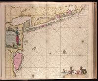
- "Met prevelegie voor 15 Jaer"., Appeared in Gerard van Keulen's Nieuwe groote ligtende Zee-Fakkel ... 1734; cf. Koeman, C. Atlantes Neerlandici, IV, Keu 45, map 9., Backed with paper. Ms. no. "43" in upper right-hand corner. Sheet measures 53.7 x 62.9 cm. No. 41 of 87 maps bound together., Bar scales given in "Duytsche Mylen," "Spaensche Mylen," and "Eng. Fratn. Mylen"., Depths shown by soundings., and With north oriented towards the bottom.
- Publisher:
- By Ioannes van Keulen ...,
- Subject (Geographic):
- West Frisian Islands (Netherlands)--Maps--Early works to 1800.
- Subject (Name):
- Keulen, Gerard van. Nieuwe groote lichtende zee-fakkel.
- Subject (Topic):
- Nautical charts--Netherlands--West Frisian Islands--Early works to 1800.
- Found in:
- Beinecke Rare Book and Manuscript Library > Nieuwe pascaert waar in te sien is de gaten van Texel en 't Vlie [cartographic material] : met alle syn mercken, diepte en droogte / alles op 't nieuws oversien en van veel fouten verbetert ...