Search
You Searched For
Search Results
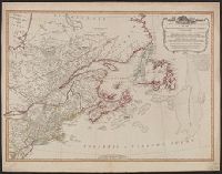
- Published / Created:
- 12th May, 1794.
- Call Number:
- 71 1794L
- Container / Volume:
- BRBL_00726
- Image Count:
- 1
- Resource Type:
- Maps, Atlases & Globes
- Description:
- Appears in Laurie & Whittle's New and elegant imperial sheet atlas.
- Publisher:
- Publish'd by Laurie & Whittle, 53 Fleet Street,
- Subject (Geographic):
- Canada--Maps--Early works to 1800, Great Britain--Colonies--America--Maps--Early works to 1800, and Northeastern States--Maps--Early works to 1800
- Subject (Name):
- Robert Laurie and James Whittle and Robert Laurie and James Whittle. New and elegant imperial sheet atlas
- Found in:
- Beinecke Rare Book and Manuscript Library > A new and correct map of the British colonies in North America comprehending eastern Canada with the province of Quebec, New Brunswick, Nova Scotia, and the Government of Newfoundland [cartographic material] : with the adjacent states of New England, Verm
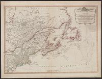