Search
You Searched For
Search Results
- Published / Created:
- March 15, 1832
- Call Number:
- 75 1850
- Container / Volume:
- BRBL_00689
- Image Count:
- 2
- Resource Type:
- Maps, Atlases & Globes
- Alternative Title:
- Atlas of the United States of North America.
- Description:
- From An atlas of the United States of North America ... London : Published by Simpkin & Marshall and Thomas Wardle, Philadelphia, 1832.
- Publisher:
- I.T. Hinton & Simpkin & Marshall,
- Subject (Geographic):
- United States--Maps
- Subject (Name):
- Fenner, Sears & Co, Hinton, Isaac Taylor, 1799-1847, and Simpkin and Marshall
- Subject (Topic):
- Geology--United States--Maps
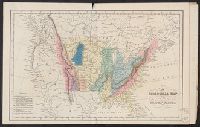
- Found in:
- Beinecke Rare Book and Manuscript Library > A geological map of the United States [cartographic material].
- Creator:
- Burr, Henry A
- Published / Created:
- 1850
- Call Number:
- 75 1850
- Container / Volume:
- BRBL_00400
- Image Count:
- 2
- Resource Type:
- Maps, Atlases & Globes
- Alternative Title:
- Carl I. Wheat map collection. CU-BANC and New map of the United States and Canada
- Description:
- Covers southern Canada, including New Brunswick, Prince Edward Island, and Nova Scotia.
- Publisher:
- Published by J. Disturnell,
- Subject (Geographic):
- Canada--Maps and United States--Maps
- Subject (Name):
- Atwood, John M., b. ca. 1818 and Disturnell, John, 1801-1877
- Subject (Topic):
- Railroads--United States--Maps
- Found in:
- Beinecke Rare Book and Manuscript Library > Disturnell's new map of the United States and Canada : showing all the canals, rail roads, telegraph lines and principal stage routes / drawn by Henry A. Burr, topographer to the Post Office Dep't., Washington, D.C. ; engraved by J.M. Atwood, N.Y.