Cvliacanae, Americae regionis, descriptio, Hispaniolae, Cubae, aliarumque Insularum circumiacientium, delineatio, and Hispaniolae, Cvbae, aliarvmqve Insvlarvm circvmiacientivm, delineatio
Description:
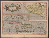
Date based on Koeman; however, this state of the map, on which the Tropic of Capricorn appears, is also cited in Koeman as a correction dated 1592/95. and Top map shows modern province of Culiacan in Mexico. Lower map shows the West Indies, Bahamas, southern Florida and eastern Yucatan.
Publisher:
Christophe Plantin,
Subject (Geographic):
Cuba--Maps--Early works to 1800, Culiacán (Sinaloa, Mexico)--Maps--Early works to 1800, and West Indies--Maps--Early works to 1800
Subject (Name):
Ortelius, Abraham, 1527-1598. Theatrum orbis terrarum and Plantin, Christophe, approximately 1520-1589