Search
You Searched For
Search Results
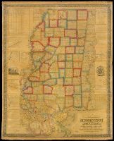
- Creator:
- La Tourrette, John, compiler, publisher
- Published / Created:
- 1845.
- Call Number:
- Roll Map 420
- Image Count:
- 10
- Resource Type:
- cartographic image
- Alternative Title:
- State of Mississippi, with a large portion of Louisiana and Alabama
- Description:
- BEIN Roll Map 420: Mounted on linen. Printed label on verso: Rhode Island Historical Society.
- Publisher:
- Compiled & published by John La Tourrette and Engraved by S. Stiles, Sherman & Smith
- Subject (Geographic):
- Mississippi, Alabama, Louisiana, Alabama., Louisiana., and Mississippi.
- Subject (Topic):
- Administrative and political divisions
- Found in:
- Beinecke Rare Book and Manuscript Library > An accurate map or delineation of the state of Mississippi, with a large portion of Louisiana & Alabama : showing the communication of land and water between the cities of New Orleans and Mobile : carefully reduced from the original surveys of the United States : being laid off into congressional townships, and divided into mile squares or sections, on the plan adopted by the General Government for surveying Public Lands, so that persons may point to the tract on which they live
