
You Searched For
1 - 8 of 8
Search Results
2.

- Creator:
- Moll, Herman, -1732
- Published / Created:
- [1729?]
- Call Number:
- 11 1724
- Container / Volume:
- BRBL_00680
- Image Count:
- 1
- Resource Type:
- Maps, Atlases & Globes
- Description:
- Imperfect: mutilated and torn along folds, with some loss of text. Cross collection no. 33.
- Publisher:
- Printed for and sold by I. Bowles, map and printseller at the Black Horse in Cornhill & by T. Bowles map & print seller next to ye Chapter house in St. Paul's Church yard, and by P. Overton map & print seller near St. Dunstan's Church Fleet Street and by
- Subject (Name):
- Bowles, John, 1701-1779, bookseller, Bowles, Thomas, -1767, bookseller, and Overton, Philip, -1751, bookseller
- Subject (Topic):
- World maps--Early works to 1800
- Found in:
- Beinecke Rare Book and Manuscript Library > A new and correct map of the world laid down according to the newest discoveries, and from the most exact observations / [cartographic material] / by Herman Moll, geographer.
3.
- Creator:
- Moll, Herman, -1732
- Published / Created:
- 1714
- Call Number:
- 40 1714
- Container / Volume:
- BRBL_00196
- Image Count:
- 1
- Resource Type:
- Maps, Atlases & Globes
- Description:
- "Note: the post roads in this map are taken from Iacobo Cantelli da Vignola the Duke of Modena's geographer."
- Publisher:
- printed for H. Moll...Ino. Bowles...T. Bowles...Philip Overton,
- Subject (Geographic):
- Italy--Maps--Early works to 1800 and Mediterranean Region--Maps--Early works to 1800
- Subject (Name):
- Bowles, John, 1701-1779, Bowles, Thomas, -1767, Cantelli da Vignola, Giacomo, 1643-1719, and Overton, Philip, -1751
- Found in:
- Beinecke Rare Book and Manuscript Library > A new map of Italy : distinguishing all the sovereignties in it, whether states, kingdoms, dutchies, principalities, republicks &c. With the post roads, and many remarks not extant in any map. According to ye newest and most exact observations / by H. Mol
4.

- Creator:
- Moll, Herman, -1732
- Published / Created:
- 1720
- Call Number:
- 71 1720C
- Container / Volume:
- BRBL_00687
- Image Count:
- 1
- Resource Type:
- Maps, Atlases & Globes
- Alternative Title:
- Harbour of Annapolis Royal, Indian fort Sasquesahanok, and Map of ye mouth of Mississipi and Mobile rivers &c
- Description:
- Appears in Moll's The world described.
- Publisher:
- Sold by H. Moll over against Devereus Court between Temple Bar and St. Clements Church in the Strand ... [and] sold by Tho: Bowles ... Iohn King ... Iohn Bowles,
- Subject (Geographic):
- North America--Maps--Early works to 1800
- Subject (Name):
- Bowles, John, 1701-1779, bookseller, Bowles, Thomas, -1767, bookseller, and Moll, Herman, -1732. World described
- Found in:
- Beinecke Rare Book and Manuscript Library > A new map of the north parts of America claimed by France under ye names of Louisiana, Mississipi, Canada and New France with ye adjoyning territories of England and Spain ... : the projection of this map is call'd Mercator's, and it is laid down accordin
5.

- Creator:
- Moll, Herman, -1732
- Published / Created:
- 1720
- Call Number:
- 71 1720C
- Container / Volume:
- BRBL_00361
- Image Count:
- 1
- Resource Type:
- Maps, Atlases & Globes
- Alternative Title:
- Harbour of Annapolis Royal, Indian fort Sasquesahanok, and Map of ye mouth of Mississipi and Mobile rivers &c
- Description:
- Appears in Moll's The world described.
- Publisher:
- Sold by H. Moll over against Devereus Court between Temple Bar and St. Clements Church in the Strand ... [and] sold by Tho: Bowles ... Iohn King ... Iohn Bowles,
- Subject (Geographic):
- North America--Maps--Early works to 1800
- Subject (Name):
- Bowles, John, 1701-1779, bookseller, Bowles, Thomas, -1767, bookseller, and Moll, Herman, -1732. World described
- Found in:
- Beinecke Rare Book and Manuscript Library > A new map of the north parts of America claimed by France under ye names of Louisiana, Mississipi, Canada and New France with ye adjoyning territories of England and Spain ... : the projection of this map is call'd Mercator's, and it is laid down accordin
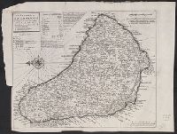
6.
- Creator:
- Moll, Herman, -1732
- Published / Created:
- [1736]
- Call Number:
- 867 1729
- Container / Volume:
- BRBL_00696
- Image Count:
- 1
- Resource Type:
- Maps, Atlases & Globes
- Description:
- Cross Collection no. 307.
- Publisher:
- Printed and sold by Tho. Bowles, next ye Chapter House in St. Pauls Church yard & I. Bowles at the Black Horse in Cornhill,
- Subject (Geographic):
- Barbados--Maps--Early works to 1800
- Subject (Name):
- Bowles, John, 1701-1779, printer, Bowles, Thomas, -1767, printer, and Moll, Herman, -1732. Atlas minor
- Found in:
- Beinecke Rare Book and Manuscript Library > The island of Barbadoes [cartographic material] : divided into its parishes, with the roads, paths, &c. according to an actual and accurate survey / by H. Moll, geographer.
7.
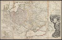
- Creator:
- Bowles, Thomas, -1767
Midwinter, Daniel, active 1698-1725
Moll, Herman, -1732
Overton, Philip, -1751 - Published / Created:
- [1708?]
- Call Number:
- 352 1708
- Container / Volume:
- BRBL_00104
- Image Count:
- 1
- Resource Type:
- Maps, Atlases & Globes
- Description:
- Includes text, decorative cartouche with port. of Peter the Great, and insets of northern Russia, the Don River Delta, and the Volga River.
- Publisher:
- Printed for H. Moll between Temple Bar & St. Clem. Church in ye Strand, D. Midwinter at ye 3 Crowns in St. Pauls Church yard, P. Overton over against S. Dunstans Church in Fleetstreet & T. Bowles next to the chapter house in St. Pauls Church yard,
- Subject (Geographic):
- Europe, Eastern--Maps--Early works to 1800 and Russia--Maps--Early works to 1800
- Found in:
- Beinecke Rare Book and Manuscript Library > To his most serene and august majesty, Peter Alexovitz, absolute lord of Russia &c., this map of Moscovy, Poland, Little Tartary, and ye Black Sea &c. is most humbly dedicated by H. Moll, geographer.
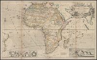
8.
- Creator:
- Moll, Herman, -1732
- Published / Created:
- [1710]
- Call Number:
- 60 1708
- Container / Volume:
- BRBL_00322
- Image Count:
- 1
- Resource Type:
- Maps, Atlases & Globes
- Alternative Title:
- This map of Africa
- Description:
- "According to the newest and most exact observations."
- Publisher:
- Printed for H. Moll over against Devereux Court without Temple Bar, D. Midwinter at the 3 Crowns in St. Pauls church yard and Tho. Bowles print and mapseller next to the chapter house in St. Pauls church yard by Philip Overton, map and printseller near St
- Subject (Geographic):
- Africa--Maps--Early works to 1800
- Subject (Name):
- Bowles, Thomas, -1767, Midwinter, Daniel, active 1698-1725, and Overton, Philip, -1751
- Found in:
- Beinecke Rare Book and Manuscript Library > To the right honourable Charles, Earl of Peterborow and Monmouth, &c this map of Africa ... is most humbly dedicated / by your Lordship's humble servant H: Moll geographer.