1.

- Creator:
- Royal Geographical Society (Great Britain)
- Published / Created:
- 1909
- Call Number:
- 19 1909A
- Container / Volume:
- BRBL_00013
- Image Count:
- 1
- Resource Type:
- Maps, Atlases & Globes
- Alternative Title:
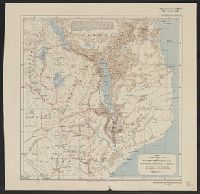
- General map showing the explorations and surveys of the Expedition, 1907-1909 and The Geographical journal.
- Description:
- Map showing the area explored by Ernest Shackleton's British Antarctic Expedition, 1907-1909. The routes shown cover the areas explored or surveyed along the eastern coast of South Victoria Land, including the route of the South Magnetic Pole Party, a...
- Publisher:
- Royal Geographical Society,
- Subject (Geographic):
- Antarctica--Discovery and exploration--Maps, South Magnetic Pole (Antarctica)--Discovery and exploration--Maps, South Pole--Discovery and exploration--Maps, and South Victoria Land (Antarctica)--Discovery and exploration--Maps
- Subject (Name):
- British Antarctic Expedition (1907-1909)--Maps, Royal Geographical Society (Great Britain). Australian Antarctic Division, and Shackleton, Ernest Henry Sir, 1874-1922
- Subject (Topic):
- Scientific expeditions--Antartica--South Victoria Land--Maps and Scientific expeditions--South Pole--Maps
- Found in:
- Beinecke Rare Book and Manuscript Library > British Antarctic Expedition, 1907 [cartographic material] : general map showing the explorations and surveys of the Expedition, 1907-09.