1.

- Creator:
- Blodget, Samuel, 1724-1807
- Published / Created:
- February the 2d, 1756.
- Call Number:
- 771hc H864 1756
- Container / Volume:
- BRBL_00495
- Image Count:
- 1
- Resource Type:
- Maps, Atlases & Globes
- Abstract:
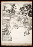
- Subject: Map of Hudson River from New York City to Lake George, with plans of Fort Edward and Fort William Henry. Also includes views of the first and second engagements during the Battle of Lake George. In the "First engagement" soldiers are seen shootin
- Description:
- 771hc H864 1756: Stamp "Yale Horace Brown 1900S." Accompanied by reproduction of map [with stamp "Yale Horace Brown 1900S"]. and Coordinates not present on map of Hudson River and are approximated.
- Publisher:
- Published according to act of Parliament,
- Subject (Geographic):
- Hudson River (N.Y. and N.J.)--Maps, New York (State)--Lake George, United States--History--French and Indian War, 1754-1763--Campaigns--Pictorial works, and United States--Hudson River
- Subject (Name):
- Brown, Horace--Stamp, French and Indian War (United States : 1754-1763), Jefferys, Thomas, -1771, engraver, and Lake George, Battle of (New York : 1755)
- Subject (Topic):
- Lake George, Battle of, N.Y., 1755--Pictorial works
- Found in:
- Beinecke Rare Book and Manuscript Library > A Prospective view of the battle fought near Lake George, on the 8th of Sepr. 1755 : between 2000 English, with 250 Mohawks, under the command of Gen. Johnson: & 2500 French & indians under the command of Genl. Dieskau in which the English were victorious