Skip to search
Skip to main content
Skip to first result
Search
You Searched For
Language
English
Publication Place
[Washington, D.C. :
Search Results
Creator:
Published / Created:
1943?]
Call Number:
381hc 1943
Container / Volume:
BRBL_00174
Image Count:
1
Resource Type:
Maps, Atlases & Globes
Description:
"January 18, 1943."
Publisher:
OSS Repro. Section,
Subject (Geographic):
Brittany (France)--Maps
Subject (Topic):
Coast defenses--France--Brittany--Maps and Military geography--France--Brittany--Maps
Found in:
Beinecke Rare Book and Manuscript Library > Brittany, south coast [cartographic material] : beaches and objectives / compiled and drawn in the Branch of Research and Analysis, OSS.
Published / Created:
1851].
Call Number:
11cfk 1850B-3
Container / Volume:
BRBL_00770
Image Count:
1
Resource Type:
Maps, Atlases & Globes
Alternative Title:
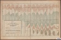
Maury's Wind And Current Charts North Atlantic Ocean, Maury's Wind And Current Charts North Atlantic Ocean ; Series B., and Series B
Description:
"The figures show the number of vessels that have lost or found, and the latitude in which they have lost or found, the winds and calms designated."
Publisher:
National Observatory,
Subject (Geographic):
Atlantic Ocean--Maps
Subject (Name):
Maury, Matthew Fontaine, 1806-1873
Subject (Topic):
Trade winds--Maps
Found in:
Beinecke Rare Book and Manuscript Library > Chart Of The North East Trade Winds [cartographic material] / National Observatory.
Creator:
Published / Created:
1855]
Call Number:
74 1855
Container / Volume:
BRBL_00394
Image Count:
1
Resource Type:
Maps, Atlases & Globes
Abstract:
Chart including Smith Strait, Peabody Bay, and Kennedy Channel along Grinnellland [i.e. Grinnell Peninsula], Arctic Canada.
Description:
"Ackerman Lith."
Publisher:
G.P.O.,
Subject (Geographic):
Arctic regions--Discovery and exploration--Maps
Subject (Topic):
Discoveries in geography--Maps
Found in:
Beinecke Rare Book and Manuscript Library > Chart exhibiting the discoveries of the Second-American-Grinnell-Expedition in search of Sir John Franklin : unrevised from the original material and projected on the spot / E. K. Kent.
Creator:
Published / Created:
1900?]
Call Number:
23gmf 1900
Container / Volume:
BRBL_00021
Image Count:
1
Resource Type:
Maps, Atlases & Globes
Publisher:
U.S. Treasury Department, Bureau of Statistics,
Subject (Geographic):
Pacific Area--Maps
Found in:
Beinecke Rare Book and Manuscript Library > Commercial highways between United States and Asia and the islands of the Pacific / U.S. Treasury Department, Bureau of Statistics.
Creator:
Published / Created:
1965
Call Number:
844gmb R524 1965
Container / Volume:
BRBL_00617
Image Count:
1
Resource Type:
Maps, Atlases & Globes
Description:
Below scale: U.S. Geological Survey.
Publisher:
U.S. Geological Survey?],
Subject (Geographic):
Riverside County (Calif.)--Maps
Subject (Name):
Blanchard, N. K
Subject (Topic):
Trails--California--Riverside County--Maps
Found in:
Beinecke Rare Book and Manuscript Library > Desert Riders trail map / by D.V. Garstin & N.K. Blanchard.
Creator:
Published / Created:
[1879]
Call Number:
833g 1879
Container / Volume:
BRBL_00586
Image Count:
1
Resource Type:
Maps, Atlases & Globes
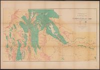
Description:
"April 1879."
Publisher:
Julius Bien, Lith., and The Survey ;
Subject (Name):
Hayden, F. V. (Ferdinand Vandeveer), 1829-1887
Subject (Topic):
Land capability for agriculture--Idaho--Maps, Land capability for agriculture--Utah--Maps, Land capability for agriculture--Wyoming--Maps, Natural resources--Idaho--Maps, and Natural resources--Utah--Maps
Found in:
Beinecke Rare Book and Manuscript Library > Economic map of portions of Wyoming, Idaho and Utah / Department of the Interior, U.S. Geological and Geographical Survey of the Territories ; F.V. Hayden, U.S. geologist in charge.
Creator:
Published / Created:
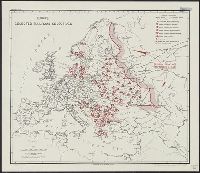
1943?]
Call Number:
30gme 1943
Container / Volume:
BRBL_00038
Image Count:
1
Resource Type:
Maps, Atlases & Globes
Description:
"Map no. 1951 January 9, 1943."
Publisher:
OSS Reproduction Section,
Subject (Geographic):
Europe--Maps
Subject (Topic):
Railroads--Europe--Maps
Found in:
Beinecke Rare Book and Manuscript Library > Europe : selected railroad objectives / compiled and drawn in the Branch of Research and Analysis, OSS.
Creator:
Published / Created:
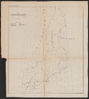
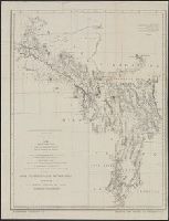
1872?]
Call Number:
7821 1872
Container / Volume:
BRBL_00506
Image Count:
1
Resource Type:
Maps, Atlases & Globes
Alternative Title:
Explorations in Nevada and Arizona. and Preliminary topographical map embracing in skeleton a portion only of the notes from surveys made in accordance with Par.II Special Orders No. 109 War Dept., March 18th, 1871 and letter of instructions of Brig. General
Description:
"Note: This map is a hasty and partial compilation from the topographical data already received, many still remaining en route."
Publisher:
G.P.O.?,
Subject (Geographic):
Southwest, New--Discovery and exploration--Maps and Southwest, New--Maps
Subject (Name):
Lockwood, Daniel W, Lyle, D. A, Nell, Louis, United States. Army. Corps of Engineers. Preliminary report of explorations in Nevada and Arizona, and Wheeler, George M. (George Montague), 1842-1905
Found in:
Beinecke Rare Book and Manuscript Library > Explorations and surveys south of Central Pacific R.R., War Department : preliminary topographical map embracing in skeleton a portion only of the notes from surveys made in accordance with Par.II Special Orders No. 109 War Dept., March 18th, 1871 and let
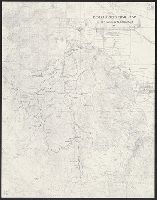
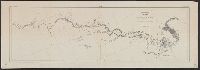
Published / Created:
1898
Call Number:
848 T15 1898
Container / Volume:
BRBL_00634
Image Count:
1
Resource Type:
Maps, Atlases & Globes
Description:
"W.J. Peters, Topographer in Charge. Topography by W.J. Peters and Alfred H. Brooks, Assistant Geologist."
Publisher:
U.S. Congress],
Subject (Geographic):
Tanana River (Alaska)--Maps and White River (Alaska)--Maps
Subject (Name):
Brooks, Alfred H, Geological Survey (U.S.), Peters, W. J, and United States. Congress. (55th, 3rd : 1898)
Found in:
Beinecke Rare Book and Manuscript Library > Explorations in Alaska 1898 portions of Tanana and White Rivers.
Creator:
Published / Created:
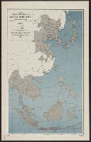
1943
Call Number:
556gme 1943
Container / Volume:
BRBL_00294
Image Count:
1
Resource Type:
Maps, Atlases & Globes
Description:
"12 March 1943."
Publisher:
Office of Strategic Services],
Subject (Geographic):
East Asia--Maps
Subject (Name):
United States. Office of Strategic Services. Research and Analysis Branch
Subject (Topic):
Railroads--East Asia--Maps, Railroads--Southeast Asia--Maps, and World War, 1939-1945--Japan--Territorial expansion--Maps
Found in:
Beinecke Rare Book and Manuscript Library > Far East, Japanese occupied area, major railroads [cartographic material] / Board of Economic Warfare, Enemy Branch ; drawn in R. and A., OSS.