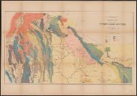
Geological and Geographical Survey of the Territories (U.S.)
Published / Created:
[1878?]
Call Number:
833ca 1878C
Container / Volume:
BRBL_00585
Image Count:
1
Resource Type:
Maps, Atlases & Globes
Description:
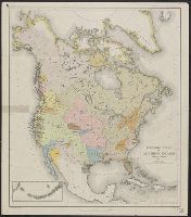
Relief shown by spot heights.
Publisher:
Julius Bien, Lith., and The Survey] ;
Subject (Name):
Endlich, F. M. (Frederick Miller), 1851-1899, Hayden, F. V. (Ferdinand Vandeveer), 1829-1887, Peale, A. C. (Albert Charles), 1849-1914, and St. John, O. H. (Orestes Henry)
Subject (Topic):
Geology--Idaho--Maps, Geology--Utah--Maps, and Geology--Wyoming--Maps
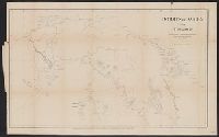
"To accompany the Commissioner's joint report dated November 26, 1951. Upon the establishment of the boundary from Tongass Passage to Mount St. Elias in accordance with the convention of January 24, 1903, the award of the tribunal, appointed under the...
Publisher:
U.S. G.P.O.,
Subject (Geographic):
Alaska--Boundaries--Canada--Maps, Canada--Boundaries--United States--Maps, and United States--Boundaries--Canada--Maps