Skip to search
Skip to main content
Skip to first result
Search
You Searched For
Genre
Maps
Publication Place
[Washington :
Search Results
Creator:
Published / Created:
1945
Call Number:
556 1945A
Container / Volume:
BRBL_00293
Image Count:
1
Resource Type:
Maps, Atlases & Globes
Description:
"No. 5581--R & A, OSS.", "Provisional edition.", and Also covers adjoining portions of the U.S.S.R., China and the Philippines.
Publisher:
Reproduction Branch, Office of Strategic Services],
Subject (Geographic):
East Asia--Maps and Japan--Maps
Subject (Name):
United States. Office of Strategic Services. Reproduction Branch
Found in:
Beinecke Rare Book and Manuscript Library > Approaches to Japan.
Creator:
Published / Created:
1944
Call Number:
57gm 1944
Container / Volume:
BRBL_00306
Image Count:
1
Resource Type:
Maps, Atlases & Globes
Alternative Title:
Central Japan :
Description:
"30 September 1944"., "No. 5390--R & A, OSS.", "Provisional edition.", Includes glossary and reliability diagram., and Relief shown by shading.
Publisher:
Office of Strategic Services],
Subject (Topic):
Harbors--Japan--Maps and Roads--Japan--Maps
Found in:
Beinecke Rare Book and Manuscript Library > Central Japan (central and northern Honshu) : roads and water routes.
Creator:
Published / Created:
1915]
Call Number:
97 1915
Container / Volume:
BRBL_00678
Image Count:
1
Resource Type:
Maps, Atlases & Globes
Description:
Blue line print. and Relief shown by form lines and spot heights.
Publisher:
National Geographic Society,
Subject (Geographic):
Machu Picchu Site (Peru)--Maps and Peru--Maps
Subject (Name):
Peruvian Expeditions (1912-1915)
Found in:
Beinecke Rare Book and Manuscript Library > Field map of the Peruvian expeditions of Yale University and the National Geographic Society [cartographic material] / Hiram Bingham, Director.
Creator:
Published / Created:
1945
Call Number:
57gf 1945
Container / Volume:
BRBL_00305
Image Count:
1
Resource Type:
Maps, Atlases & Globes
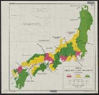
Description:
"Degree of industrial concentration ... in 1943.", "No. 8120--R & A, OSS.", "Provisional edition.", and Includes inset of Hokkaido.
Publisher:
Reproduction Branch, Office of Strategic Services],
Subject (Geographic):
Japan--Maps
Subject (Name):
United States. Office of Strategic Services. Reproduction Branch
Subject (Topic):
Industrial concentration--Japan--Maps and Industries--Japan--Maps
Found in:
Beinecke Rare Book and Manuscript Library > Japan : industrial concentration by prefectures.
Creator:
Published / Created:
1944
Call Number:
57gm 1941
Container / Volume:
BRBL_00306
Image Count:
1
Resource Type:
Maps, Atlases & Globes
Description:
"No. 5503--R & A, OSS.", "Provisional edition.", and Includes inset of Hokkaido.
Publisher:
Office of Strategic Services],
Subject (Topic):
Radio stations--Japan--Maps, Telegraph--Japan--Maps, and Telephone--Japan--Maps
Found in:
Beinecke Rare Book and Manuscript Library > Japan, radiotelephone and radiotelegraph stations : 1941.
Creator:
Published / Created:
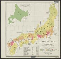
1945
Call Number:
57eb 1940
Container / Volume:
BRBL_00305
Image Count:
1
Resource Type:
Maps, Atlases & Globes
Description:
"22 Aug. 1945.", "No. 8118--R & A, OSS.", and Includes inset and statistical chart.
Publisher:
Office of Strategic Services],
Subject (Geographic):
Japan--Administrative and political divisions--Maps
Subject (Name):
United States. Office of Strategic Services. Reproduction Branch
Subject (Topic):
Population density--Japan--Maps
Found in:
Beinecke Rare Book and Manuscript Library > Japan: population densities by prefectures and province.
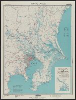
Creator:
Published / Created:
1944
Call Number:
57gm T578 1944
Container / Volume:
BRBL_00307
Image Count:
1
Resource Type:
Maps, Atlases & Globes
Description:
"No. 3997--R & A, OSS.", "Provisional edition, first revision.", and Includes reliability table and inset showing "Waterways of the Tōkyō area."
Publisher:
Reproduction Branch, Office of Strategic Services],
Subject (Geographic):
Kantō Region (Japan)--Maps
Subject (Name):
United States. Office of Strategic Services. Reproduction Branch
Subject (Topic):
Canals--Japan--Kantō Region--Maps
Found in:
Beinecke Rare Book and Manuscript Library > Kantō area : highways and waterways.
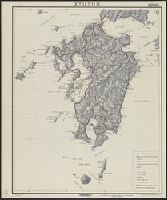
Creator:
Published / Created:
1944
Call Number:
573gm 1944
Container / Volume:
BRBL_00311
Image Count:
1
Resource Type:
Maps, Atlases & Globes
Description:
"No. 3951--R & A, OSS.", "Provisional edition.", and Relief shown by shading.
Publisher:
Office of Strategic Services],
Subject (Geographic):
Kyūshū Region (Japan)--Maps
Found in:
Beinecke Rare Book and Manuscript Library > Kyushu.
Creator:
Published / Created:
1871
Call Number:
833 Y38 1871A
Container / Volume:
BRBL_00584
Image Count:
1
Resource Type:
Maps, Atlases & Globes
Description:
Relief shown by hachures and spot heights.
Publisher:
U.S. G.P.O.],
Subject (Geographic):
Yellowstone National Park--Maps, Topographic
Subject (Name):
Hayden, F. V. (Ferdinand Vandeveer), 1829-1887
Subject (Topic):
Geysers--Wyoming--Maps
Found in:
Beinecke Rare Book and Manuscript Library > Lower Geyser Basin, Fire Hole River, Wyoming Territory : surveyed by the party in charge of F.V. Hayden / compiled and drawn from field notes and sketches of A. Schönborn by E. Hergesheimer.
Creator:
Published / Created:
1891]
Call Number:
787hc At62 1864
Container / Volume:
BRBL_00517A
Image Count:
1
Resource Type:
Maps, Atlases & Globes
Alternative Title:
Operations of the Army under the com'd of Maj. Gen. W.T. Sherman in Georgia. and Siege of Atlanta.
Description:
Also on sheet: Brooks, A.F. Map illustrating the operations of the Army under the com'd of Maj. Gen. W.T. Sherman in Georgia, from May 5th, 1864 to Sep and Plate 88 from: "Atlas to accompany the official records of the Union and Confederate armies 1861-1865."
Publisher:
U.S. War Dept.,
Subject (Geographic):
Atlanta (Georgia)--Maps
Subject (Name):
Brooks, A. F. Map illustrating the operations of the Army under the com'd of Maj. Gen. W. T. Sherman in Georgia, from May 5th, 1864 to Sept. 4th, 1864, Poe, O. M. (Orlando Metcalfe), 1832-1895, and United States. War Dept. Atlas to accom
Subject (Topic):
Atlanta Campaign, 1864--Maps
Found in:
Beinecke Rare Book and Manuscript Library > Map illustrating the siege of Atlanta, Ga. : by the United States forces under command of Maj. Gen. W.T. Sherman from the passage of Peachtree Creek, July 19th 1864 to the commencement of the movement upon the enemy's lines of communication south of Atlan
Branch:v1.68.1 ,Deployed:2025-05-28T09:32:36-04:00