Skip to search
Skip to main content
Skip to first result
Search
You Searched For
Repository
Beinecke Rare Book and Manuscript Library
Creator
Wit, Frederik de
Publication Place
Amstelodami :
Search Results
Creator:
Published / Created:
[170-?]
Call Number:
BrSides Double Folio 2019 113
Image Count:
1
Resource Type:
Maps, Atlases & Globes
Alternative Title:
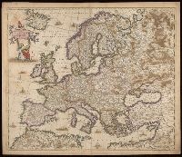
Europae descriptio
Description:
"Amstelodami cum privilegio D.D. ordin. Hollandiae Westfrisiaeq[ue]."
Publisher:
Frederik de Wit,
Subject (Geographic):
Europe--Maps--Early works to 1800.
Found in:
Beinecke Rare Book and Manuscript Library > Nova et accurate divisa in regna et regiones praecipuas Europae descriptio / per F. de Witt ; F. de wit excudit.
Creator:
Published / Created:
[1720?]
Call Number:
11 1720A
Container / Volume:
BRBL_00680
Image Count:
1
Resource Type:
Maps, Atlases & Globes
Alternative Title:
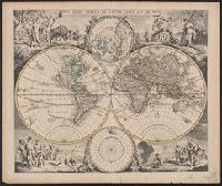
Nova orbis tabvla in lvcem edita
Description:
Allegorical vignettes of the four seasons.
Publisher:
Apud Ioannem Covens et Cornelium Mortier,
Subject (Name):
Cóvens, Jean and Mortier, Corneille
Subject (Topic):
World maps--Early works to 1800
Found in:
Beinecke Rare Book and Manuscript Library > Nova orbis tabula in lucem edita / a. F. de Wit.
Creator:
Published / Created:
1668]
Call Number:
11 1668
Container / Volume:
BRBL_00680
Image Count:
1
Resource Type:
Maps, Atlases & Globes
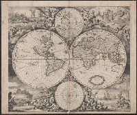
Description:
Imperfect: mutilated along folds, with some loss of text. Cross collection no. 24.
Publisher:
[s.n.,
Subject (Topic):
World maps--Early works to 1800
Found in:
Beinecke Rare Book and Manuscript Library > Nova totius terrarum orbis tabula / [cartographic material] / ex officina F. de Wit.
Creator:
Published / Created:
[1680]
Call Number:
70 1757A
Container / Volume:
BRBL_00686
Image Count:
1
Resource Type:
Maps, Atlases & Globes
Description:
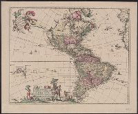
"Cum Privilegio D.D. Ordinum Holl. Westfriliegs."
Publisher:
Ex officina I. Covens et C. Mortier,
Subject (Geographic):
America--Maps--Early works to 1800 and Western Hemisphere--Maps--Early works to 1800
Subject (Name):
Cóvens et Mortier and Wit, Frederik de. Atlas
Found in:
Beinecke Rare Book and Manuscript Library > Novissima et accuratissima septentrionalis ac meridionalis Americae : descriptio, multis locis recentibus aucta et correcté divisa in omnes partes hodiernas / per Fredericum de Witt.
Creator:
Published / Created:
1686
Call Number:
44 1686
Container / Volume:
BRBL_00254
Image Count:
1
Resource Type:
Maps, Atlases & Globes
Alternative Title:
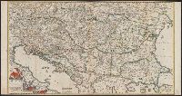
Hungariae et regionum, quae ei quondam fuêre unitae
Description:
Covers Balkan Peninsula south of lat. 50⁰N.
Publisher:
Frederici de Wit,
Subject (Geographic):
Balkan Peninsula--Administrative and political divisions--Maps--Early works to 1800, Balkan Peninsula--Maps--Early works to 1800, and Hungary--Maps--Early works to 1800
Found in:
Beinecke Rare Book and Manuscript Library > Regni Hungariae et regionum, quae ei quondam fuêre unitae, ut Transilvaniae, Valachiae, Moldaviae, Serviae, Romaniae, Bulgariae, Bessarabiae, Croatiae, Bosniae, Dalmatiae, Sclavoniae, Morlachiae, Ragusanae Reipublicae, maximaeq[ue] partis Danubii Flumini
Creator:
Published / Created:
1688
Call Number:
43 1688
Container / Volume:
BRBL_00250
Image Count:
1
Resource Type:
Maps, Atlases & Globes
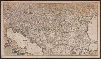
Alternative Title:
Hungariae, et regionum, quae ei quondam fuêre unitae
Description:
Hand colored in outline.
Publisher:
Ex officina Frederici de Wit,
Subject (Geographic):
Balkan Peninsula--Maps--Early works to 1800, Danube River--Maps--Early works to 1800, and Hungary--Maps
Found in:
Beinecke Rare Book and Manuscript Library > Regni Hungariae, et regionum, quae ei quondam fuêre unitae, ut Transilvaniae, Valachiae, Moldaviae, Serviae, Romaniae, Bulgariae, Bessarabiae, Croatiae, Bosniae, Dalmatiae, Sclavoniae, Morlachiae, Ragusanae reipublicae maximaeq partis Danubii fluminis, n
Creator:
Published / Created:
ca. 1680?]
Call Number:
303 1660
Container / Volume:
BRBL_00033
Image Count:
1
Resource Type:
Maps, Atlases & Globes
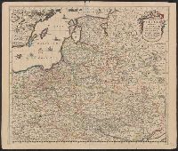
Alternative Title:
Regni Poloniae et Ducatus Lithvaniae Voliniae, Podoliae Vcraniae Prvssiae, Livoniae et Cvrlandiae descriptio
Description:
303 1660: Imperfect: lower left corner chipped, with no loss of text. Sheet measures 53.0 x 62.5 cm.
Publisher:
[Frederik de Wit,
Subject (Geographic):
Baltic States--Maps--Early works to 1800, Belarus--Maps--Early works to 1800, and Poland--Maps--Early works to 1800
Found in:
Beinecke Rare Book and Manuscript Library > Regni Poloniae et Ducatus Lithuaniae Voliniae, Podoliae Ucraniae Prussiae, Livoniae et Curlandiae descriptio [cartographic material] / emendata per F. de Wit.
Creator:
Published / Created:
ca. 1680?]
Call Number:
356 1660
Container / Volume:
BRBL_00113
Image Count:
1
Resource Type:
Maps, Atlases & Globes
Alternative Title:
Regni Poloniae et Ducatus Lithvaniae Voliniae, Podoliae Vcraniae Prvssiae, Livoniae et Cvrlandiae descriptio
Description:
Appears in various editio
Publisher:
[Frederik de Wit,
Subject (Geographic):
Baltic States--Maps--Early works to 1800, Belarus--Maps--Early works to 1800, and Poland--Maps--Early works to 1800
Found in:
Beinecke Rare Book and Manuscript Library > Regni Poloniae et Ducatus Lithuaniae Voliniae, Podoliae Ucraniae Prussiae, Livoniae et Curlandiae descriptio [cartographic material] / emendata per F. de Wit.
Creator:
Published / Created:
[1700?]
Call Number:
39 1700
Image Count:
1
Resource Type:
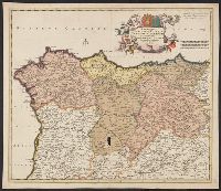
Maps, Atlases & Globes
Publisher:
Ex officina Frederici de Wit,
Subject (Geographic):
Spain, Northern--Maps--Early works to 1800
Found in:
Beinecke Rare Book and Manuscript Library > Regnorum Castellae veteris, legionis, et Gallaeciae, principatuumq[ue] Biscaiae, et Asturiarum, accuratissima descriptio / per F. de Wit.