Skip to search
Skip to main content
Skip to first result
Search
You Searched For
Publication Place
Boston :
Subject (Geographic)
Maine--Maps
Search Results
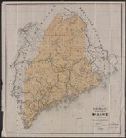
Creator:
Published / Created:
1859
Call Number:
761 1859
Container / Volume:
BRBL_00447
Image Count:
1
Resource Type:
Maps, Atlases & Globes
Description:
Lithographed by Meisel Brothers; surveyed by Shedd & Edson. and State seal on map.
Publisher:
A.J. Coolidge,
Subject (Geographic):
Maine--Maps
Subject (Name):
Meisel Brothers, lithographers and Shedd & Edson
Found in:
Beinecke Rare Book and Manuscript Library > Maine 1859.
Creator:
Published / Created:
[1897?]
Call Number:
761 1897
Container / Volume:
BRBL_00448
Image Count:
1
Resource Type:
Maps, Atlases & Globes
Description:
Relief shown by hachures. and Sheet measures 86.5 x 74 cm.
Publisher:
Geo. H. Walker & Co.,
Subject (Geographic):
Maine--Maps
Subject (Name):
Bangor and Aroostook Railroad Company and Geo. H. Walker & Co
Found in:
Beinecke Rare Book and Manuscript Library > Map of northern Maine : specially adapted to the uses of lumbermen and sportsmen / issued by the Bangor & Aroostook R.R. ; compiled & copyrighted 1897 by Harry A. Frink, C.E.
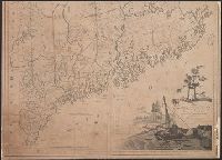
Published / Created:
[1801]
Call Number:
761 1801
Container / Volume:
BRBL_00447
Image Count:
2
Resource Type:
Maps, Atlases & Globes
Description:
Decorative cartouche shows sloop loading lumber off rocky coast; shore with houses, pine tre, London prime mer., and Steel engraving, hand colored to show county lines & U.S.-Can. boundary. Public buildings, mills, factories, roads; certain grants, claims, ect.
Publisher:
J. Callender & S. Hill,
Subject (Geographic):
Maine--Maps
Found in:
Beinecke Rare Book and Manuscript Library > Map of the district of Maine, Massachusetts, compiled from actual surveys made by order of the General Court, and under the inspection of agents of their appointment, by Osgood Carleton.
Creator:
Published / Created:
c1891.
Call Number:
761gme 1891
Container / Volume:
BRBL_00449
Image Count:
1
Resource Type:
Maps, Atlases & Globes
Publisher:
Rand Avery Supply Co., Engr's. ,
Subject (Geographic):
Maine--Maps
Subject (Name):
Allen, William A., C. E, Boothby, E. A, and Robinson, H. C
Subject (Topic):
Railroads--Maine--Maps
Found in:
Beinecke Rare Book and Manuscript Library > Map of the railroads of the state of Maine accompanying the report of the railroad commissioners, 1892 / prepared for the Board of Railroad Commissioners under the direction of William A. Allen ; H.C. Robinson, E.A. Boothby, draughtsmen.
Branch:v1.68.1 ,Deployed:2025-05-28T09:32:28-04:00