"The lands we are now controlling and offering for sale are colored in red.", Cadastral map., Includes text and "Table of land measures.", and Shows surveyed land sections by name or number, proposed line between Bexar and Milam land districts, roads, and creeks.
"The lands we are now controlling and offering for sale are colored in red.", Cadastral map., Includes text and "Table of land measures.", and Shows surveyed land sections by name or number, lands owned by railroad companies, and creeks.
Arkansas and Louisiana, 1931, Principal highways of the Southwest., and Road map of Arkansas and Louisiana
Description:
"Copyright General Drafting Co. Inc"., Includes index and col. logo for "Magnolia Gasoline"., and Map of "Principal highways of the Southwest," directory of vacation places, advertisements, and col. ill. on verso.
Publisher:
Magnolia Petroleum Company,
Subject (Geographic):
Arkansas--Maps and Louisiana--Maps
Subject (Name):
Magnolia Petroleum Company
Subject (Topic):
Roads--Arkansas--Maps, Roads--Louisiana--Maps, and Roads--Southwestern States--Maps
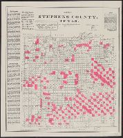
"The lands we are now controlling and offering for sale are colored in red.", Cadastral map., Includes text and "Table of land measures.", and Shows surveyed land sections by name or number, towns, roads, rivers, and creeks.
Publisher:
Daugherty, Connellee & Ammerman,
Subject (Geographic):
Stephens County (Tex.)--Maps
Subject (Name):
August Gast & Co and Daugherty, Connellee & Ammerman
"The lands we are now controlling and offering for sale are colored in red.", Cadastral map., Includes text and "Table of land measures.", and Shows surveyed land sections by name or number, roads, rivers, and creeks.