
You Searched For
« Previous
| 1 - 10 of 13 |
Next »
Search Results
2.

- Creator:
- Russell, John, fl. 1733-1795
- Published / Created:
- 1794 July 26
- Call Number:
- 1986 102
- Collection Title:
- An historical, geographical, commercial, and philosophical view of the American United States, and
- Image Count:
- 1
- Description:
- Engraved by J. Russell, Constitution Row, Grays Inn Lane. and Facing p. 157.
- Publisher:
- Publish'd as the Act directs, by H.D. Symonds, No. 20 Pater Noster Row
- Subject (Geographic):
- America --Description and travel, America --History --To 1810, United States --Description and travel, and United States --Maps --Early works to 1800
- Collection Created:
- London, Printed for the editor; J. Ridgway [etc.] 1795
- Found in:
- Beinecke Rare Book and Manuscript Library > A General map of North America drawn from the best sources
3.
- Published / Created:
- 1776
- Call Number:
- Cb23 27
- Collection Title:
- The American military pocket atlas : being an approved collection of correct maps, both general and
- Image Count:
- 1
- Alternative Title:
- The Seat of war, in the northern colonies, containing the province of Quebec, Newfoundland, Nova-Scotia, New-England, New-York, New-Jersey, Pennsylvania, &ca
- Description:
- 14th August 1776. and Teaching resource: Professor John Mack Faragher, History 141: The American West.
- Publisher:
- Printed for Robt. Sayer & Jno. Bennett, Map and Sea Chartsellers, No. 53, Fleet Street, as the Act directs
- Subject (Geographic):
- New England --Maps --Early works to 1800, North America --Maps --Early works to 1800, and United States --History --Revolution, 1775-1783 --Maps
- Collection Created:
- London : Printed for R. Sayer and J. Bennet, [1776]
- Found in:
- Beinecke Rare Book and Manuscript Library > A General map of the northern British colonies in America. which comprehends the province of Quebec, the government of Newfoundland, Nova-Scotia, New-England and New-York. From the maps published by the Admiralty and Board of Trade regulated by the astronomic and trigonometric observations of M. von Holland and corrected from Governor Pownall's late map 1776.
4.

- Creator:
- Romans, B
- Published / Created:
- 1776
- Call Number:
- Cb23 27
- Collection Title:
- The American military pocket atlas : being an approved collection of correct maps, both general and
- Image Count:
- 1
- Alternative Title:
- The Seat of war, in the southern British colonies, comprehending North and South Carolina, Georgia, east and west Florida, &ca
- Description:
- 15th Oct. 1776., Inset: Plan of Charlestown and plan of St. Augustine., and Teaching resource: Professor John Mack Faragher, History 141: The American West.
- Publisher:
- Printed for R. Sayer & J. Bennett, Map, Chart and Printsellers, No. 53 Fleet Street, as the Act directs
- Subject (Geographic):
- North America --Maps --Early works to 1800, Southern States --Maps --Early works to 1800, and United States --History --Revolution, 1775-1783 --Maps
- Collection Created:
- London : Printed for R. Sayer and J. Bennet, [1776]
- Found in:
- Beinecke Rare Book and Manuscript Library > A General map of the southern British colonies, in America, comprehending North and South Carolina, Georgia, east and west Florida, with the neighbouring Indian countries. From the modern surveys of engineer de Brahm, Capt. Collet, Mouzon & others; and from the large hydrographical survey of the coasts of east and west Florida
5.

- Creator:
- Brasier, William
- Published / Created:
- 1776
- Call Number:
- Cb23 27
- Collection Title:
- The American military pocket atlas : being an approved collection of correct maps, both general and
- Image Count:
- 1
- Description:
- Augst. 5th. 1776., Inset: A particular plan of Lake George. surveyed in 1756. By Capt. Jackson., and Teaching resource: Professor John Mack Faragher, History 141: The American West.
- Publisher:
- Printed for Robt. Sayer & Jno. Bennett, Map & Sea Chartsellers No. 53 Fleet Street, as the Act directs
- Subject (Geographic):
- North America --Maps --Early works to 1800 and United States --History --Revolution, 1775-1783 --Maps
- Collection Created:
- London : Printed for R. Sayer and J. Bennet, [1776]
- Found in:
- Beinecke Rare Book and Manuscript Library > A Survey of Lake Champlain, including Lake George, Crown Point and St. John. Surveyed by order of His Excellency Major General Sr. Jeffery Amherst, knight of the most honble. Order of the Bath, Commander in Chief of His Majesty's forces in North America (now Lord Amherst) by William Brassier, draughtsman, 1762
6.

- Published / Created:
- 1776
- Call Number:
- Cb23 27
- Collection Title:
- The American military pocket atlas : being an approved collection of correct maps, both general and
- Image Count:
- 1
- Alternative Title:
- The Seat of war in the middle British colonies, containing Virginia, Maryland, the Delware counties, &ca
- Description:
- 15th Oct. 1776., Inset: A Sketch of the upper parts of Canada., and Teaching resource: Professor John Mack Faragher, History 141: The American West.
- Publisher:
- Printed for R. Sayer & J. Bennett, Map, Chart & Printsellers, No. 53, Fleet Street, as the Act directs
- Subject (Geographic):
- New England --Maps --Early works to 1800, North America --Maps --Early works to 1800, and United States --History --Revolution, 1775-1783 --Maps
- Collection Created:
- London : Printed for R. Sayer and J. Bennet, [1776]
- Found in:
- Beinecke Rare Book and Manuscript Library > A general map of the middle British colonies in America. Containing Virginia, Maryland, the Delaware counties, Pennsylvania and New Jersey. With the addition of New York, and of the greatest part of New England, as also of the bordering parts of the province of Quebec, improved from several surveys made after the late war, and corrected from Governor Pownall's late map 1776.
7.

- Creator:
- Russell, John, fl. 1733-1795
- Published / Created:
- 1794 October 18
- Call Number:
- 1986 102
- Collection Title:
- An historical, geographical, commercial, and philosophical view of the American United States, and
- Image Count:
- 1
- Description:
- Engraved by J. Russell, Constitution Row Grays Inn Lane. and Facing p. 177.
- Publisher:
- Publish'd as the Act directs, by H.D. Symonds, No. 20 Pater Noster Row
- Subject (Geographic):
- America --Description and travel, America --History --To 1810, Great Britain. Treaties, etc. United States, 1783 Sept. 3, United States --Description and travel, and United States --History --Revolution, 1775-1783 --Maps --Early works to 1800
- Collection Created:
- London, Printed for the editor; J. Ridgway [etc.] 1795
- Found in:
- Beinecke Rare Book and Manuscript Library > An Accurate map of the United States of America. according to the Treaty of Peace of 1783
8.
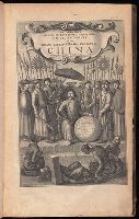
- Creator:
- Nieuhof, Johannes, 1618-1672
- Published / Created:
- 1673
- Call Number:
- 1998 Folio 71
- Image Count:
- 1
- Resource Type:
- Books, Journals & Pamphlets
- Alternative Title:
- [Gezantschap der Neerlandtsche Oost-Indische Compagnie aan den grooten Tartarischen Cham, den tegenwoordigen keizer van China. English]
- Description:
- Imperfect: wanting p. 411-412. Armorial bookplate (motto: Ferro comite): Sr. John Mordaunt.
- Publisher:
- Printed by the Author at his house in White-Friers
- Subject (Geographic):
- China --Description and travel. and Netherlands --Commerce --China
- Found in:
- Beinecke Rare Book and Manuscript Library > An embassy from the East-India Company of the United Provinces, to the Grand Tartar Cham, Emperor of China : deliverd by their excellencies, Peter de Goyer and Jacob de Keyzer, at his imperial city of Peking : wherein the cities, towns, villages, ports, r
9.

- Creator:
- Hall, Sidney
- Published / Created:
- 1822 March
- Call Number:
- Egk30 Ed9 820W
- Collection Title:
- Two years' residence in the settlement on the English prairie, in the Illinois country ... : with
- Image Count:
- 1
- Description:
- Facing p. 310.
- Publisher:
- Published by Longman, Hurst, Rees, Orme & Brown, Paternoster Row
- Subject (Geographic):
- Edwards County (Ill.) and Illinois --Description and travel
- Subject (Topic):
- Frontier and pioneer life --Illinois
- Collection Created:
- London : Longman, Hurst, Rees, Orme, and Brown, 1822
- Found in:
- Beinecke Rare Book and Manuscript Library > Map of Illinois
10.

- Creator:
- Hall, Sidney
- Published / Created:
- 1822 March
- Call Number:
- Egk30 Ed9 820W
- Collection Title:
- Two years' residence in the settlement on the English prairie, in the Illinois country ... : with
- Image Count:
- 1
- Description:
- Following map facing p. 310.
- Publisher:
- Pub. Longman & Co
- Subject (Geographic):
- Edwards County (Ill.) and Illinois --Description and travel
- Subject (Topic):
- Frontier and pioneer life --Illinois
- Collection Created:
- London : Longman, Hurst, Rees, Orme, and Brown, 1822
- Found in:
- Beinecke Rare Book and Manuscript Library > Map of the allotments