Skip to search
Skip to main content
Skip to first result
Search
You Searched For
Genre
Maps
Creator
Great Britain. War Office. General Staff. Geographical Section
Publication Place
London :
New Search
Search Results
Creator:
Published / Created:
1944
Call Number:
331 Ei61 1944
Container / Volume:
BRBL_00080
Image Count:
1
Resource Type:
Maps, Atlases & Globes
Alternative Title:
G.S.G.S. ; 4458 and GSGS (Series) ; 4458.
Description:
Alpha-numeric grid., Copied from a Dutch plan., Important streets and buildings are named., and In upper margin: Holland.
Publisher:
War Office,
Subject (Geographic):
Eindhoven (Netherlands)--Maps
Found in:
Beinecke Rare Book and Manuscript Library > Eindhoven.
Creator:
Published / Created:
1943
Call Number:
343gmp 1943
Container / Volume:
BRBL_00093
Image Count:
1
Resource Type:
Maps, Atlases & Globes
Alternative Title:
Europe (Air) 1:600,000., Geographical Section, General Staff ; no. 4140, and GSGS (Series) ; no. 4140.
Description:
"Northern zone layer system.", Fiber backing., and Relief shown by contour lines, hypsometric tinting and spot heights.
Publisher:
War Office,
Subject (Geographic):
Iceland--Maps
Found in:
Beinecke Rare Book and Manuscript Library > Iceland 1:600,000 Europe (Air), sheet N.W. 63 1/3 24.
Creator:
Published / Created:
1909
Call Number:
6551 1909
Container / Volume:
BRBL_00346
Image Count:
1
Resource Type:
Maps, Atlases & Globes
Alternative Title:
G.S.G.S. ; 2461 and GSGS (Series) ; 2461.
Description:
Alpha-numeric grid., Imperfect: Bled. Bottom left corner wanting., Relief shown by gradient tints., and Tribal names drawn in green.
Publisher:
War Office,
Subject (Geographic):
Nigeria--Maps
Found in:
Beinecke Rare Book and Manuscript Library > Northern Nigeria / compiled in the War Office from boundary commission surveys and road traverses adjusted on certain towns fixed by latitudes and telegraphic longitudes.
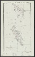
Creator:
Published / Created:
1940
Call Number:
342 1944
Container / Volume:
BRBL_00092
Image Count:
2
Resource Type:
Maps, Atlases & Globes
Alternative Title:
G.S.G.S. ; 4139 and GSGS (Series) ; 4139.
Description:
Contents: North sheet -- South sheet., Contours at 50 meters interval., Copied from a Danish map of 1932., Four classes of roads are shown., and Military grid.
Publisher:
War Office,
Subject (Geographic):
Faroe Islands--Maps
Found in:
Beinecke Rare Book and Manuscript Library > The Faeroes / Drawn at the War Office, 1940, from a Danish map of 1932.
Branch:v1.65.8 ,Deployed:2025-04-02T07:24:48-04:00