Skip to search
Skip to main content
Skip to first result
Search
You Searched For
Extent of Digitization
Completely digitized
Publication Place
London :
Subject (Geographic)
Northeastern States--Maps--Early works to 1800
Search Results
Creator:
Published / Created:
1771
Call Number:
755 1771C
Container / Volume:
BRBL_00429
Image Count:
1
Resource Type:
Maps, Atlases & Globes
Abstract:
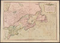
Subject: Map of the central part of the United States showing the middle Atlantic states, and the Ohio River Valley region. Includes anecdotes on the different Indian nations and the lands. Shows dates of settlements and agreements, locations of quarr...
Alternative Title:
Middle British colonies.
Description:
Differs from other copies in extension of the Connecticut River north beyond "Great Falls." Differs also in coloration of boundaries: Ohio River is colored as a boundary: Pennsylvania is shown as extending north to Lake Ontario, etc.
Publisher:
Printed for Carington Bowles,
Subject (Geographic):
Canada--Maps--Early works to 1800, Middle Atlantic States--Maps--Early works to 1800, Northeastern States--Maps--Early works to 1800, and Ohio River Valley--Maps--Early works to 1800
Subject (Name):
Bowles, Carington, 1724-1793, publisher
Subject (Topic):
British--America--Maps--Early works to 1800 and Chron.--1771
Found in:
Beinecke Rare Book and Manuscript Library > A general map of the middle British colonies in America : viz. Virginia, Maryland, Delaware, Pensilvania, New-Jersey, New York, Connecticut & Rhode-Island : of Aquanishuonigy the country of the confederate Indians comprehending Aquanishuonigy proper, thei
Creator:
Published / Created:
1776
Call Number:
755 1776
Container / Volume:
BRBL_00430
Image Count:
1
Resource Type:
Maps, Atlases & Globes
Alternative Title:
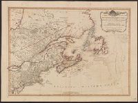
Middle British colonies.
Description:
"The seat of the war in the middle British colonies, containing Virginia, Maryland, the Delaware counties, &ca."
Publisher:
Printed for R. Sayer & J. Bennett, map, chart & printsellers,
Subject (Geographic):
Northeastern States--Maps--Early works to 1800
Subject (Name):
Pownall, Thomas, 1722-1805
Subject (Topic):
British--America--Maps--Early works to 1800
Found in:
Beinecke Rare Book and Manuscript Library > A general map of the middle British colonies, in America [cartographic material] : Containing Virginia, Maryland, the Delaware counties, Pennsylvania and New Jersey. With the addition of New York, and the greatest part of New England, as also of the borde
Published / Created:
12th May, 1794.
Call Number:
71 1794L
Container / Volume:
BRBL_00726
Image Count:
1
Resource Type:
Maps, Atlases & Globes
Description:
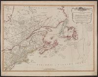
Appears in Laurie & Whittle's New and elegant imperial sheet atlas.
Publisher:
Publish'd by Laurie & Whittle, 53 Fleet Street,
Subject (Geographic):
Canada--Maps--Early works to 1800, Great Britain--Colonies--America--Maps--Early works to 1800, and Northeastern States--Maps--Early works to 1800
Subject (Name):
Robert Laurie and James Whittle and Robert Laurie and James Whittle. New and elegant imperial sheet atlas
Found in:
Beinecke Rare Book and Manuscript Library > A new and correct map of the British colonies in North America comprehending eastern Canada with the province of Quebec, New Brunswick, Nova Scotia, and the Government of Newfoundland [cartographic material] : with the adjacent states of New England, Verm
Published / Created:
12th May, 1794.
Call Number:
71 1794L
Container / Volume:
BRBL_00726
Image Count:
1
Resource Type:
Maps, Atlases & Globes
Description:
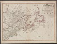
Appears in Laurie & Whittle's New and elegant imperial sheet atlas.
Publisher:
Publish'd by Laurie & Whittle, 53 Fleet Street,
Subject (Geographic):
Canada--Maps--Early works to 1800, Great Britain--Colonies--America--Maps--Early works to 1800, and Northeastern States--Maps--Early works to 1800
Subject (Name):
Robert Laurie and James Whittle and Robert Laurie and James Whittle. New and elegant imperial sheet atlas
Found in:
Beinecke Rare Book and Manuscript Library > A new and correct map of the British colonies in North America comprehending eastern Canada with the province of Quebec, New Brunswick, Nova Scotia, and the Government of Newfoundland [cartographic material] : with the adjacent states of New England, Verm