Skip to search
Skip to main content
Skip to first result
Search
You Searched For
Publication Place
London :
Subject (Geographic)
Europe--Maps
Search Results
Published / Created:
[1941]
Call Number:
36hc 1941A
Container / Volume:
BRBL_00134
Image Count:
1
Resource Type:
Maps, Atlases & Globes
Description:
Includes inset of the Ruhr region.
Publisher:
Ministry of Information,
Subject (Geographic):
Europe--Maps
Subject (Topic):
World War, 1939-1945--Germany--Maps
Found in:
Beinecke Rare Book and Manuscript Library > Allied air offensive against Germany [cartographic material].
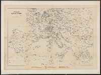
Creator:
Published / Created:
[ca. 1917]
Call Number:
307hc 1917
Container / Volume:
BRBL_00036A
Image Count:
2
Resource Type:
Maps, Atlases & Globes
Description:
Relief shown by hachures. and Shows: international boundaries, railways, roads, naval stations, fortified towns, sea routes.
Publisher:
G.W. Bacon & Co.,
Subject (Geographic):
Europe--Maps and Europe--Politics and government--Maps
Subject (Topic):
World War, 1914-1918--Belgium--Maps, World War, 1914-1918--France--Maps, and World War, 1914-1918--North Sea--Maps
Found in:
Beinecke Rare Book and Manuscript Library > Bacon's map of the seat of war in the North Sea, Belgium and eastern France.
Published / Created:
[1940]
Call Number:
30gm 1940
Container / Volume:
BRBL_00038
Image Count:
1
Resource Type:
Maps, Atlases & Globes
Publisher:
London Geographical Institute,
Subject (Geographic):
Europe--Maps
Found in:
Beinecke Rare Book and Manuscript Library > Central Europe -- Transport Map.
Creator:
Published / Created:
[1890?]
Call Number:
304ag 1890
Container / Volume:
BRBL_00034A
Image Count:
1
Resource Type:
Maps, Atlases & Globes
Description:
Shows railroads and steamer routes.
Publisher:
Thos. Cook & Son,
Subject (Geographic):
Europe--Maps
Subject (Topic):
Railroads--Europe--Maps
Found in:
Beinecke Rare Book and Manuscript Library > Cook's map of central Europe.
Published / Created:
[1874?]
Call Number:
30 1874A
Container / Volume:
BRBL_00032
Image Count:
1
Resource Type:
Maps, Atlases & Globes
Publisher:
C.F. Cruchley,
Subject (Geographic):
Europe--Maps
Found in:
Beinecke Rare Book and Manuscript Library > Cruchley's map of Europe shewing the political divisions and all railways, cities, towns &c.
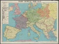
Creator:
Published / Created:
[1941?]
Call Number:
11hd 1939B
Image Count:
1
Resource Type:
Maps, Atlases & Globes
Alternative Title:
Daily express (London, England) and Daily Express war map of Europe
Description:
Prime meridian: Greenwich. and Wall map of wartime Europe showing beligerent countries (United Kingdom, France, Poland, Germany, Danzig, Soviet Russia), neutral countries, the Maginot Line, the Siegfried Line and European wartime resources.
Publisher:
Printed in Great Britain by George Philip & Son,
Subject (Geographic):
Europe--Maps, Maginot Line (France)--Maps, and Siegfried Line (Germany)--Maps
Subject (Topic):
World War, 1939-1945--Europe--Maps
Found in:
Beinecke Rare Book and Manuscript Library > Daily Express war map [cartographic material] / the London Geographical Institute KCL.
Creator:
Published / Created:
1941
Call Number:
11hd 1941
Image Count:
1
Resource Type:
Maps, Atlases & Globes
Alternative Title:
Daily telegraph (London, England), Daily Telegraph war map ; no. 6, Daily Telegraph war map ; no. 6., and War map of the Russian Front
Description:
"Specially prepared for the Daily Telegraph by the London Geographical Institute.", Also shown oil-fields, oil pipe lines, naval bases, railways, canals, and shipping routes., and Wall map showing territories of United Kingdom and "British Empire, Soviet Russia
Publisher:
Printed in Great Britain by George Philip & Son,
Subject (Geographic):
Europe--Maps and Russia (Federation)--Maps
Subject (Topic):
World War, 1939-1945--Eastern front--Maps
Found in:
Beinecke Rare Book and Manuscript Library > Daily Telegraph war map of the Russian Front [cartographic material] / London Geographical Institute.
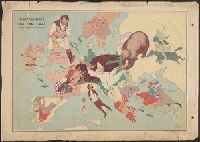
Creator:
Published / Created:
1914
Call Number:
30 1914E
Container / Volume:
BRBL_00032A
Image Count:
1
Resource Type:
Maps, Atlases & Globes
Description:
Caricature map. and Ill. of people and animals represent international relations.
Publisher:
"Geographia" Ltd.,
Subject (Geographic):
Europe--Maps
Subject (Topic):
International relations--20th century--Maps, World War, 1914-1918--Caricatures and cartoons, and World War, 1914-1918--Maps
Found in:
Beinecke Rare Book and Manuscript Library > European revue : kill that eagle / produced by "Geographia" Ltd. ; [drawn by] J.H.A.
Creator:
Published / Created:
[1900]
Call Number:
30 1900
Container / Volume:
BRBL_00032
Image Count:
1
Resource Type:
Maps, Atlases & Globes
Alternative Title:
Serio-comic map of Europe
Description:
Caricature map., Includes text and inset of "Key map of Europe.", National political attitudes are represented by caricatures of people, animals, etc., and Original wrapper pasted on verso. Not digitized.
Publisher:
G.W. Bacon & Co.,
Subject (Geographic):
Europe--Maps and Europe--Politics and government--Maps
Found in:
Beinecke Rare Book and Manuscript Library > John Bull and his friends : a serio-comic map of Europe ... 1900 / by Fred. W. Rose ; Matt. B. Hewerdine from a sketch by Fred. W. Rose.
Published / Created:
1860
Call Number:
30 1860
Container / Volume:
BRBL_00032
Image Count:
1
Resource Type:
Maps, Atlases & Globes
Description:
Table of Souverains; Kingdom, Empire, etc. population, etc. in margin.
Publisher:
Edward Stanford,
Subject (Geographic):
Europe--Maps
Found in:
Beinecke Rare Book and Manuscript Library > L'Europe en 1860.
Branch:v1.68.1 ,Deployed:2025-05-28T09:32:33-04:00