Skip to search
Skip to main content
Skip to first result
Search
You Searched For
Subject (Topic)
Maps
Publication Place
Netherlands Amsterdam
Search Results
Creator:
Published / Created:
ca. 1702?]
Call Number:
1973 Folio 18
Image Count:
1
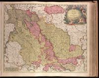
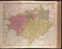
Description:
BEIN 1973 Folio 18: Backed with paper. Ms. no. "36" in upper left-hand corner. Sheet measures 53.6 x 62.8 cm. No. 35 of 87 maps bound together.
Publisher:
Gerard Valk
Subject (Geographic):
North Rhine-Westphalia (Germany) and Limburg (Belgium : Province)
Subject (Topic):
Maps
Found in:
Beinecke Rare Book and Manuscript Library > Archiepiscopatus Coloniensis, ducatibus Iuliacensi et Montensi intermedius queis in septentrionem adjacent Geldria Hispanica, ac comitatus Mursanus / [cartographic material]
Creator:
Published / Created:
[1717]
Call Number:
1973 Folio 18
Image Count:
1
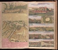
Alternative Title:
Accurate aftekening hoe de twee Legers geleegen hebben voor Belgrado, ent bomberderen en kanonneeren op malkanderen van den 2 tot den 14 Augustus anno 1717
Description:
BEIN 1973 Folio 18: Backed with paper. Ms. no. in upper right corner [illegible due to trimming]. Sheet measures 53.8 x 62.4 cm. No. 74 of 87 maps bound together.
Publisher:
By Gerard van Keulen, aen de Nieuwen Brugh
Subject (Geographic):
Serbia
Subject (Topic):
Austro-Turkish War, 1716-1718 and Maps
Found in:
Beinecke Rare Book and Manuscript Library > Attaque der Turkse galeyen en saiken, op de 2 keyserlyke oorlog scheepen op den 9 July voor gevallen op den Donau [cartographic material].
Creator:
Published / Created:
[ca. 1702?]
Call Number:
1973 Folio 18
Image Count:
1
Description:
BEIN 1973 Folio 18: Backed with paper. Ms. no. "61" in upper right-hand corner. Sheet measures 53.1 x 62.3 cm. No. 56 of 87 maps bound together.
Publisher:
Ger. et Leo. Valk
Subject (Geographic):
Orléanais (France)
Subject (Topic):
Maps
Found in:
Beinecke Rare Book and Manuscript Library > Aurelianensis Praefectura Generalis, in qua partiliter discriminati superiores Ducatus Cenomanensis ... [cartographic material]
Creator:
Published / Created:
ca. 1702]
Call Number:
1973 Folio 18
Image Count:
1
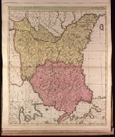
Description:
BEIN 1973 Folio 18: Backed with paper. Ms. no. "82" in upper left corner. Sheet measures 62.5 x 53.7 cm. No. 76 of 87 maps bound together.
Publisher:
Gerard Valk
Subject (Geographic):
Bulgaria, Romania, and Turkey
Subject (Topic):
Maps
Found in:
Beinecke Rare Book and Manuscript Library > Bulgaria et Romania divisa in singulares sangiacatus Silistriam, Nicopolin, Bodinum, Sardiam, Bysantium, Kirkeliam et Gallipolin, una cum finitimis regionibus Valachia, Servia etc. / [cartographic material]
Creator:
Published / Created:
ca. 1702?]
Call Number:
1973 Folio 18
Image Count:
1
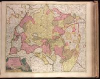
Description:
BEIN 1973 Folio 18: Backed with paper. Ms. no. "34" in upper left-hand corner. Sheet measures 53.6 x 62.9 cm. No. 33 of 87 maps bound together.
Publisher:
Gerard Valk
Subject (Geographic):
Franconia (Germany)
Subject (Topic):
Maps
Found in:
Beinecke Rare Book and Manuscript Library > Circulus Franconicus divisa in Ducatus Coburgi, Franconiae, et Episcopatus Wurtzburgi, Bambergae, et Stadii., Marchionatus Culmbachii, et Onspachii, Comitatus Hennenbergae, Rheineci, Werthemii, Erpachia, Limburgi, Hollae, Suartenburgi, et Castellae / [cartographic material]
Creator:
Published / Created:
ca. 1702?]
Call Number:
1973 Folio 18
Image Count:
1
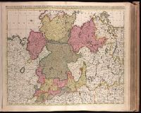
Description:
BEIN 1973 Folio 18: Imperfect: slight stains on verso and recto, with no loss of text. Backed with paper. Ms. no. in upper right corner: 22. Sheet measures 53.7 x 62.8 cm. No. 22 of 87 maps bound together.
Publisher:
Gerard Valck
Subject (Geographic):
Germany, Northern
Subject (Topic):
Maps
Found in:
Beinecke Rare Book and Manuscript Library > Circulus Saxoniae Inferioris, divisa in ducatus Brunsuici, Zellae, Holsatiae, Meklenburgi et Bremae, archiepiscopatum Magdeburgi, et episcopatus Hildesii et Halberstadii [cartographic material]
Creator:
Published / Created:
ca. 1702?]
Call Number:
1973 Folio 18
Image Count:
1
Description:
BEIN 1973 Folio 18: Backed with paper. Ms. no. in upper right corner: 24. Sheet measures 53.7 x 62.7 cm. No. 24 of 87 maps bound together.
Publisher:
Gerard Valck
Subject (Geographic):
Brandenburg (Germany), Saxony (Germany), Saxony-Anhalt (Germany), and Thuringia (Germany)
Subject (Topic):
Maps
Found in:
Beinecke Rare Book and Manuscript Library > Circulus Saxoniae superioris, divisa in ducatus Saxoniae, Altenburgi, Vinariae, Gothae, et Isenaci, principatum Anhaltinum, comitatus Suartenburgi, Barbiae, et Bichlingii, episcoptatius Ceitzii et Halae, cum reliquis ditionibus [cartographic material]
Creator:
Published / Created:
[ca. 1702?]
Call Number:
1973 Folio 18
Image Count:
1
Description:
BEIN 1973 Folio 18: Backed with paper. Ms. no. "28" in upper left-hand corner. Sheet measures 53.7 x 63.0 cm. No. 28 of 87 maps bound together.
Publisher:
Edente Gerardô Valck
Subject (Geographic):
Baden-Württemberg (Germany)
Subject (Topic):
Maps
Found in:
Beinecke Rare Book and Manuscript Library > Circulus Suevicus complectens omnes status subdivisos ex quibus constat [cartographic material].
Creator:
Published / Created:
1706.
Call Number:
1973 Folio 18
Image Count:
1
Description:
BEIN 1973 Folio 18: Backed with paper. Ms. no. "8" in upper right-hand corner. Sheet measures 53.4 x 62.6 cm. No. 7 of 87 maps bound together.
Publisher:
Peter Schenk
Subject (Geographic):
Denmark and Germany, Northern
Subject (Topic):
Maps
Found in:
Beinecke Rare Book and Manuscript Library > Dania regnum ducatus Holsatia et Slesvicum insulae Danicae et provinciae Iutia Scania etc. / [cartographic material]
Creator:
Published / Created:
[1734]
Call Number:
1973 Folio 18
Image Count:
1
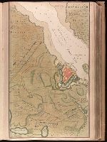
Description:
BEIN 1973 Folio 18: Backed with paper. Ms. no. "13" in upper right-hand corner. Sheet measures 53.6 x 35.5 cm. No. 13 of 87 maps bound together.
Publisher:
By Gerard van Keulen ...
Subject (Geographic):
Rügen Island (Germany), Stralsund (Germany), and Baltic Sea
Subject (Topic):
Northern War, 1700-1721, Maps, and Nautical charts
Found in:
Beinecke Rare Book and Manuscript Library > De kust van Pomeren, hey eyland Rugen [cartographic material].