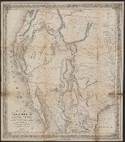
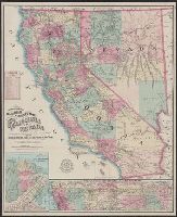
Gibbes' map of the state of California and Map of the United States of America, Mexico, Central America, Cuba &c.
Description:
Inset: Map of the United States of America, Mexico, Central America, Cuba &c. Scale [ca. 1:13,000,000] (W 128⁰--W 65⁰/N 49⁰--N 6⁰)., Presentation inscription: Charles D Gibbes [rubber stamped] to George Davidson, Jany 11/87., and Prime meridians: Greenwich and Washington.
Publisher:
C.D. Gibbes : and Sherman & Smith,
Subject (Geographic):
California--Maps
Subject (Name):
Davidson, George,--1825-1911.--Presentation inscription from C.D. Gibbes, Gibbes, Charles Drayton.--Presentation inscription to G. Davidson, and Sherman & Smith
"Entered according to act of Congress in the year 1855 by J.H. Colton in the clerks office of the district court for the southern district of New York.", "No. 52.", Includes inset of "City of San Francisco.", Relief shown by hachures and spot heights., and Text on verso: The territories of Oregon and Washington.
Tanner's travelling map of California &c, Travelling map of California, and United States, Mexico &c, showing the routes from N. York to St. Francisco by land & water.
Description:
Includes inset of "United States, Mexico &c, showing the routes from N. York to St. Francisco by land & water.", Library's copy 2 mounted on linen, without cover., Relief shown by hachures., Shows the New Southwest and parts of Texas and Mexico., and Text inside front cover, "Table of routes from New-York to California with the modes of conveyance, distances, time and fares."
Publisher:
H.S. Tanner,
Subject (Geographic):
California--Gold discoveries--Maps, California--Maps, Mexico--Maps, and Southwest, New--Maps
"Entered according to act of Congress in the year 1849 by J.H. Colton in the clerk's office of the district court for the southern district of New York.", In bottom margin: Appleton & Co. New York., Includes text and distance table., and Prime meridians: Greenwich and Washington.
Map of the city of San Francisco, California., Map of the Great National Pacific Railroads., and Topographical railroad and county map of the states of California and Nevada
Description:
"Entered according to act of Congress A.D. 1868 by Frey & Nell in the clerks office of the district court of the United States for the southern district of New York." and Includes insets of "Map of the city of San Francisco, California" and "Map of the Great National Pacific Railroads," distance list, and difference of time chart.
Publisher:
A.C. Frey & Co. ; and General agents for California, A. Roman & Co.,
Subject (Geographic):
California--Maps, Nevada--Maps, and San Francisco (Calif.)--Maps
Subject (Name):
A. Roman & Co, A.C. Frey & Co, and Ferd. Mayer & Co