Skip to search
Skip to main content
Skip to first result
Search
You Searched For
Format
cartographic
Publication Place
Paris :
New Search
Search Results
Published / Created:
[1859]
Call Number:
40hc 1859F
Container / Volume:
BRBL_00231
Image Count:
1
Resource Type:
Maps, Atlases & Globes
Publisher:
Bulla Frères, and Goupil & Co. ;
Subject (Geographic):
Italy, Northern--Maps
Found in:
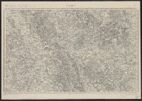
Beinecke Rare Book and Manuscript Library > Théâtre de la guerre en Italie : Vue prise a vol d'oiseau au dessus de Grenoble / Dessiné par Ph. Benoist ; Lith. par Eug. Cicéri.
Creator:
Published / Created:
[1904?]
Call Number:
5615 1900
Container / Volume:
BRBL_00299
Image Count:
1
Resource Type:
Maps, Atlases & Globes
Alternative Title:
Pei-Tché-Li
Description:
"11.34.", "Extrait de la carte de l'Asie au 1.000.000e.", Includes glossary., and Relief shown by shading.
Publisher:
Service géographique de l'Armée,
Subject (Geographic):
Beijing Region (China)--Maps and China--History--Boxer Rebellion, 1899-1901--Maps
Found in:
Beinecke Rare Book and Manuscript Library > Théâtre des opérations en Chine [cartographic material] : Pei-Tché-Li / dressé, héliogravé, et publié par le Service géographique de l'Armée (juillet 1900).
Creator:
Published / Created:
[1918?]
Call Number:
53 1926
Container / Volume:
BRBL_00285
Image Count:
1
Resource Type:
Maps, Atlases & Globes
Description:
Includes 2 inset maps: [Continuation west] -- [Location map].
Publisher:
A. Taride,
Subject (Geographic):
Asia, Central--Maps, Caucasus--Maps, Egypt--Maps, Iran--Maps, and Turkey--Maps
Found in:
Beinecke Rare Book and Manuscript Library > Turquie d'Asie [cartographic material] : Caucase, Perse, Egypte / A. Taride, éditeur.
Creator:
Published / Created:
1917
Call Number:
38315cbf V585 1913
Container / Volume:
BRBL_00177
Image Count:
1
Resource Type:
Maps, Atlases & Globes
Description:
"R.21.5.17.", "Revisée en 1913.", and Original publication details printed in lower margin: Levée par les Officiers du Corps d'Etat-Major, et publiée par le Dépôt de la Guerre en 1835. Gravée le trait par Thierry, la lettre par Hacq, le figure du terrain
Publisher:
Corps d'état major,
Subject (Geographic):
Lorraine (France)--Maps and Verdun (France)--Maps
Subject (Name):
Dépôt de la guerre (France)
Subject (Topic):
World War, 1914-1918--France--Lorraine
Found in:
Beinecke Rare Book and Manuscript Library > Verdun.
Creator:
Published / Created:
ca. 1919]
Call Number:
38gmb P21 1915
Container / Volume:
BRBL_00171
Image Count:
1
Resource Type:
Maps, Atlases & Globes
Description:
"Gravé chez L. Wuhrer ... Paris."
Publisher:
[s.n.,
Subject (Geographic):
Paris (France)--Maps
Found in:
Beinecke Rare Book and Manuscript Library > Voies publiques de Paris [cartographic material].
Creator:
Published / Created:
[1864?]
Call Number:
62 1864
Container / Volume:
BRBL_00333
Image Count:
11
Resource Type:
Maps, Atlases & Globes
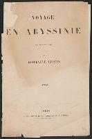
Description:
[Map] I: Halaï -- II: Koarata -- III: Adoua -- V: Takazzé -- VI: Lamalmon -- VII: Gondar -- VIII: Devra Tabor -- IX: Goundet -- X: Amidamit -- XI: Mizan -- XIII [i.e., XII]: Partie de la route de Zenadegle. and Cover title.
Publisher:
L. Hachette et Cie, Libraires-Éditeurs, Boulevard Saint-Germain 79,
Subject (Geographic):
Ethiopia--Atlases and Ethiopia--Maps
Found in:
Beinecke Rare Book and Manuscript Library > Voyage en Abyssinie [cartographic material] : executé de 1862 a 1864 / par Guillaume Lejean.
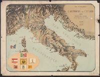
Published / Created:
1859
Call Number:
40hc 1859G
Container / Volume:
BRBL_00231
Image Count:
1
Resource Type:
Maps, Atlases & Globes
Description:
In bottom margin: "a Lyon chez Gadola".
Publisher:
Gosselin,
Subject (Geographic):
Italy--Maps
Found in:
Beinecke Rare Book and Manuscript Library > Vue panoramique de L'Autriche & de L'Italie : Théâtre de la Guerre / Dessinée et Lithographièe par L. Lebreton.
Creator:
Published / Created:
[1954]
Call Number:
38eb 1954A
Container / Volume:
BRBL_00170
Image Count:
9
Resource Type:
Maps, Atlases & Globes
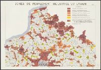
Description:
"Exécutée par l'Imprimerie Nationale sur fond de carte du Ministère de la Construction.", Date from data in legend., and Includes index maps on each sheet and inset: Corse, on sheet 9.
Publisher:
Imprimerie Nationale,
Subject (Geographic):
France--Population--Maps
Subject (Topic):
Industries--France--Maps, Metropolitan areas--France--Maps, and Urbanization--France--Maps
Found in:
Beinecke Rare Book and Manuscript Library > Zones de peuplement industriel ou urbain [cartographic material] / Carte établie par l'I.N.S.E.E.
Published / Created:
[1890?].
Call Number:
38gmb P21 1870
Container / Volume:
BRBL_00171
Image Count:
1
Resource Type:
Maps, Atlases & Globes
Description:
In upper right margin: "Pl. 6"., Legend indicates roadwork from 1850 to 1870, and after 1870., and Title supplied by cataloger.
Publisher:
L. Wuhrer,
Subject (Geographic):
Paris (France)--Maps
Found in:
Beinecke Rare Book and Manuscript Library > [Principales opérations de voirie exécutées à Paris].
Published / Created:
19--?]
Call Number:
11hcf 1919-8
Container / Volume:
BRBL_00010M
Image Count:
2
Resource Type:
Maps, Atlases & Globes
Alternative Title:
Distribution of forces in Russia
Description:
Map page from Atlas VIDAL-LABLACHE. Shows "Allied forces in black. Bolshevist forces in blue" with corresponding ms. notes on map. Ms. notes detail nationalities and commanders of individual forces and their placement. Map text in French, ms. notes in Eng
Publisher:
A. Colin,
Subject (Geographic):
Russia--Maps
Found in:
Beinecke Rare Book and Manuscript Library > [Russie Carte Politique.]
Branch:v1.65.8 ,Deployed:2025-04-02T07:25:24-04:00