1.

- Creator:
- Ringgold, Cadwalader, 1802-1867
- Published / Created:
- [1851?]
- Call Number:
- 844cea Sa52 1850C
- Container / Volume:
- BRBL_00614
- Image Count:
- 1
- Resource Type:
- Maps, Atlases & Globes
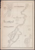
- Description:
- "Constructed, projected and drawn by Fred D. Stuart, hydrographer, late of the U.S. Ex. Ex. ; assisted by John Tyssowski, draughtsman., "Entered according to act of Congress in the year 1851 by Cadwalader Ringgold ....", "Sheet no. 3.", and Inset views: View of Benicia from the anchorage east of Seal Island -- Mark for Tongue Shoal -- Entrance to the Sacramento River.
- Publisher:
- C.B. Graham, Lithr.,
- Subject (Geographic):
- Sacramento River (Calif.)--Maps, San Joaquin River (Calif.)--Maps, and Suisun Bay (Calif.)--Maps
- Subject (Name):
- Graham, C. B. (Curtis B.), Humphreys, William P. (William Penn), Knox, Samuel R, Rowe, J. H, Stuart, Fred D, and Tyssowski, John
- Subject (Topic):
- Nautical charts--California--Sacramento River, Nautical charts--California--San Joaquin River, and Nautical charts--California--Suisun Bay
- Found in:
- Beinecke Rare Book and Manuscript Library > Chart of Suisun & Vallejo Bays, with the confluence of the rivers Sacramento and San Joaquin : California / by Cadwalader Ringgold, Commander, U.S. Navy ; assisted by Sam. R. Knox, Lieut., U.S.N. and Wm. P. Humphreys & J.H. Rowe, engineers, 1850.