Skip to search
Skip to main content
Skip to first result
Search
You Searched For
Genre
Maps
Creator
United States. General Land Office
Publication Place
Washington, D.C. :
New Search
Search Results
Creator:
Published / Created:
1864
Call Number:
75fcm 1864
Container / Volume:
BRBL_00410
Image Count:
1
Resource Type:
Maps, Atlases & Globes
Description:
Relief shown by hachures. and Taken from the General Land Office report of 1864.
Publisher:
D. McClelland,
Subject (Geographic):
Canada--Boundaries--United States--Maps
Subject (Name):
Franks, Theodore, Hawes, James W. (James William), 1844-1918, and McClelland, D
Subject (Topic):
Public lands --United States and Public lands--United States--Maps.
Found in:
Beinecke Rare Book and Manuscript Library > Map of the Public Land States and territories [cartographic material] / constructed from the Public Surveys and other official sources in the General Land Office ; drawn by J.H. Hawes, principal draughtsman [and] T. Franks, assistant.
Creator:
Published / Created:
1910
Call Number:
834 1910A
Container / Volume:
BRBL_00588
Image Count:
1
Resource Type:
Maps, Atlases & Globes
Description:
"Note: Medicine Bow National Forest now Colorado National Forest. Las Animas National Forest now part of San Isabel National Forest.", Insets: Leadville -- City of Denver -- Cripple Creek., Relief shown by shading., and Shows United States reclamation projects.
Publisher:
Supt. of Docs., G.P.O.,
Subject (Geographic):
Colorado--Maps
Subject (Name):
Dinsmore, A. F
Subject (Topic):
Forest reserves--Colorado--Maps
Found in:
Beinecke Rare Book and Manuscript Library > State of Colorado : compiled from the official records of the General land office and other sources / compiled by A.F. Dinsmore ; traced and lettered by Wm. Bauman Jr., U.S. General Land Office.
Creator:
Published / Created:
1907
Call Number:
832 1907
Container / Volume:
BRBL_00582
Image Count:
1
Resource Type:
Maps, Atlases & Globes
Abstract:
Shows township, railroad & county lines, forest, military & Indian reservations, etc.
Description:
Insets: Boise and vicinity -- Pocatello and vicinity -- Wallace and vicinity -- Lewiston and vicinity., Prime meridians: Greenwich and Washington., and Relief shown by shading.
Publisher:
General Land Office,
Subject (Geographic):
Idaho--Maps
Subject (Name):
Andrew B. Graham Co, Bond, Frank, 1856-1940, and Helm, Charles J
Found in:
Beinecke Rare Book and Manuscript Library > State of Idaho : 1907 / compiled from the official records of the General Land Office and other sources under the direction of Frank Bond ; rev. & drawn by Charles J. Helm.
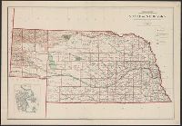
Creator:
Published / Created:
1908
Call Number:
824 1908
Container / Volume:
BRBL_00570
Image Count:
1
Resource Type:
Maps, Atlases & Globes
Description:
Includes inset of "City of Omaha.", Relief shown by shading., and Shows railroads, national forests, and military and Indian reservations.
Publisher:
Andrew B. Graham Company, lithographers,
Subject (Geographic):
Nebraska--Maps
Subject (Name):
Bauman, Wm. (William), Berthrong, I. P, and Dinsmore, A. F
Found in:
Beinecke Rare Book and Manuscript Library > State of Nebraska / Department of the Interior, General Land Office ; compiled from the official records of the General Land Office and other sources under the direction of I.P. Berthrong ; compiled by A.F. Dinsmore ; traced and lettered by Wm. Bauman, Jr
Branch:v1.65.8 ,Deployed:2025-04-06T22:41:55-04:00