
You Searched For
« Previous
| 1 - 10 of 21 |
Next »
Search Results
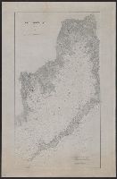
2.

- Creator:
- United States. Hydrographic Office
- Published / Created:
- 1904
- Call Number:
- 556cea 1904
- Container / Volume:
- BRBL_00293
- Image Count:
- 1
- Resource Type:
- Maps, Atlases & Globes
- Alternative Title:
- Charts, etc.
- Description:
- "No. 2156." and Mounted on linen.
- Publisher:
- Hydrographic Office,
- Subject (Geographic):
- China--Maps, Japan--Maps, and Korea--Maps
- Found in:
- Beinecke Rare Book and Manuscript Library > Asia, Japan and Korea : with the surrounding seas and the adjacent coastal region of China / published at Washington, D.C. Feb. 1904, at the Hydrographic Office. H.M. Hodges, Lieutenant Commander, U.S.N. Hydrographer.
3.
- Published / Created:
- 1883
- Call Number:
- 764cea B65 1883A
- Container / Volume:
- BRBL_00461
- Image Count:
- 1
- Resource Type:
- Maps, Atlases & Globes
- Description:
- Shows location of buoys and soundings in fathoms.
- Publisher:
- U.S. Coast Survey,
- Subject (Geographic):
- Boston Harbor (Mass.)--Maps
- Found in:
- Beinecke Rare Book and Manuscript Library > Boston Bay and Harbor, Massachusetts. / United States Coast Survey.
4.
- Published / Created:
- 1883
- Call Number:
- 764cea B98 1883
- Container / Volume:
- BRBL_00461
- Image Count:
- 1
- Resource Type:
- Maps, Atlases & Globes
- Description:
- Shows location of buoys and soundings in fathoms.
- Publisher:
- U.S. Coast Survey,
- Subject (Geographic):
- Buzzard's Bay (Mass.)--Maps
- Found in:
- Beinecke Rare Book and Manuscript Library > Buzzard's Bay [Massachusetts] / United States Coast Survey.
5.
- Creator:
- Maury, Matthew Fontaine, 1806-1873
- Published / Created:
- 1852
- Call Number:
- 11cfk 1850C-9
- Container / Volume:
- BRBL_00772
- Image Count:
- 2
- Resource Type:
- Maps, Atlases & Globes
- Alternative Title:
- [Maury map collection ; Series C1] and Pilot chart, Cape Horn
- Description:
- "Series C.", Copy imperfect: Sheets 1 and 2 torn and repaired along fold-line on tracing paper., DLC, Each sheet numbered in upper left margin, e.g.: 117, 118., Includes diagrams and a note in map area with signature of M.F. Maury., and Shows prevailing wind direc
- Publisher:
- United States Hydrographical Office,
- Subject (Geographic):
- Horn, Cape, Region (Chile)--Maps
- Subject (Name):
- Maury, Matthew Fontaine, 1806-1873. Wind and current charts, Morris, Charles, 1784-1856, United States Naval Observatory, United States. Bureau of Ordnance and Hydrography, and United States. Hydrographic Office
- Subject (Topic):
- Nautical charts--Chile--Horn, Cape, Region, Ocean currents--Chile--Horn, Cape, Region--Maps, and Winds--Chile--Horn, Cape, Region--Maps
- Found in:
- Beinecke Rare Book and Manuscript Library > Pilot chart for Cape Horn [cartographic material] / by M.F. Maury, L.L.D. Lieut. U.S. Navy, Superin'dt. of U.S.N. Observatory ; compiled from materials in the Bureau of Ordnance and Hydrography, Commodore Charles Morris, Chief of Bureau.
6.
- Creator:
- Maury, Matthew Fontaine, 1806-1873
- Published / Created:
- 1852
- Call Number:
- 11cfk 1850C-9
- Container / Volume:
- BRBL_00772
- Image Count:
- 2
- Resource Type:
- Maps, Atlases & Globes
- Alternative Title:
- [Maury map collection ; Series C1] and Pilot chart, Cape Horn
- Description:
- "Series C.", Copy imperfect: Sheets 1 and 2 torn and repaired along fold-line on tracing paper., DLC, Each sheet numbered in upper left margin, e.g.: 117, 118., Includes diagrams and a note in map area with signature of M.F. Maury., and Shows prevailing wind direc
- Publisher:
- United States Hydrographical Office,
- Subject (Geographic):
- Horn, Cape, Region (Chile)--Maps
- Subject (Name):
- Maury, Matthew Fontaine, 1806-1873. Wind and current charts, Morris, Charles, 1784-1856, United States Naval Observatory, United States. Bureau of Ordnance and Hydrography, and United States. Hydrographic Office
- Subject (Topic):
- Nautical charts--Chile--Horn, Cape, Region, Ocean currents--Chile--Horn, Cape, Region--Maps, and Winds--Chile--Horn, Cape, Region--Maps
- Found in:
- Beinecke Rare Book and Manuscript Library > Pilot chart for Cape Horn [cartographic material] / by M.F. Maury, L.L.D. Lieut. U.S. Navy, Superin'dt. of U.S.N. Observatory ; compiled from materials in the Bureau of Ordnance and Hydrography, Commodore Charles Morris, Chief of Bureau.
7.
- Creator:
- Maury, Matthew Fontaine, 1806-1873
- Published / Created:
- 1851-1859.
- Call Number:
- 11cfk 1850C-6
- Container / Volume:
- BRBL_00771
- Image Count:
- 10
- Resource Type:
- Maps, Atlases & Globes
- Alternative Title:
- [Maury map collection ; Series C9] and South Pacific
- Description:
- Includes diagrams and notes in map area with signature of M.F. Maury. and Multiple copies and varying editions of some sheets: Sheet 1 (1859) -- Sheet 1 (1853) -- Sheet 2 [1856] -- Sheet 2 [1853] -- Sheet 3 (1856, 2nd ed.) -- Sheet 5 [1856] -- Sheet 6 (1851),
- Publisher:
- United States Hydrographical Office,
- Subject (Geographic):
- South Pacific Ocean--Charts, diagrams, etc
- Subject (Name):
- Maury, Matthew Fontaine, 1806-1873. Wind and current charts, United States Naval Observatory, United States. Bureau of Ordnance and Hydrography, and United States. Hydrographic Office
- Subject (Topic):
- Marine meteorology--Oceania--Charts, diagrams, etc, Nautical charts--Oceania, Pilot guides--Oceania--Charts, diagrams, etc, and Winds--Oceania--Charts, diagrams, etc
- Found in:
- Beinecke Rare Book and Manuscript Library > Pilot chart of the South Pacific [cartographic material] / by M.F. Maury, L.L.D., Lieut. U.S. Navy ; Superin'dt. of U.S.N. Observatory ; compiled from materials in the Bureau of Ordnance and Hydrography, Commodre Charles Morris, Chief of Bureau.
8.
- Creator:
- Maury, Matthew Fontaine, 1806-1873
- Published / Created:
- 1854
- Call Number:
- 11cfk 1850C-8
- Container / Volume:
- BRBL_00772
- Image Count:
- 1
- Resource Type:
- Maps, Atlases & Globes
- Alternative Title:
- [Maury map collection ; Series C3] and Coast of Brazil
- Description:
- "Series C.", "This chart is on the plan of Pilot Chart North Atlantic. The onl, Copy imperfect: Discoloration throughout. Mounted on cloth., DLC, Includes a diagram and a note in map area with signature of M.F. Maury., and Shows prevailing wind direction by month.
- Publisher:
- United States Hydrographical Office,
- Subject (Geographic):
- Atlantic Coast (Brazil)--Maps
- Subject (Name):
- Maury, Matthew Fontaine, 1806-1873. Wind and current charts, Sherman & Smith, United States Naval Observatory, United States. Bureau of Ordnance and Hydrography, and United States. Hydrographic Office
- Subject (Topic):
- Coasts--Brazil--Maps, Nautical charts--Brazil--Atlantic Coast, and Winds--Brazil--Atlantic Coast--Maps
- Found in:
- Beinecke Rare Book and Manuscript Library > Pilot chart of the coast of Brazil [cartographic material] / by Lieut. M.F. Maury, U.S. Navy, National Observatory ; eng. by Sherman & Smith.
9.
- Creator:
- Maury, Matthew Fontaine, 1806-1873
- Published / Created:
- 1855
- Call Number:
- 11cfk 1850C-11
- Container / Volume:
- BRBL_00772
- Image Count:
- 1
- Resource Type:
- Maps, Atlases & Globes
- Alternative Title:
- [Maury map collection ; Series C5] and North Indian Ocean
- Description:
- "Series C. nos. 1 & 2.", Copy imperfect: Torn fold-lined with minor losses. Torn and repaired along right edge. Mounted on cloth., Shows prevailing wind direction by month., and The pilot charts were released as series C a part of Maury's "Wind and current chart
- Publisher:
- United States Hydrographical Office,
- Subject (Geographic):
- Indian Ocean--Maps
- Subject (Name):
- Fitzgerald, W. B, Maury, Matthew Fontaine, 1806-1873. Wind and current charts, Morris, Charles, 1784-1856, United States Naval Observatory, United States. Bureau of Ordnance and Hydrography, United States. Hydrographic Office, and West, Wm. C. (William C.)
- Subject (Topic):
- Nautical charts--Indian Ocean and Winds--Indian Ocean--Maps
- Found in:
- Beinecke Rare Book and Manuscript Library > Pilot chart of the north Indian Ocean [cartographic material] / by M.F. Maury, L.L.D. Lieut. U.S. Navy, Superin'dt. of U.S.N. Observatory ; compiled from materials in the Bureau of Ordnance and Hydrography by Lieuts. W.B. Fitzgerald & Wm. C. West, U.S.N, Commodore Charles Morris, Chief of Bureau.
10.
- Creator:
- Maury, Matthew Fontaine, 1806-1873
- Published / Created:
- 1855
- Call Number:
- 11cfk 1850C-11
- Container / Volume:
- BRBL_00772
- Image Count:
- 1
- Resource Type:
- Maps, Atlases & Globes
- Alternative Title:
- [Maury map collection ; Series C5] and North Indian Ocean
- Description:
- "Series C. nos. 1 & 2.", Copy imperfect: Torn fold-lined with minor losses. Torn and repaired along right edge. Mounted on cloth., DLC, and The pilot charts were released as series C a part of Maury's "Wind and current charts", series A-F. These charts were desi
- Publisher:
- United States Hydrographical Office,
- Subject (Geographic):
- Indian Ocean--Maps
- Subject (Name):
- Fitzgerald, W. B, Maury, Matthew Fontaine, 1806-1873. Wind and current charts, Morris, Charles, 1784-1856, United States Naval Observatory, United States. Bureau of Ordnance and Hydrography, United States. Hydrographic Office, and West, Wm. C. (William C.)
- Subject (Topic):
- Nautical charts--Indian Ocean and Winds--Indian Ocean--Maps
- Found in:
- Beinecke Rare Book and Manuscript Library > Pilot chart of the north Indian Ocean [cartographic material] / by M.F. Maury, L.L.D. Lieut. U.S. Navy, Superin'dt. of U.S.N. Observatory ; compiled from materials in the Bureau of Ordnance and Hydrography by Lieuts. W.B. Fitzgerald & Wm. C. West, U.S.N, Commodore Charles Morris, Chief of Bureau.