Copyright, 1909, by the J.N. Matthews Co., Buffalo, N.Y., Relief shown by hachures and spot heights., and Suppl. to The National Geographic Magazine, March 1909.
Publisher:
National Geographic Society,
Subject (Geographic):
Africa--Maps
Subject (Name):
Grosvenor, Gilbert Hovey, 1875-1966, J.N. Matthews Co, and National Geographic Society (U.S.)
Bouma, Donald G Brehm, John J. B Darley, James M. (James Morrison) Holdstock, A. E National Geographic Society (U.S.). Cartographic Division
Published / Created:
1945
Call Number:
28 1945
Container / Volume:
BRBL_00023E
Image Count:
1
Resource Type:
Maps, Atlases & Globes
Description:
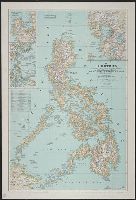
Copy 1: Mounted on linen., Insets: Location map of the Philippines. Scale 1:40,000,000 -- Lingayen, Table: Philippine provinces and their capital cities., and Topographic map with relief shown by hachures and spot heights; elevations and depths in feet.
United States. Bureau of Naval Personnel. Educational Services Section
Published / Created:
1944
Call Number:
5819hc 1944
Container / Volume:
BRBL_00314
Image Count:
4
Resource Type:
Maps, Atlases & Globes
Alternative Title:
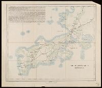
Nav war map ; no. 2, Nav war map ; no. 2., and NavWarMap No. 2 :
Description:
Imperfect: Torn along fold lines., Includes text, ill., and chronology of America's relations with Southeast Asia., Inset: Air and sea distances are vast., Pictorial map., and Relief shown by shading.
Publisher:
Distributed by Educational Services Section, Bureau of Naval Personnel, Navy Dept.,
Subject (Topic):
World War, 1939-1945--South China Sea--Naval operations, American--Maps
National Geographic Society (U.S.). Cartographic Division
Published / Created:
1982
Call Number:
7821 1982
Container / Volume:
BRBL_00506
Image Count:
2
Resource Type:
Maps, Atlases & Globes
Alternative Title:
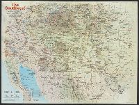
Making of America, the Southwest
Description:
"Supplement to the National Geographic, November 1982, page 630A, Vol. 162, No. 5.", Relief shown by shading and spot heights., and Text, ill., and maps of early Indian occupancy, Spanish Conquest 1540-1820, Anglo-American entry and occupancy 1820-1900, and the
Publisher:
The Society,
Subject (Geographic):
America--Discovery and exploration--Spanish--Maps, Southwest, New--History--Maps, and Southwest, New--Maps
"L. Olszewski, Washington, D.C." in bottom left margin., "U.S. Treasury, Bureau of Statistics" in bottom center margin., and Siganture "O.P. Austin, Chief of Bureau" in bottom right margin.
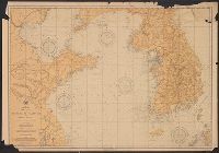
Asia, China and Korea : and Hwang Hai or Yellow Sea and Gulf of Pechili
Description:
"Compiled by E.E. Court and H.P. Simpson. Lithographed by Gr. Noetzel. No. 1443"--Lower right, "Division of Chart Construction, G.W. Littlehales, Assistant in Charge."--Lower left margin., and Relief shown by shading and spot heights. Depths shown by soundings.
Publisher:
Hydrographic Office, Bureau of Navigation, Dept. of the Navy,
Subject (Geographic):
Bo Hai (China)--Maps, Korea--Maps, and Yellow Sea--Maps
Subject (Name):
Court, E. E, Noetzel, Gregor, Simpson, H. P, United States. Hydrographic Office. Division of Chart Construction, and United States. Navy Dept. Bureau of Navigation
Subject (Topic):
Nautical charts--China--Bo Hai, Nautical charts--Korea, and Nautical charts--Yellow Sea