Skip to search
Skip to main content
Skip to first result
Search
You Searched For
Format
cartographic
Publication Place
Washington, D.C. :
New Search
Search Results
Creator:
Published / Created:
1945
Call Number:
56 T83 1945
Container / Volume:
BRBL_00297
Image Count:
1
Resource Type:
Maps, Atlases & Globes
Alternative Title:
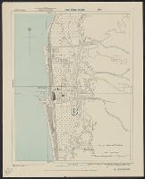
Eastern China 1:50,000 : Tungchow and G.S.G.S. ; 3789
Description:
"Sheet 19/2,200"--Upper right margin., "Tungchow N3950-E11631/11x21"--Lower right margin., Includes legend., and Relief is shown by contours.
Publisher:
Army Map Service,
Subject (Geographic):
Tong Zhou (Beijing, China)--Maps
Subject (Name):
United States. Army Map Service
Found in:
Beinecke Rare Book and Manuscript Library > Tungchow [cartographic material] / Geographical Section, General Staff.
Creator:
Published / Created:
1943
Call Number:
501 1943
Container / Volume:
BRBL_00276
Image Count:
1
Resource Type:
Maps, Atlases & Globes
Alternative Title:
Geographic Section, General Staff ; no. 4292 and GSGS (Series) ; 4292.
Description:
Elevation shown by contour lines and spot heights in meters., Importance of cities symbolized by print size., and Railroad lines are identicated.
Publisher:
Army Map Service, U.S. Army,
Subject (Geographic):
Turkey--Maps
Subject (Name):
United States. Army Map Service
Found in:
Beinecke Rare Book and Manuscript Library > Turkey [cartographic material].
Creator:
Published / Created:
1943
Call Number:
352 1943A
Container / Volume:
BRBL_00106
Image Count:
1
Resource Type:
Maps, Atlases & Globes
Alternative Title:
G.S.G.S. ; 3953, Great Britain. Army. Middle East Forces. M.D.R. ; 498, GSGS (Series) ; 3953., and M.D.R. ; 498
Description:
"Conical orthomorphic projection with two standard parallels 27⁰ and 63⁰ N. lat.", Gt. Brit. War office. General staff. Geographical section. Provisional G.S.G.S. 3953., and Transportation map of European Russia.
Publisher:
Army Map Service,
Subject (Geographic):
Soviet Union--Maps
Subject (Topic):
Transportation--Soviet Union--Maps
Found in:
Beinecke Rare Book and Manuscript Library > U.S.S.R. and adjacent countries / Compiled and ... revised ... by 512 Fd. survey coy., R.E. ...
Creator:
Published / Created:
c1944.
Call Number:
35 1944
Container / Volume:
BRBL_00101
Image Count:
1
Resource Type:
Maps, Atlases & Globes
Description:
Copy 1: Mounted on linen.
Publisher:
National Geographic Society,
Subject (Geographic):
Soviet Union--Maps
Found in:
Beinecke Rare Book and Manuscript Library > Union of Soviet Socialist Republics International boundaries according to Russian treaties and claims as of October 1, 1944 ; Boundaries of January 1, 1938, are shown in red Compiled and drawn in the Cartographic Section of the National Geographic Society
Creator:
Published / Created:
c1944.
Call Number:
35 1944
Container / Volume:
BRBL_00101
Image Count:
1
Resource Type:
Maps, Atlases & Globes
Publisher:
National Geographic Society,
Subject (Geographic):
Soviet Union--Maps
Found in:
Beinecke Rare Book and Manuscript Library > Union of Soviet Socialist Republics International boundaries according to Russian treaties and claims as of October 1, 1944 ; Boundaries of January 1, 1938, are shown in red Compiled and drawn in the Cartographic Section of the National Geographic Society
Published / Created:
1909
Call Number:
75cfe 1909
Container / Volume:
BRBL_00409
Image Count:
1
Resource Type:
Maps, Atlases & Globes
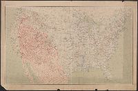
Description:
Ms. title "Limits of Arid Country" with arid area marked in red on map.
Publisher:
U.S. Geological Survey,
Subject (Geographic):
United States--Maps
Found in:
Beinecke Rare Book and Manuscript Library > United States, Contour Map.
Creator:
Published / Created:
1943
Call Number:
493 V24 1943
Container / Volume:
BRBL_00270
Image Count:
1
Resource Type:
Maps, Atlases & Globes
Alternative Title:
[Series] M991, Malta 1:7,500, Malta 1:7,500., and Valletta
Description:
"A.M.S. M991.", "Copied from British Admiralty H.O. chart no. 974.", "First edition 1943.", 3-43.", Relief shown by form lines., and Some streets and other features are named.
Publisher:
Army Map Service, U.S. Army,
Subject (Geographic):
Valletta (Malta)--Maps
Subject (Name):
Great Britain. Hydrographic Dept
Found in:
Beinecke Rare Book and Manuscript Library > Valletta city plan [cartographic material] / prepared under the direction of the Chief of Engineers, U.S. Army 1943.
Creator:
Published / Created:
1943
Call Number:
7391 1943
Container / Volume:
BRBL_00394
Image Count:
2
Resource Type:
Maps, Atlases & Globes
Alternative Title:
AMS ; A521 and Series (Standard map series designation system) ; A521.
Description:
Map originallly published by British Columbia Dept. of Lands., Northerly portion Vancouver Island, 1929, Map No. 2C -- Southerly portion Vancouver Island, 1938, Map No. 2A., Relief shown by s, and South sheet contains index map, location map, and mileage charts.
Publisher:
U.S. Army Map Service,
Subject (Geographic):
Vancouver Island (B.C.)--Maps
Subject (Name):
British Columbia. Dept. of Lands
Found in:
Beinecke Rare Book and Manuscript Library > Vancouver Island / Army Map Service.
Creator:
Published / Created:
1920
Call Number:
76gmb 1920A
Container / Volume:
BRBL_00446
Image Count:
2
Resource Type:
Maps, Atlases & Globes
Alternative Title:
Vermont New Hampshire
Description:
On verso: 13 ancillary maps of Vermont cities and towns, mileage tables, and hotel rates, advertising and illus.
Publisher:
The Association,
Subject (Geographic):
New Hampshire--Maps and Vermont--Maps
Found in:
Beinecke Rare Book and Manuscript Library > Vermont and New Hampshire / prepared by Touring Information Board American Automobile Association.
Creator:
Published / Created:
1943
Call Number:
40 V715 1943
Image Count:
1
Resource Type:
Maps, Atlases & Globes
Alternative Title:
Geographical Section, General Staff ; no. 4380, GSGS (Series) ; 4380., and Italy 1:4,000
Description:
"6-43.", "War Office 1943.", Military grid (blue)., and Some important buildings are named.
Publisher:
Army Map Service, U.S. Army,
Subject (Geographic):
Villa San Giovanni (Italy)--Maps
Subject (Name):
United States. Army Map Service
Found in:
Beinecke Rare Book and Manuscript Library > Villa San Giovanni [cartographic material] / compiled and drawn by Inter-Service Topographical Department ; produced under the Superintendence of Vice-Admiral John Edgell, hydrographer.
Branch:v1.65.8 ,Deployed:2025-04-02T07:25:24-04:00