Skip to search
Skip to main content
Skip to first result
Search
You Searched For
Genre
Maps
Subject (Name)
Andrew B. Graham Co
Publication Place
Washington, D.C. :
Search Results
Creator:
Published / Created:
c1897
Call Number:
848 1897E
Container / Volume:
BRBL_00630
Image Count:
1
Resource Type:
Maps, Atlases & Globes
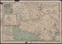
Description:
Includes ill., inset of "Klondike River and affluents," and distance table.
Publisher:
J.B. Tyrrell,
Subject (Geographic):
Copper River Region (Alaska)--Maps and Yukon Territory--Maps
Subject (Name):
Andrew B. Graham Co
Subject (Topic):
Copper River Region (Alaska)--Gold discoveries--Maps, Trails--Alaska--Copper River Region--Maps, Trails--Yukon Territory--Maps, and Yukon Territory--Gold discoveries--Maps
Found in:
Beinecke Rare Book and Manuscript Library > Gold region approaches by Copper River and the Dalton Trail / compiled from latest U.S. surveys, British authorities and other sources by J.B. Tyrrell.
Published / Created:
[1909?]
Call Number:
825 L487 1909A
Container / Volume:
BRBL_00574
Image Count:
1
Resource Type:
Maps, Atlases & Globes
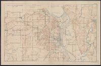
Description:
"Sgt. J. Howry, Draftsman."
Publisher:
A.B. Graham Co., Lithographers,
Subject (Geographic):
Fort Leavenworth (Kan.)--Maps
Subject (Name):
Andrew B. Graham Co and Howry, J
Found in:
Beinecke Rare Book and Manuscript Library > Map of Fort Leavenworth, Kansas and vicinity.
Creator:
Published / Created:
1905
Call Number:
899 1905
Container / Volume:
BRBL_00660
Image Count:
1
Resource Type:
Maps, Atlases & Globes
Description:
In lower left margin: Andrew B. Graham Co., lithographers, Washington, D.C.
Publisher:
National Geographic Society,
Subject (Geographic):
Canal Zone--Maps and Panama Canal (Panama)--Maps
Subject (Name):
Andrew B. Graham Co
Found in:
Beinecke Rare Book and Manuscript Library > Map showing location of Panama Canal : as recommended by the Isthmian Canal Commission of 1899-1902 / supplement to the National Geographic Magazine.
Creator:
Published / Created:
1907
Call Number:
832 1907
Container / Volume:
BRBL_00582
Image Count:
1
Resource Type:
Maps, Atlases & Globes
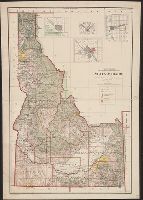
Abstract:
Shows township, railroad & county lines, forest, military & Indian reservations, etc.
Description:
Insets: Boise and vicinity -- Pocatello and vicinity -- Wallace and vicinity -- Lewiston and vicinity.
Publisher:
General Land Office,
Subject (Geographic):
Idaho--Maps
Subject (Name):
Andrew B. Graham Co, Bond, Frank, 1856-1940, and Helm, Charles J
Found in:
Beinecke Rare Book and Manuscript Library > State of Idaho : 1907 / compiled from the official records of the General Land Office and other sources under the direction of Frank Bond ; rev. & drawn by Charles J. Helm.