
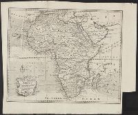
You Searched For
1 - 3 of 3
Search Results
2.
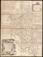
- Creator:
- Bowen, Emanuel, 1693 or 1694-1767
- Published / Created:
- [1785?]
- Call Number:
- BrSides Double Folio 2019 91
- Image Count:
- 1
- Resource Type:
- Maps, Atlases & Globes
- Description:
- Dedicated to Charles, Duke of Marlborough., Imperfect: trimmed along outside graticule, with some loss of text. Dissected and mounted on linen., Includes notes about the county and shows boundaries, roads, parks and settlements., Plate 6 from: The large English atlas, or, A new set of maps of all the counties in England and Wales / Emanuel Bowen. London: Printed and sold by Robert Wilkinson, at No. 58, in Cornhill, successor to Mr John Bowles, deceased, [1785]., Prime meridian: London., and Relief shown pictorially.
- Publisher:
- Printed for R. Sayer at the Golden Buck in Fleet Street, John Bowles at the Black Horse in Cornhil, and Carrington Bowles in St. Pauls Church Yard,
- Subject (Geographic):
- Buckinghamshire (England)--Maps--Early works to 1800.
- Subject (Name):
- Bowen, Emanuel, 1693 or 1694-1767. Large English atlas, or, A new set of maps of all the counties in England and Wales., Bowles, Carington, 1724-1793, Bowles, John, 1701-1779, and Sayer, Robert, 1725-1794
- Found in:
- Beinecke Rare Book and Manuscript Library > An accurate map of Buckingham Shire divided into its hundreds : drawn from the best authorities assisted by the most approved modern maps with various improvements. Illustrated with historical extracts relative to natural history, produce, trade and manufactures and the present state of the principal towns / by Eman. Bowen, Geogr. to His Majesty.
3.
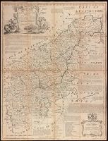
- Creator:
- Bowen, Emanuel, 1693 or 1694-1767
- Published / Created:
- [1785]
- Call Number:
- BrSides Double Folio 2019 90
- Image Count:
- 1
- Resource Type:
- Maps, Atlases & Globes
- Description:
- Dedication in decorative cartouche: To the Right Honble. George Montagu Earl of Halifax, Lord Lieutenant & Custos Rotulorum for the County of Northampton & First Commissioner of the Plantation Office. This map is humbly dedicated by His Lordship's obedt. servant Eman. Bowen., Dissected and mounted on linen., Includes text on some towns, their manufactures and natural products, Earls of Northampton, and seats of the Nobility., Plate 26 from: The large English atlas, or, A new set of maps of all the counties in England and Wales / Emanuel Bowen. London: Printed and sold by Robert Wilkinson, at No. 58, in Cornhill, successor to Mr John Bowles, deceased, [1785]., Prime meridian: London., and Relief shown pictorially.
- Publisher:
- Printed for Robt. Wilkinson, Cornhill & Robt. Sayer in Fleet Street, Carrington Bowles in St. Pauls Church Yard,
- Subject (Geographic):
- Northamptonshire (England)--Maps--Early works to 1800.
- Subject (Name):
- Bowen, Emanuel, 1693 or 1694-1767. Large English atlas, or, A new set of maps of all the counties in England and Wales., Bowles, Carington, 1724-1793, Sayer, Robert, 1725-1794, and Wilkinson, Robert, -approximately 1825
- Found in:
- Beinecke Rare Book and Manuscript Library > An accurate map of Northampton Shire divided into its hundreds : and laid down from the best authorities, assisted by the most approved modern maps, with various improvements, illustrated with historical extracts relative to its natural produce, trade, manufactures & present state of its principal towns / by Eman. Bowen Geogr. to His Majesty.