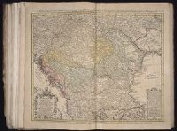
Dorn, Sebastian Hase, Johann Matthias, 1684-1742 Homann Erben (Firm)
Published / Created:
1744
Call Number:
1983 Folio 23
Collection Title:
[Atlas factice of 50 maps, primarily by Johann Baptist Homann and/or issued by the Homann Erben
Image Count:
1
Alternative Title:
Carte d’Hongrie en general, contenant selon la division ancienne & methodique, la Hongrie, en particulier, la Croatie, la Dalmatie, la Bosnie, la Servie, la Boulgarie, la Principaute de Transylvanie, les Despotats de Walachie & de Moldav and Hungariae ampliori significatu et veteris vel methodicae, complexae regna: Hungariae Propriae, Crotiae, Dalmatiae, Bosniae, Serviae, Cumaniae, principatum: Transylvaniae, despotus: Walachiae, Moldaviae (exclusis ab eadem alienatis Galitia et Ludmomiria) in suas provincias ac partes divisae et quoad Imperantes ex Austriacis, Turcis et Venetis distinctae (juncta tamen propter commidatem Romania vel Romelia Turcica) tabula
Publisher:
Curantibus Homannianis Heredibus
Subject (Geographic):
Balkan Peninsula --Maps --Early works to 1800 and Hungary --Maps --Early works to 1800
Dorn, Sebastian Hase, Johann Matthias, 1684-1742 Homann Erben (Firm)
Published / Created:
1744
Call Number:
1973 Folio 30
Collection Title:
[Atlas factice of 32 maps and 1 distance table, produced by the Homann Erben firm]
Image Count:
2
Alternative Title:
Carte d’Hongrie en general, contenant selon la division ancienne & methodique, la Hongrie, en particulier, la Croatie, la Dalmatie, la Bosnie, la Servie, la Boulgarie, la Principaute de Transylvanie, les Despotats de Walachie & de Moldav and Hungariae ampliori significatu et veteris vel methodicae, complexae regna: Hungariae Propriae, Crotiae, Dalmatiae, Bosniae, Serviae, Cumaniae, principatum: Transylvaniae, despotus: Walachiae, Moldaviae (exclusis ab eadem alienatis Galitia et Ludmomiria) in suas provincias ac partes divisae et quoad Imperantes ex Austriacis, Turcis et Venetis distinctae (juncta tamen propter commidatem Romania vel Romelia Turcica) tabula
Publisher:
Curantibus Homannianis Heredibus
Subject (Geographic):
Balkan Peninsula --Maps --Early works to 1800 and Hungary --Maps --Early works to 1800