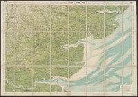
Bartholomew, J. G. (John George), 1860-1920 Edinburgh Geographical Institute
Published / Created:
[1900?]
Call Number:
3229 1900
Container / Volume:
BRBL_00063
Image Count:
1
Resource Type:
Maps, Atlases & Globes
Description:
"Roads revised by the Cyclists' Touring Club"--Bottom margin., "Sheet 12"--Top margin., Indicates first class, secondary and passable roads, footpaths & bridlepaths, hights in feet above sea level, railways and stations, canals, and county boundaries., and Relie
Publisher:
Edinburgh Geographical Institute,
Subject (Geographic):
Cheshire (England)--Maps
Subject (Topic):
Bicycle trails--England--Cheshire--Maps, Cycling--England--Cheshire--Maps, and Roads--England--Cheshire--Maps
Bartholomew, J. G. (John George), 1860-1920 Edinburgh Geographical Institute
Published / Created:
[1890?]
Call Number:
3258 1890
Container / Volume:
BRBL_00069
Image Count:
2
Resource Type:
Maps, Atlases & Globes
Alternative Title:
Hertforshire.
Description:
"Reduced by permission from the, Indicates first class, secondary and passable roads, footpaths & bridlepaths, hights in feet above sea level, railways and stations, canals, and county boundaries., and Relief shown by contours, gradient tints, and spot heights.
Publisher:
Edinburgh Geographical Institute,
Subject (Geographic):
Hertfordshire (England)--Maps
Subject (Topic):
Bicycle trails--England--Hertfordshire--Maps, Cycling--England--Hertfordshire--Maps, and Roads--England--Hertfordshire--Maps
Bartholomew, J. G. (John George), 1860-1920 Edinburgh Geographical Institute
Published / Created:
[19--?]
Call Number:
3225 1900
Container / Volume:
BRBL_00060
Image Count:
1
Resource Type:
Maps, Atlases & Globes
Description:
"Copyright, John Bartholomew., "Roads revised by the Cyclists' Touring Club"--Bottom margin., and Indicates first class, secondary and passable roads, footpaths & bridlepaths, hights in feet above sea level, railways and stations, canals, and county boundaries.
Publisher:
Edinburgh Geographical Institute,
Subject (Geographic):
Essex (England)--Maps and Essex (England)--Maps, Tourist
Subject (Topic):
Bicycle trails--England--Essex--Maps, Cycling--England--Essex--Maps, and Roads--England--Essex--Maps
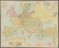
Edinburgh Geographical Institute John Bartholomew & Co
Published / Created:
[1914]
Call Number:
11hc 1914
Container / Volume:
BRBL_00010A
Image Count:
2
Resource Type:
Maps, Atlases & Globes
Description:
Includes 7 inset maps., Relief shown by spot heights., and Shows principal fortified towns, railways, main and other lines, shipping routes and distances.
Edinburgh Geographical Institute John Bartholomew & Co
Published / Created:
[1875?]
Call Number:
319 1875
Container / Volume:
BRBL_00040
Image Count:
1
Resource Type:
Maps, Atlases & Globes
Alternative Title:
Bartholomew's new reduced survey for tourists & cyclists.
Description:
Imperfect., Insets: Enlargement of South Lancashire & Yorkshire district -- London & suburbs -- Enlargement of Edinburgh and Glasgow district -- Birmingham -- Newcastle -- Swansea and Cardiff., and Relief shown by hachures and spot heights.