
You Searched For
1 entry found
Search Results
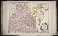
1. Carte de la Virginie et du Maryland
- Creator:
- Fry, Joshua, 1700 (ca.)-1754
Haussard, Elisabeth.
Jefferson, Peter, 1708-1757
Robert de Vaugondy, Gilles, 1688-1766
Robert de Vaugondy, Gilles, 1688-1766, creator - Published / Created:
- 1755
- Call Number:
- 2003 Folio 85
- Image Count:
- 1
- Description:
- BEIN 2003 Folio 85: No. 22 of 45 maps bound together with binder's spine title: Atlas of America; ms. table of contents. Bookplate: Robinson. Bookplate of Paul Mellon., dressee sur la grande carte angloise de Mrs. Josue Fry et Pierre Jefferson ; par le Sr. Robert de Vaugondy, geographe ordinaire du Roi., Grave E. Haussard., Hand colored., Relief shown pictorially., Scale [ca. 1:870,000], and Shows Virginia, Maryland, and De La War counties.
- Subject (Geographic):
- Maryland -- Maps -- 1755, Maryland -- Maps -- Early works to 1800, Middle Atlantic States -- Maps -- 1755, Middle Atlantic States -- Maps -- Early works to 1800, Virginia -- Maps -- 1755, and Virginia -- Maps -- Early works to 1800
- Found in:
- Beinecke Rare Book and Manuscript Library > Carte de la Virginie et du Maryland