Aeronautical and topographical map of United States. and Oklahoma
Description:
Includes inset of the panhandle, advertisement for "The Oklahoma Farmer-Stockman," and 9 photos., Index, population info., "Aeronautical and topographical map of United States," and text of U.S. air mail service on verso., and Relief shown by hachures.
Publisher:
George F. Cram,
Subject (Geographic):
Oklahoma--Maps
Subject (Topic):
Airways--United States--Maps and Roads--Oklahoma--Maps
"Prepared under the direction of the State Free Public Library Commission.", Printed on the Public Service Commission Map of the State of Vermont., and Relief shown by hachures.
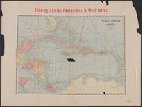
East Indies., Showing Spanish possessions in East Indies., and West Indies.
Description:
Also shows Central America and shipping routes., Alternate title: West Indies ; East Indies., Includes col. ill. of United States and Cuba flags., Map of West Indies includes inset., and Relief shown by hachures.
Publisher:
Geo. F. Cram, engraver and publisher,
Subject (Geographic):
Caribbean Area--Maps, East Indies--Maps, and West Indies--Maps
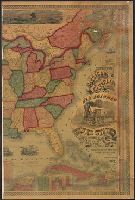
Across top of map: "Panoramic view of the country between San Francisco and St. Louis.", Includes ill., text, population information, and inset of "Central America.", Prime meridians: Washington and Greenwich., and Relief shown by hachures.