BEIN 2003 Folio 85: No. 7 of 45 maps bound together with binder's spine title: Atlas of America; ms. table of contents. Bookplate of Paul Mellon., Engraved by: Thomas Jefferys, geographer to his majesty., Hand-colored., Kershaw, Kenneth. Early printed maps of Canada, vol. 4, no. 1015., Map shows details of British and French positions during the siege of Quebec and table of references identifies British military units., Overlay provides details of changed position of British troops at the battle of September 13, 1759., Published in: A general topography of North America, London, 1768., and Scale 1:18,500.
Publisher:
Thos. Jefferys, the corner of St. Martins Lane Charing Cross
Subject (Geographic):
QueÌbec (QueÌbec) -- Maps -- Early works to 1800, QueÌbec Campaign, 1759 -- Maps, and United States -- History -- French and Indian War, 1755-1763 -- Maps
From Jefferys's The American atlas ... London : Printed and sold by R. Sayer and J. Bennett, 1776., Hand col. Sheet measures 55.1 x 73.5 cm. Stamped no. on verso: 12. Cross Collection no. 160., and Relief shown pictorially. Depths shown by soundings.
Publisher:
By Thomas Jefferys, geographer to the King, printed for Robt. Sayer & Jno. Bennett,
Subject (Geographic):
Newfoundland, Island of (N.L.)--Maps--Early works to 1800
Subject (Name):
Cook, James, 1728-1779, Jefferys, Thomas, d. 1771. American atlas, Lane, Michael, fl. 1768-1784, and Robert Sayer and John Bennett (Firm)
Includes historical notes, text, 3 distance charts, and inset of "A sketch of the remaining part of Ohio R. &c.", Prime meridians: Philadelphia and London., and Relief shown pictorially.
Publisher:
Sold by R. Sayer in Fleet Street & T. Jefferys, Charing Cross,
Subject (Geographic):
Northeastern States--Maps--Early works to 1800
Subject (Name):
Evans, Lewis, 1700?-1756 and Sayer, Robert, 1725-1794
Evans, Lewis, 1700?-1756 Gibson, J. (John), creator Jefferys, Thomas, d. 1771
Published / Created:
1758
Call Number:
2003 Folio 85
Image Count:
1
Alternative Title:
Middle British colonies
Description:
Available also through the Library of Congress Web site as a raster image., BEIN 2003 Folio 85: No. 17 of 45 maps bound together with binder's spine title: Atlas of America; ms. table of contents. Bookplate: Robinson. Bookplate of Paul Mellon., carefully copied from the original published at Philadelphia, by Mr. Lewis Evans 1755, with some improvements by I. Gibson., Hand colored., LC Maps of North America, 1750-1789,, Relief shown pictorially., Scale [ca. 1:2,250,000]., and Shows West longitude from London and from Philadelphia.
Publisher:
Sold by T. Jefferys
Subject (Geographic):
North America -- Maps -- Early works to 1800 and Northeastern States -- Maps -- Early works to 1800
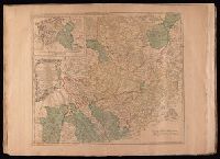
Electorate of Brunswick-Luneburg with its dependencies
Description:
Imperfect: torn along fold, with some loss of text. Sheet measures 75.0 x 62.4 cm. No. 30 of 34 maps bound together., Inset map: Plan of the battle of Minden on the 1st of August 1759., Prime meridian: Ferro., and Relief shown pictorially.
Bar scales given in "German miles 15 to a degree" and "English statute miles 69 & 1/2 to a degree"., Prime meridian: Ferro., Relief shown pictorially., Sheet measures 54.5 x 72.2 cm. No. 29 of 34 maps bound together., Title of inset map: East-Frieseland, lordship of Jever and the counties of Oldenburg and Delmenhorst., and Watermark.
Publisher:
Thomas Jefferys,
Subject (Geographic):
Lower Saxony (Germany)--Maps--Early works to 1800 and North Rhine-Westphalia (Germany)--Maps--Early works to 1800
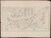
[Gulf of St. Laurence] -- The contents of the respective divisions of the island of St. John -- A list of lots and proprietors names., Depths shown by soundings., and Hand col. Sheet measures 55.2 x 73.8 cm. Cross Collection no. 172.
Publisher:
R. Sayer & J. Bennett?],
Subject (Geographic):
Prince Edward Island--Administrative and political divisions--Maps--Early works to 1800
Subject (Name):
Holland, Samuel, 1728-1801
Subject (Topic):
Real property--Prince Edward Island--Maps--Early works to 1800
Fry, Joshua, 1700 (ca.)-1754, creator Halifax, George Montagu-Dunk, Earl of, 1716-1771 Jefferson, Peter, 1708-1757 Jefferys, Thomas, d. 1771
Published / Created:
[1755]
Call Number:
2003 Folio 85
Image Count:
1
Description:
BEIN 2003 Folio 85: No. 21 of 45 maps bound together with binder's spine title: Atlas of America; ms. table of contents. Bookplate: Robinson. Bookplate of Paul Mellon., drawn by Joshua Fry & Peter Jefferson in 1751., Hand colored., Includes distance chart added by J. Dalrymple, London Jany. ye. 1st. 1755., Prime meridian: Philadelphia and Curratuck Inlet., Relief shown pictorially., Scale [ca. 1:650,000]., and To the Right Honourable, George Dunk Earl of Halifax ...
Publisher:
Thos. Jeffreys
Subject (Geographic):
Maryland -- Maps -- Early works to 1800, Middle Atlantic States -- Maps -- Early works to 1800, and Virginia -- Maps -- Early works to 1800