BEIN 2003 Folio 85: No. 7 of 45 maps bound together with binder's spine title: Atlas of America; ms. table of contents. Bookplate of Paul Mellon., Engraved by: Thomas Jefferys, geographer to his majesty., Hand-colored., Kershaw, Kenneth. Early printed maps of Canada, vol. 4, no. 1015., Map shows details of British and French positions during the siege of Quebec and table of references identifies British military units., Overlay provides details of changed position of British troops at the battle of September 13, 1759., Published in: A general topography of North America, London, 1768., and Scale 1:18,500.
Publisher:
Thos. Jefferys, the corner of St. Martins Lane Charing Cross
Subject (Geographic):
QueÌbec (QueÌbec) -- Maps -- Early works to 1800, QueÌbec Campaign, 1759 -- Maps, and United States -- History -- French and Indian War, 1755-1763 -- Maps
Evans, Lewis, 1700?-1756 Gibson, J. (John), creator Jefferys, Thomas, d. 1771
Published / Created:
1758
Call Number:
2003 Folio 85
Image Count:
1
Alternative Title:
Middle British colonies
Description:
Available also through the Library of Congress Web site as a raster image., BEIN 2003 Folio 85: No. 17 of 45 maps bound together with binder's spine title: Atlas of America; ms. table of contents. Bookplate: Robinson. Bookplate of Paul Mellon., carefully copied from the original published at Philadelphia, by Mr. Lewis Evans 1755, with some improvements by I. Gibson., Hand colored., LC Maps of North America, 1750-1789,, Relief shown pictorially., Scale [ca. 1:2,250,000]., and Shows West longitude from London and from Philadelphia.
Publisher:
Sold by T. Jefferys
Subject (Geographic):
North America -- Maps -- Early works to 1800 and Northeastern States -- Maps -- Early works to 1800
Electorate of Brunswick-Luneburg with its dependencies
Description:
Imperfect: torn along fold, with some loss of text. Sheet measures 75.0 x 62.4 cm. No. 30 of 34 maps bound together., Inset map: Plan of the battle of Minden on the 1st of August 1759., Prime meridian: Ferro., and Relief shown pictorially.
Fry, Joshua, 1700 (ca.)-1754, creator Halifax, George Montagu-Dunk, Earl of, 1716-1771 Jefferson, Peter, 1708-1757 Jefferys, Thomas, d. 1771
Published / Created:
[1755]
Call Number:
2003 Folio 85
Image Count:
1
Description:
BEIN 2003 Folio 85: No. 21 of 45 maps bound together with binder's spine title: Atlas of America; ms. table of contents. Bookplate: Robinson. Bookplate of Paul Mellon., drawn by Joshua Fry & Peter Jefferson in 1751., Hand colored., Includes distance chart added by J. Dalrymple, London Jany. ye. 1st. 1755., Prime meridian: Philadelphia and Curratuck Inlet., Relief shown pictorially., Scale [ca. 1:650,000]., and To the Right Honourable, George Dunk Earl of Halifax ...
Publisher:
Thos. Jeffreys
Subject (Geographic):
Maryland -- Maps -- Early works to 1800, Middle Atlantic States -- Maps -- Early works to 1800, and Virginia -- Maps -- Early works to 1800
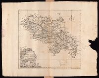
Hoüel, Jean-Pierre-Laurent, 1735-1813 Jefferys, Thomas, d. 1771
Published / Created:
[1768]
Call Number:
1977 Folio 177
Image Count:
2
Resource Type:
Maps, Atlases & Globes
Description:
Bar scales given in "British miles 69 to a degree" and "British and French sea leagues 20 to a degree"., Imperfect: torn and mutilated on the right side, with no loss of text. Sheet measures 44.5 x 56.5 cm. No. 13 of 34 maps bound together., Prime meridian: Ferro., Relief shown by hachures; depths by soundings., Shows habitation or plantations, sugar works, oxen and water mills, observations points, etc., and Watermark.
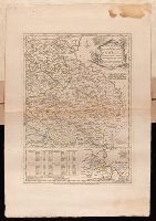
Plan of the country where the Prussian army gained a victory over the Austrians, Oct. 1, 1756. and Routes of the Prussian Armies into Bohemia
Description:
Bar scales given in "English miles 69 1/2 to a degree," "German miles 15 in a degree," and "Bohemian or gr ms. of Silesia 12 in a Deg.", Prime meridians: London and Ferro., Sheet measures 50.3 x 34.6 cm. No. 14 of 34 maps bound together., and With inset map: Plan of the country where the Prussian army gained a victory over the Austrians, Oct. 1, 1756.
Publisher:
T. Jeffreys,
Subject (Geographic):
Bohemia (Czech Republic)--Maps--Early works to 1800
Subject (Topic):
Seven Years' War, 1756-1763--Maps--Early works to 1800