Blaeu, Willem Janszoon, 1571-1638 Mercator, Gerhard, 1512-1594
Published / Created:
[ca. 1634]
Call Number:
1983 Folio 19
Collection Title:
[Atlas factice of 96 maps by Blaeu, Visscher, Jansson, Hondius and others]
Image Count:
1
Description:
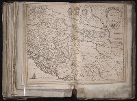
Imperfect: torn along fold, with some loss of text. Sheet measures 39 x 51.3 cm. Reinforced along edges with printed waste. No. 91 of 92 maps bound together. and Numbered 99 [98 and 100, cancelled] on verso.
Publisher:
Apud Guiljel. Blaeu
Subject (Geographic):
Bosnia and Hercegovina --Maps --Early works to 1800 and Croatia --Maps --Early works to 1800
Bar scale given in "milliaria Germanica" and "milliaria Italica"., From Willem and Joan Blaeu's Theatrum orbis terrarum. Amsterdami : Apud Guiljelmum et Iohannem Blaeu, 1635., and In Latin on verso; with caption title "Descriptio Sclavoniae, Croatiae, Bosniae,
Publisher:
Apud Guiljel. Blaeu,
Subject (Geographic):
Bosnia and Hercegovina--Maps--Early works to 1800 and Croatia--Maps--Early works to 1800
Subject (Name):
Blaeu, Joan, 1596-1673. Theatrum orbis terrarum and Blaeu, Willem Janszoon, 1571-1638. Theatrum orbis terrarum
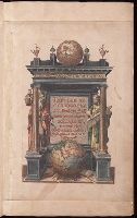
Signatures: [*]¹ (?)² (?)(?)¹ **² A-G² N² [+]¹ I-M² H² O-Z² Aa-Cc² a-g² h¹. Hand colored illustrations., Text on versos of most maps., and Title-page and maps hand-colored; inlaid.
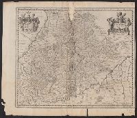
From Henricus Hondius and Joannes Janssonius's Atlas (English ed.), 1636., Imperfect: chipped and torn along fold, with some loss of text; trimmed, with some loss of text on verso. Sheet measures 42.3 x 49.2 cm., and In English on verso; with caption title "The
Publisher:
Excusum apud Henricum Hondium sub insigno Atlantis,
Subject (Geographic):
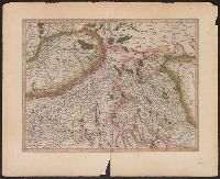
Württemberg (Germany)--Maps--Early works to 1800 and Württemberg-Baden (Germany)--Maps--Early works to 1800
Subject (Name):
Hondius, Hendrik, 1597-1651. Atlas novus. English and Jansson, Jan, 1588-1664. Atlas novus. English
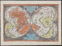
"Ne que ad nos Fram orbis ... Cappadocie 7.", "Quam hic vides orbis imagine lector cadide ... Vale 1538", Cordiform map of the world, 1538, Joanni Drosio suo Gerardus Rupelmudan deducabat., Map of the world, 1538, Orbis imago., and World map on double cordiform pro
Description:
Also known as World map on double cordiform projection and Orbis imago., Cross collection no. 4., Facsimile of Gerhard Mercator's first world map, published in Louvain, 1538., Relief shown pictorially., and Title from another facsimile published by the New York Public Library.
Publisher:
Julius Bien & Co., photo-lith,
Subject (Name):
Brevoort, James Carson, 1818-1887 and Julius Bien & Co
Subject (Topic):
Early maps--Facsimiles and World maps--Early works to 1800--Facsimiles
Appears in Mercator's Galliae tabula geographicae ... [Duisburg ca.1595]., Latin text on verso., Page number on verso "163-164"., Relief shown pictorially., Sheet measures 45.5 x 56.2 cm., and Title supplied by Koeman.
Publisher:
Gerardum Mercatorem,
Subject (Geographic):
Basel (Switzerland : Canton)--Maps--Early works to 1800, Switzerland--Maps--Early works to 1800, and Zurich (Switzerland : Canton)--Maps--Early works to 1800