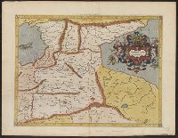
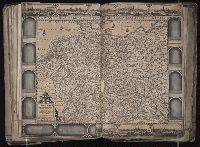
Mercator, Gerhard, 1512-1594 Ptolemy, active 2nd century
Published / Created:
1578
Call Number:
3546 1578
Container / Volume:
BRBL_00113
Image Count:
2
Resource Type:
Maps, Atlases & Globes
Alternative Title:
Tabulae geographicae.
Description:
From Tabulae geographicae Cl: Ptolemei ad mentem autoris restitutae & emendate per Gerardum Mercatorem ..., Latin text on verso., and Sheet measures 41.5 x 53 cm.
Publisher:
Typis Godefridi Kempensis, Anno Virgineit partus,
Subject (Geographic):
Armenia--Maps--Early works to 1800 and Asia--Maps--Early works to 1800
At head of title: Gerardi Mercatoris et I. Hondii., Engraved t.-p., and The paging is irregular, because many maps were inserted with the same page numbering as the preceding map.
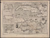
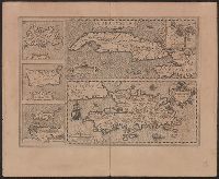
Blaeu, Willem Janszoon, 1571-1638 Mercator, Gerhard, 1512-1594
Published / Created:
[1647]
Call Number:
1983 Folio 19
Collection Title:
[Atlas factice of 96 maps by Blaeu, Visscher, Jansson, Hondius and others]
Image Count:
1
Description:
Imperfect: mutilated along fold, with some loss of text. Reinforced along edges with manuscript and printed waste. Sheet measures 39.1 x 50.8 cm. No. 77 of 92 maps bound together. and Numbered 83 on verso.
Ancillary maps: Insula Iamaica -- Ins. S. Ioannis -- Is. Margareta cum confinijis., Cuba Insula includes inset "Havana portus celeberimus totius indiae Occidentalis.", Latin text on verso; with caption title "Cuba, Hispaniola Iamai, and Relief shown pictorially.
Publisher:
Jodocus Hondius,
Subject (Geographic):
Cuba--Maps--Early works to 1800 and Hispaniola--Maps--Early works to 1800
Subject (Name):
Hondius, Jodocus, 1563-1612 and Mercator, Gerhard, 1512-1594. Atlas. French
Cuba Insula includes inset "Havana portus celeberimus totius indiae Occidentalis.", French text on verso; with caption title "Les isles de la Cuba, Espaignole, Iamaique, de S. Iean et Margarite," paginated 701, 704, with signatures 8P., and Relief shown pictorially.
Publisher:
Hendrik Hondius,
Subject (Geographic):
Cuba--Maps--Early works to 1800 and Hispaniola--Maps--Early works to 1800
Subject (Name):
Hondius, Hendrik, 1597-1651 and Mercator, Gerhard, 1512-1594. Atlas. French
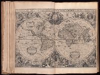
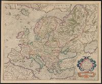
Mercator, Gerhard, 1512-1594 Mercator, Rumold, ca. 1545-1599
Published / Created:
[ca. 1595]
Call Number:
30 1595
Container / Volume:
BRBL_00029
Image Count:
2
Resource Type:
Maps, Atlases & Globes
Alternative Title:
Evropa
Description:
From: Atlas sive cosmogravicæ meditationes de fabrica mundi et fabricati figura / Gerardo Mercatore Rupelmundano ... autore. Atlantis pars altera: Geographia nova totius mundi (Duisburgi Clivorum : [s.n.] ; Dusseldorpii : excudebat Albertus Busius ..., su
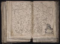
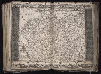
Mercator, Gerhard, 1512-1594 Visscher, Claes Jansz., 1586 or 7-1652
Published / Created:
ao. 1650
Call Number:
1983 Folio 19
Collection Title:
[Atlas factice of 96 maps by Blaeu, Visscher, Jansson, Hondius and others]
Image Count:
1
Description:
Imperfect: torn and mutilated along fold and edges, partially repaired, with some loss of text. Sheet measures 45.5 x 56.3 cm. No. 61 of 92 maps bound together. and Numbered 66 on verso.
Mercator, Gerhard, 1512-1594 Visscher, Claes Jansz., 1586 or 7-1652
Published / Created:
ao. 1657
Call Number:
1983 Folio 19
Collection Title:
[Atlas factice of 96 maps by Blaeu, Visscher, Jansson, Hondius and others]
Image Count:
1
Description:
Imperfect: torn and mutilated along fold and edges, partially repaired, with some loss of text. Sheet measures 45.0 x 56.0 cm. No. 62 of 92 maps bound together. and Numbered 67 on verso.