Imperfect: mutilated and torn along folds, with some loss of text. Cross collection no. 33.
Publisher:
Printed for and sold by I. Bowles, map and printseller at the Black Horse in Cornhill & by T. Bowles map & print seller next to ye Chapter house in St. Paul's Church yard, and by P. Overton map & print seller near St. Dunstan's Church Fleet Street and by
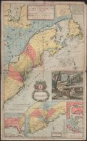
[South part of Carolina, and the east part of Florida], Draught of ye town and harbour of Charles-town, Map of the improved part of Carolina with the settlements, Map of the principal part of North America, and View of ye industry of ye beavers of Canada
Description:
Hand colored.
Publisher:
Printed and sold by Tho. Bowles ...,
Subject (Geographic):
France--Colonies--America--Maps--Early works to 1800, Great Britain--Colonies--America--Maps--Early works to 1800, North America--Maps--Early works to 1800, and United States--History--Colonial period, ca. 1600-1775--Maps--Ear
Inset illustration of the Reichstag of Holy Roman Empire, with title: The General Diet of the Empire, or it's Parliament.
Subject (Geographic):
Europe, Central--Maps--Early works to 1800, Germany--Maps--Early works to 1800, Hungary--Maps--Early works to 1800, Romania--Maps--Early works to 1800, and Switzerland--Maps--Early works to 1800
Subject (Name):
Holy Roman Empire.--Reichstag and Hughes, Thomas Lowe,--1925---Ownership
Harbour of Annapolis Royal, Indian fort Sasquesahanok, and Map of ye mouth of Mississipi and Mobile rivers &c
Description:
Appears in Moll's The world described.
Publisher:
Sold by H. Moll over against Devereus Court between Temple Bar and St. Clements Church in the Strand ... [and] sold by Tho: Bowles ... Iohn King ... Iohn Bowles,
Subject (Geographic):
North America--Maps--Early works to 1800
Subject (Name):
Bowles, John, 1701-1779, bookseller, Bowles, Thomas, -1767, bookseller, and Moll, Herman, -1732. World described
BEIN 1976 1233: Imperfect: map "New Guinea, &c." [no. 2 of America] wanting. Map "Virginia and Maryland" [no. 19] bound following "Carolina and Bermudos" [no. 20]. Additional map, "Asiae antiquis simae ... ex aevi antiqui tenebris eruit Wilhelmus Stuk...