"The index letters and figures on margin of this map correspond with ... Rand McNally & Co.'s Complete City Railway and Street Number Guide to Chicago.", Includes explanation of street numbering system as of September 1, 1909., and Indexed to railroads.
Publisher:
Rand McNally & Co.,
Subject (Geographic):
Chicago (Ill.)--Maps
Subject (Topic):
Railroads--Illinois--Chicago--Maps and Street-railroads--Illinois--Chicago--Maps
Rand McNally stratoview map of eastern Asia from the Philippine Sea. and Reference map of the Pacific Ocean with 29 large-scale insets of island groups.
Description:
On verso, [ca. 1:13,125,000]: Rand McNally stratoview map of eastern Asia from the Philippine Sea.
Publisher:
Rand McNally & Co.,
Subject (Geographic):
East Asia--Maps, Islands of the Pacific--Maps, and Pacific Ocean--Maps
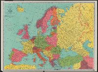
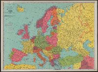
On verso: Europe in 1921, with railways. - Western fron. - Section of Maginot line fortification. - Europe air mileage distances. - Unification of Germany, 1866-1871. - Text., Shows 1914 boundarie, and Title on cover when folded: Rand McNally war map of Europe.
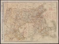
Includes index to counties and principal cities, list of Massachusetts railroads, and steamship routes., Inset: "Environs of Boston.", Relief shown by hachures and spot height, and Verso: Rand McNally Main Highway map of Massachusetts overlaid on map from recto.
Publisher:
Rand McNally & Co.,
Subject (Geographic):
Massachusetts--Maps
Subject (Topic):
Railroads--Massachusetts--Maps and Roads--Massachusetts--Maps
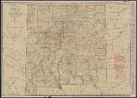
Rand McNally standard map of Montana. and Standard map of Montana with air trails.
Description:
In lower right of air trails map: 12N28, 7R28., Indexed., Relief shown by hachures and spot heights., and Verso: Rand McNally standard map of Montana [without air trails] partially obscured by linen backing.
Rand McNally standard map of New Mexico with air trails., Standard map of New Mexico, and Standard map of New Mexico with air trails.
Description:
"12N28" and "7R28.", Air trails map designed to be used with an "index booklet"; library's copy without booklet., Indexed., Relief shown by hachures and spot heights., and Shows railroads and counties.
Publisher:
Rand McNally & Co.,
Subject (Geographic):
New Mexico--Administrative and political divisions--Maps and New Mexico--Maps
Subject (Topic):
Airways--New Mexico--Maps and Railroads--New Mexico--Maps
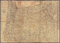
Rand McNally standard map of North Dakota. and Standard map of North Dakota with air trails.
Description:
Imperfect : Mounted on linen so standard map on verso [without air trails] is not directly visible., In lower right of air trails map: 12N28, 7R28., Indexed., and Relief shown by hachures and spot heights.