
You Searched For
Search Results

64. Farmington, Hartford County, Connecticut.
- Creator:
- Sanborn Map Company, issuing body
- Published / Created:
- 1924
- Call Number:
- 766 F22 1924
- Image Count:
- 4
- Resource Type:
- Maps, Atlases & Globes
- Abstract:
- Sanborn fire insurance maps are a rich source of historic data on the urban built environment of North America during the 19th and early 20th centuries. The atlases were created for the purpose of underwriting fire insurance policies, which depended upon accurate and frequently-updated information about construction materials, municipal and transportation infrastructure, industrial and commercial landuse and more. The Yale University Library Map Department scanned its holdings of Sanborn fire insurance maps (consisting primarily of Connecticut towns) in order to make the maps more accessible.
- Alternative Title:
- Sept. 1924, Farmington, Conn.
- Description:
- "(1824). (4 sheets).", Contains information on population, prevailing winds, water facilities and fire department., Includes index of specials., Partial cadastral map., and SMLMAPL 766 F22 1924: Sheets disbound. Library of Congress copyright stamp on title sheet.
- Subject (Geographic):
- Farmington (Conn. : Town)--Maps
- Subject (Name):
- Library of Congress Stamp
- Subject (Topic):
- Fire risk assessment--Connecticut--Farmington (Town)--Maps and Real property--Connecticut--Farmington (Town)--Maps
- Found in:
- Beinecke Rare Book and Manuscript Library > Farmington, Hartford County, Connecticut.

65. Glastonbury, Hartford County, Connecticut.
- Creator:
- Sanborn Map Company, issuing body
- Published / Created:
- 1928
- Call Number:
- 766 G46 1928
- Image Count:
- 8
- Resource Type:
- Maps, Atlases & Globes
- Abstract:
- Sanborn fire insurance maps are a rich source of historic data on the urban built environment of North America during the 19th and early 20th centuries. The atlases were created for the purpose of underwriting fire insurance policies, which depended upon accurate and frequently-updated information about construction materials, municipal and transportation infrastructure, industrial and commercial landuse and more. The Yale University Library Map Department scanned its holdings of Sanborn fire insurance maps (consisting primarily of Connecticut towns) in order to make the maps more accessible.
- Alternative Title:
- Jan. 1928, Glastonbury, Conn.
- Description:
- "(3445) (8 sheets).", Contains information on population, prevailing winds, water facilities and fire department., Includes index of streets and specials., Partial cadastral map., Sheets 5-8 at scale 1:600; Sheets 1-4 at scale 1:1,200., and SMLMAPL 766 G46 1928: Sheets disbound. Library of Congress copyright stamp on title sheet.
- Subject (Geographic):
- Glastonbury (Conn.)--Maps
- Subject (Name):
- Library of Congress Stamp
- Subject (Topic):
- Fire risk assessment--Connecticut--Glastonbury--Maps and Real property--Connecticut--Glastonbury--Maps
- Found in:
- Beinecke Rare Book and Manuscript Library > Glastonbury, Hartford County, Connecticut.
66. Guilford, New Haven Co., Conn.
- Creator:
- Sanborn Map Company, issuing body
- Published / Created:
- 1925
- Call Number:
- 766 G94 1925
- Image Count:
- 7
- Resource Type:
- Maps, Atlases & Globes
- Abstract:
- Sanborn fire insurance maps are a rich source of historic data on the urban built environment of North America during the 19th and early 20th centuries. The atlases were created for the purpose of underwriting fire insurance policies, which depended upon accurate and frequently-updated information about construction materials, municipal and transportation infrastructure, industrial and commercial landuse and more. The Yale University Library Map Department scanned its holdings of Sanborn fire insurance maps (consisting primarily of Connecticut towns) in order to make the maps more accessible.
- Alternative Title:
- Apr. 1925, Guilford, Conn.
- Description:
- "(2123). (7 sheets).", Contains information on population, prevailing winds, water facilities and fire department., Includes index of streets and specials., Partial cadastral map., Sheets 2-3 at scale 1:600 ; Sheets 1, 4-7 at scale 1:1,200., and SMLMAPL 766 G94 1925: Sheets disbound. Library of Congress copyright stamp on title sheet.
- Subject (Geographic):
- Guilford (Conn.)--Maps
- Subject (Name):
- Library of Congress--Stamp
- Subject (Topic):
- Fire risk assessment--Connecticut--Guilford--Maps and Real property--Connecticut--Guilford--Maps
- Found in:
- Beinecke Rare Book and Manuscript Library > Guilford, New Haven Co., Conn.
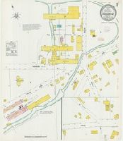
67. Higganum, Middlesex Co., Conn.
- Creator:
- Sanborn Map Company, issuing body
- Published / Created:
- 1908
- Call Number:
- 766 H53 1908
- Image Count:
- 2
- Resource Type:
- Maps, Atlases & Globes
- Abstract:
- Sanborn fire insurance maps are a rich source of historic data on the urban built environment of North America during the 19th and early 20th centuries. The atlases were created for the purpose of underwriting fire insurance policies, which depended upon accurate and frequently-updated information about construction materials, municipal and transportation infrastructure, industrial and commercial landuse and more. The Yale University Library Map Department scanned its holdings of Sanborn fire insurance maps (consisting primarily of Connecticut towns) in order to make the maps more accessible.
- Alternative Title:
- Mar. 1908, Higganum, Conn.
- Description:
- "2 sheets. 162.", "Town of Haddam.", Contains information on population, prevailing winds, water facilities and fire department., Partial cadastral map., and SMLMAPL 766 H53 1908: Sheets disbound. "Triplicate" stamp on both sheets. Library of Congress copyright and Map Division stamps on title sheet.
- Subject (Geographic):
- Higganum (Conn.)--Maps
- Subject (Name):
- Library of Congress Stamp and Library of Congress. Map Division Stamp
- Subject (Topic):
- Fire risk assessment--Connecticut--Higganum--Maps and Real property--Connecticut--Higganum--Maps
- Found in:
- Beinecke Rare Book and Manuscript Library > Higganum, Middlesex Co., Conn.
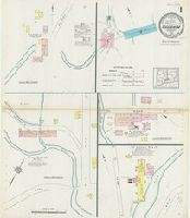
68. Higganum, Middlesex County, Connecticut.
- Creator:
- Sanborn Map Company, issuing body
- Published / Created:
- 1914
- Call Number:
- 766 H53 1914
- Image Count:
- 3
- Resource Type:
- Maps, Atlases & Globes
- Abstract:
- Sanborn fire insurance maps are a rich source of historic data on the urban built environment of North America during the 19th and early 20th centuries. The atlases were created for the purpose of underwriting fire insurance policies, which depended upon accurate and frequently-updated information about construction materials, municipal and transportation infrastructure, industrial and commercial landuse and more. The Yale University Library Map Department scanned its holdings of Sanborn fire insurance maps (consisting primarily of Connecticut towns) in order to make the maps more accessible.
- Alternative Title:
- Mar. 1914, Higganum, Conn.
- Description:
- "6712 (3 sheets).", "Town of Haddam.", Contains information on population, prevailing winds, water facilities and fire department., Includes index of specials., Partial cadastral map., and SMLMAPL 766 H53 1914: Sheets disbound. Library of Congress copyright stamp on title sheet.
- Subject (Geographic):
- Higganum (Conn.)--Maps
- Subject (Name):
- Library of Congress Stamp
- Subject (Topic):
- Fire risk assessment--Connecticut--Higganum--Maps and Real property--Connecticut--Higganum--Maps
- Found in:
- Beinecke Rare Book and Manuscript Library > Higganum, Middlesex County, Connecticut.

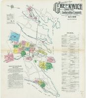
69. Insurance Maps of Greenwich, Connecticut.
- Creator:
- Sanborn Map Company, issuing body
- Published / Created:
- 1920
- Call Number:
- 766 G852 1920
- Image Count:
- 74
- Resource Type:
- Maps, Atlases & Globes
- Abstract:
- Sanborn fire insurance maps are a rich source of historic data on the urban built environment of North America during the 19th and early 20th centuries. The atlases were created for the purpose of underwriting fire insurance policies, which depended upon accurate and frequently-updated information about construction materials, municipal and transportation infrastructure, industrial and commercial landuse and more. The Yale University Library Map Department scanned its holdings of Sanborn fire insurance maps (consisting primarily of Connecticut towns) in order to make the maps more accessible.
- Alternative Title:
- Greenwich, Conn. and Greenwich, Connecticut
- Description:
- (3123). 69 sheets., Contains information on population, prevailing winds, water facilities and fire department., Includes index of streets, specials, and estates and villas., Partial cadastral map., Sheets 1-3, 5-6, and 13 at scale 1:600; Sheets 4, 7-12, 14-24, 34-35, 37-40, 42, 47-50, 52, and 60-68 at scale 1:1,200; Sheets 25-28, 51, and 53-56 at scale 1:1,800; Sheets 31-33, 36, 41, 43-46, 59, and 69 at scale 1:2,400; Sheets 29-30 and 57-58 at scale 1:3,000., SMLMAPL 766 G852 1920: Sheets disbound. Library of Congress copyright manuscript note on title sheet., and The unnumbered leaves are the title sheet, 2 index sheets, and 2 map index sheets.
- Subject (Geographic):
- Greenwich (Conn. : Town)--Maps
- Subject (Name):
- Library of Congress--Ownership
- Subject (Topic):
- Fire risk assessment--Connecticut--Greenwich (Town)--Maps and Real property--Connecticut--Greenwich (Town)--Maps
- Found in:
- Beinecke Rare Book and Manuscript Library > Insurance Maps of Greenwich, Connecticut.
70. Insurance Maps of Greenwich, Fairfield Co., Connecticut.
- Creator:
- Sanborn Map Company, issuing body
- Published / Created:
- 1912
- Call Number:
- 766 G852 1912
- Image Count:
- 25
- Resource Type:
- Maps, Atlases & Globes
- Abstract:
- Sanborn fire insurance maps are a rich source of historic data on the urban built environment of North America during the 19th and early 20th centuries. The atlases were created for the purpose of underwriting fire insurance policies, which depended upon accurate and frequently-updated information about construction materials, municipal and transportation infrastructure, industrial and commercial landuse and more. The Yale University Library Map Department scanned its holdings of Sanborn fire insurance maps (consisting primarily of Connecticut towns) in order to make the maps more accessible.
- Alternative Title:
- Greenwich, Fairfield Co., Connecticut and May 1912, Greenwich, Conn.
- Description:
- "25 sheets. (4872).", Contains information on population, prevailing winds, water facilities and fire department., Includes index of streets and specials., Partial cadastral map., Sheets 1-19 and 25 at scale 1:600; Sheets 20-24 at scale 1:1,200., and SMLMAPL 766 G852 1912: Sheets disbound. "Triplicate" stamp on all sheets. Library of Congress copyright stamp on title sheet.
- Subject (Geographic):
- Greenwich (Conn. : Town)--Maps
- Subject (Name):
- Library of Congress--Stamp
- Subject (Topic):
- Fire risk assessment--Connecticut--Greenwich (Town)--Maps and Real property--Connecticut--Greenwich (Town)--Maps
- Found in:
- Beinecke Rare Book and Manuscript Library > Insurance Maps of Greenwich, Fairfield Co., Connecticut.

71. Insurance Maps of Greenwich, Fairfield County, Connecticut.
- Creator:
- Sanborn Map Company, issuing body
- Published / Created:
- 1906
- Call Number:
- 766 G852 1906
- Image Count:
- 18
- Resource Type:
- Maps, Atlases & Globes
- Abstract:
- Sanborn fire insurance maps are a rich source of historic data on the urban built environment of North America during the 19th and early 20th centuries. The atlases were created for the purpose of underwriting fire insurance policies, which depended upon accurate and frequently-updated information about construction materials, municipal and transportation infrastructure, industrial and commercial landuse and more. The Yale University Library Map Department scanned its holdings of Sanborn fire insurance maps (consisting primarily of Connecticut towns) in order to make the maps more accessible.
- Alternative Title:
- Greenwich, Fairfield County, Connecticut and Sep. 1906, Greenwich, Conn.
- Description:
- "18 sheets. (8994).", Contains information on population, prevailing winds, water facilities and fire department., Includes index of streets and specials., Partial cadastral map., Sheets 1-13 at scale 1:600; Sheets 14-18 at scale 1:1,200., and SMLMAPL 766 G852 1906: Sheets disbound. "Triplicate" stamp on all sheets. Library of Congress copyright stamp on title sheet.
- Subject (Geographic):
- Greenwich (Conn. : Town)--Maps
- Subject (Name):
- Library of Congress--Stamp
- Subject (Topic):
- Fire risk assessment--Connecticut--Greenwich (Town)--Maps and Real property--Connecticut--Greenwich (Town)--Maps
- Found in:
- Beinecke Rare Book and Manuscript Library > Insurance Maps of Greenwich, Fairfield County, Connecticut.
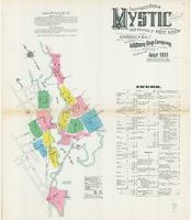
72. Insurance Maps of Mystic, including Old Mystic and West Mystic, New London County, Connecticut.
- Creator:
- Sanborn Map Company, issuing body
- Published / Created:
- 1911
- Call Number:
- 766 M992 1911
- Image Count:
- 13
- Resource Type:
- Maps, Atlases & Globes
- Abstract:
- Sanborn fire insurance maps are a rich source of historic data on the urban built environment of North America during the 19th and early 20th centuries. The atlases were created for the purpose of underwriting fire insurance policies, which depended upon accurate and frequently-updated information about construction materials, municipal and transportation infrastructure, industrial and commercial landuse and more. The Yale University Library Map Department scanned its holdings of Sanborn fire insurance maps (consisting primarily of Connecticut towns) in order to make the maps more accessible.
- Alternative Title:
- July 1911, Mystic, Conn. and Mystic, including Old Mystic and West Mystic, New London County, Connecticut
- Description:
- "3838 (13 sheets).", Contains information on population, prevailing winds, water facilities and fire department., Includes index of streets and specials., Partial cadastral map., and SMLMAPL 766 M992 1911: Sheets disbound. Library of Congress copyright stamp on title sheet.
- Subject (Geographic):
- Mystic (Conn.)--Maps
- Subject (Name):
- Library of Congress Stamp
- Subject (Topic):
- Fire risk assessment--Connecticut--Mystic--Maps and Real property--Connecticut--Mystic--Maps
- Found in:
- Beinecke Rare Book and Manuscript Library > Insurance Maps of Mystic, including Old Mystic and West Mystic, New London County, Connecticut.