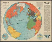
"A Fortune map.", "Centered at 35⁰N 30⁰W.", "Orthographic projection.", "Supplement to Fortune, June, 1942.", and Includes text, diagrams, and map of "The other half."
Publisher:
Time,
Subject (Geographic):
Atlantic Ocean--Maps
Subject (Topic):
World War, 1939-1945--Campaigns--Atlantic Ocean--Maps
"Enlargement of original map drawn for TIME.", "For report documenting above map see TIME, January 1, 1945 issue.", and Shows U.S. counterattacks on Germans during Battle of the Bulge.
Publisher:
: TIME, Inc.,
Subject (Geographic):
Rhine River Valley--Maps
Subject (Topic):
Ardennes, Battle of the, 1944-1945--Maps and World War, 1939-1945--Campaigns--Western Front--Maps
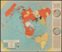
"A Fortune map.", "North polar azimuthal equidistant projection.", "Supplement to Fortune, March, 1942.", and Includes text and maps of "The Atlantic bridge" and "The Pacific vastness."
"Enlargement of original map drawn for TIME.", "For report documenting above map see TIME, December 4, 1944 issue.", and Map anticipates imminent defeat of Germany, showing likely Allied invasion routes.
Publisher:
: TIME, Inc.,
Subject (Geographic):
Germany--Maps
Subject (Topic):
World War, 1939-1945--Campaigns--Western Front--Maps and World War, 1939-1945--Germany--Maps