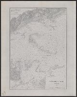
1. Cape Orford and reef, Oregon / U.S. Coast Survey, Benjamin Peirce, superintendant ; triangulation Creator: Peirce, Benjamin, 1809-1880United States Coast Survey Published / Created: 1869 Call Number: 846cea Or4 1869 Container / Volume: BRBL_00623 Image Count: 1 Resource Type: Maps, Atlases & Globes Description: In upper left margin: No. 16. Publisher: U.S. Coast Survey, Subject (Geographic): Blanco, Cape (Or.)--Maps and Port Orford (Or.)--Maps Subject (Name): United States Coast Survey. Annual report of the superintendent of the Coast Survey. 1869 Subject (Topic): Nautical charts--Oregon--Blanco, Cape Found in: Beinecke Rare Book and Manuscript Library > Cape Orford and reef, Oregon / U.S. Coast Survey, Benjamin Peirce, superintendant ; triangulation by A.W. Chase, sub-assistant in 1869 ; topography by A.M. Harrison, assist. and A.W. Chase, sub-assistant in 1851 & '69 ; hydrography by Commander J. Alden U
2. Entrance to Nantucket Sound / United States Coast Survey. Creator: United States Coast Survey Published / Created: 1883 Call Number: 7645cea 1883 Container / Volume: BRBL_00463 Image Count: 1 Resource Type: Maps, Atlases & Globes Description: "Plate no. 1442." Publisher: United States Coast Survey] Subject (Geographic): Nantucket Sound (Mass.)--Maps Subject (Topic): Nautical charts--Massachusetts--Nantucket Sound Found in: Beinecke Rare Book and Manuscript Library > Entrance to Nantucket Sound / United States Coast Survey.
3. Gulf of Maine, current stations / United States Coast Survey. Creator: United States Coast Survey Published / Created: 1883 Call Number: 761CEB 1883 Container / Volume: BRBL_00449 Image Count: 1 Resource Type: Maps, Atlases & Globes Description: "Plate No. 1446." Publisher: The Survey, Subject (Geographic): Maine, Gulf of--Maps and North Atlantic Ocean--Maps Subject (Topic): Nautical charts--Maine, Gulf of and Nautical charts--North Atlantic Ocean Found in: Beinecke Rare Book and Manuscript Library > Gulf of Maine, current stations / United States Coast Survey.
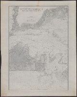
4. Nantucket Sound Western Part / United States Coast Survey. Creator: United States Coast Survey Published / Created: 1883 Call Number: 7645cea 1883A Container / Volume: BRBL_00463 Image Count: 1 Resource Type: Maps, Atlases & Globes Description: "Plate no. 1383." Publisher: United States Coast Survey] Subject (Geographic): Nantucket Sound (Mass.)--Maps Subject (Topic): Nautical charts--Massachusetts--Nantucket Sound Found in: Beinecke Rare Book and Manuscript Library > Nantucket Sound Western Part / United States Coast Survey.
5. Nantucket and Vineyard Sounds : from Cross Rip to Nobska Point / United States Coast Survey. Creator: United States Coast Survey Published / Created: 1883 Call Number: 7645cea 1883B Container / Volume: BRBL_00463 Image Count: 1 Resource Type: Maps, Atlases & Globes Description: "Plate no. 1559." Publisher: United States Coast Survey] Subject (Geographic): Nantucket Sound (Mass.)--Maps Subject (Topic): Nautical charts--Massachusetts--Nantucket Sound Found in: Beinecke Rare Book and Manuscript Library > Nantucket and Vineyard Sounds : from Cross Rip to Nobska Point / United States Coast Survey.