Search
You Searched For
Search Results
- Creator:
- U.S. Coast and Geodetic Survey
United States. Army Map Service
- Published / Created:
- 1944
- Call Number:
- 28 T11 1944
- Container / Volume:
- BRBL_00024
- Image Count:
- 1
- Resource Type:
- Maps, Atlases & Globes
- Alternative Title:
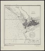
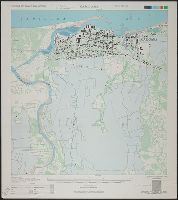
- A.M.S. ; S901, Series (Standard map series designation system) ; S901., and Taal and Lemery, Philippine Islands, Batangas Province
- Description:
- "Copied from U.S.C. & G.S. chart 4257 ... From survey in 1905." and "Soundings in feet at mean lower low water."
- Publisher:
- The Service,
- Subject (Geographic):
- Lemery (Batangas, Philippines)--Maps and Taal (Batangas, Philippines)--Maps
- Found in:
- Beinecke Rare Book and Manuscript Library > Philippine Islands city plans. Taal and Lemery.
- Creator:
- United States. Army Map Service
- Published / Created:
- 1944
- Call Number:
- 28 T175 1944
- Container / Volume:
- BRBL_00024
- Image Count:
- 1
- Resource Type:
- Maps, Atlases & Globes
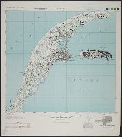
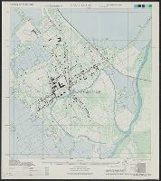
- Alternative Title:
- A.M.S. ; S901, Series (Standard map series designation system) ; S901., and Tarlac, Philippine Islands, Tarlac Province
- Publisher:
- The Service,
- Subject (Geographic):
- Tarlac (Philippines)--Maps
- Found in:
- Beinecke Rare Book and Manuscript Library > Philippine Islands city plans. Tarlac.
- Creator:
- United States. Army Map Service
- Published / Created:
- 1944
- Call Number:
- 28 C316 1944
- Container / Volume:
- BRBL_00023F
- Image Count:
- 1
- Resource Type:
- Maps, Atlases & Globes
- Alternative Title:
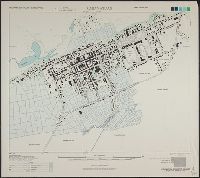
- A.M.S. ; S901, Cavite, Philippine Islands, Cavite Province, Luzon, and Series (Standard map series designation system) ; S901.
- Description:
- Marginal map: Coverage diagram. and Military grid.
- Publisher:
- The Service,
- Subject (Geographic):
- Cavite Province (Philippines)--Maps
- Found in:
- Beinecke Rare Book and Manuscript Library > Philippine city plans, 1:10,000. Cavite.
- Creator:
- United States. Army Map Service
- Published / Created:
- 1944
- Call Number:
- 28 C111 1944
- Container / Volume:
- BRBL_00023F
- Image Count:
- 1
- Resource Type:
- Maps, Atlases & Globes
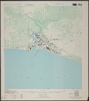
- Alternative Title:
- A.M.S. ; S901, Cabanatuan, Philippine Islands, Nueva Ecija Province, Luzon, and Series (Standard map series designation system) ; S901.
- Description:
- "Coverage diagram" in margin. and Some streets are named and areas of cultivation are shown.
- Publisher:
- The Service,
- Subject (Geographic):
- Cabanatuan (Philippines)--Maps
- Found in:
- Beinecke Rare Book and Manuscript Library > Philippine city plans, 1:5,000 (approx.) Cabanatuan.
- Creator:
- United States. Army Map Service
- Published / Created:
- 1944
- Call Number:
- 28 C126 1944
- Container / Volume:
- BRBL_00023F
- Image Count:
- 1
- Resource Type:
- Maps, Atlases & Globes
- Alternative Title:
- A.M.S. ; S901, Calbayog, Philippine Islands, Samar Province, Samar, and Series (Standard map series designation system) ; S901.
- Description:
- Marginal map: Coverage diagram. and Some streets are named.
- Publisher:
- The Service,
- Subject (Geographic):
- Calbayog (Philippines)--Maps
- Found in:
- Beinecke Rare Book and Manuscript Library > Philippine city plans, 1:5,000 (approx.) Calbayog.
- Creator:
- United States. Army Map Service
- Published / Created:
- 1944
- Call Number:
- 28 C19 1944
- Container / Volume:
- BRBL_00023F
- Image Count:
- 1
- Resource Type:
- Maps, Atlases & Globes
- Alternative Title:
- A.M.S. ; S901, Carigara, Philippine Islands, Leyte Province, Leyte, and Series (Standard map series designation system) ; S901.
- Description:
- Areas of vegetation and cultivation are shown. and Marginal diagram: Coverage diagram.
- Publisher:
- The Service,
- Subject (Geographic):
- Carigara (Leyte, Philippines)--Maps
- Found in:
- Beinecke Rare Book and Manuscript Library > Philippine city plans, 1:5,000 (approx.) Carigara.
- Creator:
- United States. Army Map Service
- Published / Created:
- 1944
- Call Number:
- 28 P186 1944
- Container / Volume:
- BRBL_00024
- Image Count:
- 1
- Resource Type:
- Maps, Atlases & Globes
- Alternative Title:
- A.M.S. ; S901, Palo, Philippine Islands, Leyte Province, Leyte, and Series (Standard map series designation system) ; S901.
- Description:
- Marginal diagram: Coverage diagram., Military grid., and Wooded areas are shown.
- Publisher:
- The Service,
- Subject (Geographic):
- Palo (Leyte, Philippines)--Maps
- Found in:
- Beinecke Rare Book and Manuscript Library > Philippine city plans, 1:5,000 (approx.) Palo.
- Creator:
- United States. Army Map Service
- Published / Created:
- 1944
- Call Number:
- 28 SA53 1944
- Container / Volume:
- BRBL_00024
- Image Count:
- 1
- Resource Type:
- Maps, Atlases & Globes
- Alternative Title:
- A.M.S. ; S901, San Pablo, Philippine Islands, Laguna Province, Luzon, and Series (Standard map series designation system) ; S901.
- Description:
- Marginal map: Coverage diagram. and Most streets are named and areas of vegetation are shown.
- Publisher:
- The Service,
- Subject (Geographic):
- San Pablo (Philippines)--Maps
- Found in:
- Beinecke Rare Book and Manuscript Library > Philippine city plans, 1:5,000 (approx.) San Pablo.
- Creator:
- United States. Army Map Service
- Published / Created:
- 1944
- Call Number:
- 28 C281 1944
- Container / Volume:
- BRBL_00023F
- Image Count:
- 1
- Resource Type:
- Maps, Atlases & Globes
- Alternative Title:
- A.M.S. ; S901, Catbalogan, Philippine Islands, Samar Province, Samar, and Series (Standard map series designation system) ; S901.
- Description:
- Marginal map: Coverage diagram. and Some streets and buildings are named.
- Publisher:
- The Service,
- Subject (Geographic):
- Catbalogan (Philippines)--Maps
- Found in:
- Beinecke Rare Book and Manuscript Library > Philippine city plans, 1:5,000. Catbalogan.
- Creator:
- United States. Army Map Service
- Published / Created:
- 1944
- Call Number:
- 28 SA51 1944
- Container / Volume:
- BRBL_00024
- Image Count:
- 1
- Resource Type:
- Maps, Atlases & Globes
- Alternative Title:
- A.M.S. ; S901, San Carlos, Philippine Islands, Pangasinan Province, Luzon, and Series (Standard map series designation system) ; S901.
- Description:
- Areas of vegetation and cultivation are shown., Marginal diagram: Coverage diagram., and Military grid.
- Publisher:
- The Service,
- Subject (Geographic):
- San Carlos (Pangasinan, Philippines)--Maps
- Found in:
- Beinecke Rare Book and Manuscript Library > Philippine city plans, 1:5,000. San Carlos.