Skip to search
Skip to main content
Skip to first result
Search
You Searched For
Creator
Visscher, Nicolaes, 1649-1702
New Search
Search Results
Creator:
Published / Created:
Undated
Call Number:
1973 Folio 71
Collection Title:
[Atlas nouveau contenant toutes les parties du monde ou sont exactement marques les empires
Image Count:
1
Resource Type:
Maps, Atlases & Globes
Abstract:
Factitious collection of about 549 maps taken from the atlases of the 17th and the beginning of the 18th century, put together with the title "Atlas" and bound in 6 volumes. These volumes originally bore the imprint: Amstelaedamii apvd Reiniervm & Josvam Ottens. Over these words on the title pages of volumes 1-2 and 4-6 is the name of Henrik de Leth who painted them.
Description:
Verso blank.
Subject (Geographic):
British Isles --Maps --Early works to 1800
Subject (Name):
Leth, Hendrik de, 1703-1766, Reiner et Josua Ottens (Firm), Schenck, Peter, 1661-1715, Schenck, Peter, ca. 1698-1752, Valck, G. (Gerard), 1651 or 2-1726, and Wit, Frederik de
Subject (Topic):
Atlases --Early works to 1800
Collection Created:
[A Amsterdam, chez J. Covens & C. Mortier, ca. 1730-ca. 1800]
Found in:
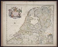
Beinecke Rare Book and Manuscript Library > A new mapp of the kingdome of England, representing the princedome of Wales, and other provinces, cities, market towns, with the roads from town to town and the number of reputed miles between them, are given by inspection without scale or compass
Creator:
Published / Created:
ca. 1684
Call Number:
Folio 469
Collection Title:
[Atlas factice of 13 maps by Nicolaes Visscher I, Nicolaes Visscher II, Guillaume Sanson, and
Image Count:
1
Publisher:
Nicolaes Visscher
Subject (Geographic):
Benelux countries --Maps --Early works to 1800 and Europe --Maps --Early works to 1800
Subject (Topic):
Atlases, Dutch --Early works to 1800
Collection Created:
1677-1692
Found in:
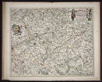
Beinecke Rare Book and Manuscript Library > Belgium Foederatum / [cartographic material] / emendate auctum et novissime editum, per Nicolaum Visscher
Creator:
Published / Created:
ca. 1684
Call Number:
Folio 469
Collection Title:
[Atlas factice of 13 maps by Nicolaes Visscher I, Nicolaes Visscher II, Guillaume Sanson, and
Image Count:
1
Publisher:
Nicolaes Visscher
Subject (Geographic):
Europe --Maps --Early works to 1800 and Hainaut (Belgium) --Maps --Early works to 1800
Subject (Topic):
Atlases, Dutch --Early works to 1800
Collection Created:
1677-1692
Found in:
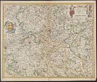
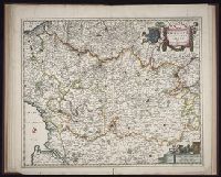
Beinecke Rare Book and Manuscript Library > Comitatus Hannoniae et Archiepiscopatus Cameracensis tabula / [cartographic material] / per Nicolaum Visscher
Creator:
Published / Created:
ca. 1684]
Call Number:
3371 1675
Container / Volume:
BRBL_00089
Image Count:
1
Resource Type:
Maps, Atlases & Globes
Description:
Bar scales given in "Milliaria Germanica communia" and "Milliaria Gallica communia"., Date inferred from C. Koeman's Atlantes Neerlandici, v. 3, p. 165 (Vis 10, map 7)., Prime meridian: Ferro., Relief shown pictorially., and Sheet measures 49.6 x 58.8
Publisher:
Nicolaes Visscher,
Subject (Geographic):
Hainaut (Belgium)--Maps--Early works to 1800
Found in:
Beinecke Rare Book and Manuscript Library > Comitatus Hannoniae et Archiepiscopatus Cameracensis tabula [cartographic material] / per Nicolaum Visscher.
Creator:
Published / Created:
ca. 1684
Call Number:
Folio 469
Collection Title:
[Atlas factice of 13 maps by Nicolaes Visscher I, Nicolaes Visscher II, Guillaume Sanson, and
Image Count:
1
Publisher:
Nicolaes Visscher
Subject (Geographic):
Europe --Maps --Early works to 1800 and Namur (County) --Maps --Early works to 1800
Subject (Topic):
Atlases, Dutch --Early works to 1800
Collection Created:
1677-1692
Found in:
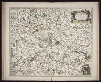
Beinecke Rare Book and Manuscript Library > Comitatus Namurci / [cartographic material] / emendata delineatio nuperrime in lucem edita per Nicolaum Visscher
Creator:
Published / Created:
ca. 1684
Call Number:
Folio 469
Collection Title:
[Atlas factice of 13 maps by Nicolaes Visscher I, Nicolaes Visscher II, Guillaume Sanson, and
Image Count:
2
Publisher:
Nicolaes Visscher
Subject (Geographic):
Europe --Maps --Early works to 1800 and Luxembourg --Maps --Early works to 1800
Subject (Topic):
Atlases, Dutch --Early works to 1800
Collection Created:
1677-1692
Found in:
Beinecke Rare Book and Manuscript Library > Ducatus Lutzenburgi novissima et accuratissima delineatio / [cartographic material] / per Nic. Visscher
Creator:
Published / Created:
1695?]
Call Number:
48 1695
Container / Volume:
BRBL_00262
Image Count:
1
Resource Type:
Maps, Atlases & Globes
Description:
"Cum privil ... " and Pictorial cartouche.
Subject (Geographic):
Greece--Maps--Early works to 1800
Found in:
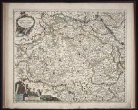
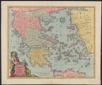
Beinecke Rare Book and Manuscript Library > Exactissima totius Archipelagi nec non Graeciae tabula : in qua omnes subjacentes regiones et insulae distincte ostenduntur / per Nicolaum Visscher, Amstelo-Batm.
Creator:
Published / Created:
ca. 1684
Call Number:
Folio 469
Collection Title:
[Atlas factice of 13 maps by Nicolaes Visscher I, Nicolaes Visscher II, Guillaume Sanson, and
Image Count:
1
Publisher:
Nicolaes Visscher
Subject (Geographic):
Belgium --Maps --Early works to 1800, Europe --Maps --Early works to 1800, and France, Northern --Maps --Early works to 1800
Subject (Topic):
Atlases, Dutch --Early works to 1800
Collection Created:
1677-1692
Found in:
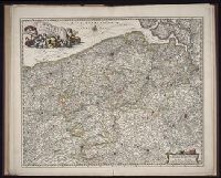
Beinecke Rare Book and Manuscript Library > Flandriae comitatus / [cartographic material] / accuratissima descriptio edita per Nicolaum Visscher
Creator:
Published / Created:
ca. 1684
Call Number:
Folio 469
Collection Title:
[Atlas factice of 13 maps by Nicolaes Visscher I, Nicolaes Visscher II, Guillaume Sanson, and
Image Count:
1
Publisher:
Nicolaes Visscher
Subject (Geographic):
Artois (France) --Maps --Early works to 1800, Europe --Maps --Early works to 1800, and Pas-de-Calais (France) --Maps --Early works to 1800
Subject (Topic):
Atlases, Dutch --Early works to 1800
Found in:
Beinecke Rare Book and Manuscript Library > Geographica Artesiae comitatus tabula / [cartographic material] / per Nicolaum Visscher edita
Creator:
Published / Created:
1704?]
Call Number:
3321 1704
Container / Volume:
BRBL_00081
Image Count:
1
Resource Type:
Maps, Atlases & Globes
Description:
Appears in Atlas major, sive Geographia recens, qua orbis terrarum per complures...
Publisher:
Ex officina Nicolai Visscher,
Subject (Geographic):
Groningen (Netherlands : Province)--Maps--Early works to 1800
Found in:
Beinecke Rare Book and Manuscript Library > Groningae et Omlandiae dominium vulgo de provincie van Stadt en lande / tabulam redactum per Lud Tjardae a ̀Starckenburg et Nicol Visscher.
Branch:v1.64.0 ,Deployed:2024-09-11T10:25:15-04:00