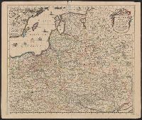
Regni Poloniae et Ducatus Lithvaniae Voliniae, Podoliae Vcraniae Prvssiae, Livoniae et Cvrlandiae descriptio
Description:
303 1660: Imperfect: lower left corner chipped, with no loss of text. Sheet measures 53.0 x 62.5 cm., Appears in various editions of Wit's Atlas., Bar scale given in "Duytsche Mylen.", Prime meridian: Ferro., Relief shown pictorially., and Variant giving westernmo
Publisher:
[Frederik de Wit,
Subject (Geographic):
Baltic States--Maps--Early works to 1800, Belarus--Maps--Early works to 1800, and Poland--Maps--Early works to 1800
Regni Poloniae et Ducatus Lithvaniae Voliniae, Podoliae Vcraniae Prvssiae, Livoniae et Cvrlandiae descriptio
Description:
Appears in various editio, Bar scale given in "Duytsche Mylen.", Prime meridian: Ferro., Relief shown pictorially., Sheet measures 52.2 x 61.6 cm., Variant giving westernmost longitude at 35 degrees and easternmost longitude at 63 degrees., and Watermark.
Publisher:
[Frederik de Wit,
Subject (Geographic):
Baltic States--Maps--Early works to 1800, Belarus--Maps--Early works to 1800, and Poland--Maps--Early works to 1800
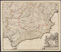
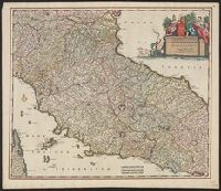
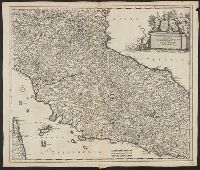
Appears in various editions of Wit's Atlas., Bar scales in "Milliaria Germanica communia 15 in uno gradu," "Milliaria Gallica magna, sive horae itineris,, Relief shown pictorially., and Sheet measures 53.3 x 62.1 cm. Ms. no. in upper right corner: 113.
Publisher:
Frederik de Wit?,
Subject (Geographic):
Tuscany (Grand Duchy)--Maps--Early works to 1800
Subject (Name):
Rodriguez, José M.--Bookplate and Wit, Frederik de. Atlas
Appears in various editions of Wit's Atlas., Bar scales in "Milliaria Germanica communia 15 in uno gradu," "Milliaria Gallica magna, sive horae itineris," and "mil, Relief shown pictorially., and Sheet measures 53.3 x 62.1 cm. Ms. no. in upper right corner: 113.
Publisher:
Frederik de Wit?,
Subject (Geographic):
Tuscany (Grand Duchy)--Maps--Early works to 1800
Subject (Name):
Rodriguez, José M.--Bookplate and Wit, Frederik de. Atlas
Appears in N. Vischer's Atlas minor sive geographia compendiosa, 1684., In lower right margin: Gedruckt t'Amsterdam by Frederick de Wit voor inde Calverstraet by den dam inde witte Pascaart., Map of Russian Far East, China and, and Sheet measures 45.5 x 56.5 cm.
Subject (Geographic):
China--Maps--Early works to 1800, Japan--Maps--Early works to 1800, and Russia (Federation)--Maps--Early works to 1800
Subject (Name):
L'Huilier, Joannes, engraver and Visscher, Nicolaes, 1649-1702. Atlas minor
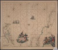
Terra Neuf, en de custen van Nieu Engeland, Nieu Nederland, Nieu Andalusia, Guiana en Venezuela
Description:
Covers the Atlantic Ocean west of the Azores and Cape Verde Islands, and the coasts of northeastern North America and northern South Amerca., Fr, In Latin and Dutch., Includes two decorative cartouches and ill., North oriented to left., and With "22" at top right.
Publisher:
Gedruckt by Fredrick de Wit in de Kalverstrae,
Subject (Geographic):
Atlantic Provinces--Maps--Early works to 1800 and North Atlantic Ocean--Maps--Early works to 1800
Subject (Name):
Wit, Frederik de. Orbis Maritimus ofte Zee Atlas
Subject (Topic):
Nautical charts--Atlantic Ocean--Early works to 1800
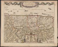
"20" in upper right corner., Along the top of the map is a garland supported by a cherubim; at bottom center, the encapment of the tribes flanked by Moses and Aaron is pictured., Appears in various editions of Wit's Atlas., Relief shown pictorially., and Sheet me
Publisher:
Gedruckt tot Amsterdam by Frederick de Wit in de Calverstraet by den Dam inde Witte Paskaert,
Subject (Geographic):
Palestine--History--To 70 A.D.--Maps and Palestine--Maps--Early works to 1800