Skip to search
Skip to main content
Skip to first result
Search
You Searched For
Extent of Digitization
Completely digitized
Genre
Cadastral maps
Search Results
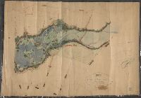
Creator:
Published / Created:
[1907]
Call Number:
771 H379 1907
Container / Volume:
BRBL_00482A
Image Count:
1
Resource Type:
Maps, Atlases & Globes
Description:
North oriented towards the left.
Subject (Geographic):
Oceanside (N.Y.)--Maps
Subject (Name):
Davison, Lewis. and Davison, Tredwell.
Subject (Topic):
Real property--New York (State)--Oceanside--Maps.
Found in:
Beinecke Rare Book and Manuscript Library > Map of Meadow Land at Ocean side in the town of Hempstead Nassau County, N.Y. belonging to the estate of Lewis Davison Dec'd and the estate of Tredwell Davison dec'd / surveyed in March 1907, by DS Denton, Jr.
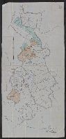
Creator:
Published / Created:
1912
Call Number:
802gbc P429 1912
Container / Volume:
BRBL_00717
Image Count:
1
Resource Type:
Maps, Atlases & Globes
Alternative Title:
Map of Riverside Coal and Timber Co.
Description:
Coordinates not present on map and are approximated.
Subject (Geographic):
Perry County (Ky.)--Maps
Subject (Name):
Riverside Coal & Timber Company
Subject (Topic):
Coal trade--Kentucky--Perry County--Maps and Real property--Kentucky--Perry County
Found in:
Beinecke Rare Book and Manuscript Library > Map of Riverside Coal & Timber Co. : lands on Little Leatherwood C'r, Perry Co., Kentucky / J.C. Heydrick.
Published / Created:
1889?]
Call Number:
846 W867 1889
Container / Volume:
BRBL_00622
Image Count:
2
Resource Type:
Maps, Atlases & Globes
Alternative Title:
Map and description of Woodstock
Description:
Date inferred from list of property prices, dated Dec. 12, 1889, attached to verso.
Publisher:
Telfer & Stearns?,
Subject (Geographic):
Woodstock (Or.)--Maps
Subject (Name):
Havely, J. C, Lewis & Dryden Printing Company, and Telfer & Stearns Real Estate Co
Subject (Topic):
Real property--Oregon--Woodstock--Maps
Found in:
Beinecke Rare Book and Manuscript Library > Map of Woodstock : the eastern terminus of the Waverly-Woodstock Electric motor line / J.C. Havely, trustee ; Telfer & Stearns Real Estate Co., general agents.
Published / Created:
[1859?] and [between 1880 and 1889?]
Call Number:
BrSides Folio 2018 138
Image Count:
1
Resource Type:
Maps, Atlases & Globes
Alternative Title:
Map of a portion of Point Keweenaw, Lake Superior
Description:
Backed with linen. Manuscript annotations on map. Manuscript title on verso: Copper Harbour & Eagle Harbour. From the Richard H. Rickard Papers.
Publisher:
[publisher not identified],
Subject (Geographic):
Keweenaw County (Mich.)--Maps. and Michigan--Keweenaw County
Subject (Name):
Delaware Mining Company of Michigan--Maps., Friend, Norman M., approximately 1815-, Pennsylvania Mining Company of Michigan--Maps., and Rickard, Richard H.,---1885--Ownership.
Subject (Topic):
Copper mines and mining, Copper mines and mining--Michigan--Keweenaw County--Maps., Landowners, Landowners--Michigan--Keweenaw County--Maps., Mines and mineral resources, and Mines and mineral resources--
Found in:
Beinecke Rare Book and Manuscript Library > Map of a portion of Point Keweenaw, L.S. : showing the lands &c. of the Pennsylvania & Delaware Mining Co's.
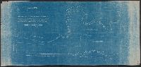
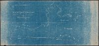
Creator:
Published / Created:
Decr. 1863.
Call Number:
Roll Map 78
Image Count:
2
Resource Type:
cartographic image
Alternative Title:
Map of a portion of Westville and New Haven
Description:
Imperfect: mutilated. Mounted on linen. Manuscript note on verso (partially trimmed): Map of old P[?]; D.G. Mitchell.
Subject (Geographic):
New Haven (Conn.)
Found in:
Beinecke Rare Book and Manuscript Library > Map of a portion of Westville & New Haven
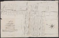
Published / Created:
[1834]
Call Number:
771 J222 1834
Container / Volume:
BRBL_00483
Image Count:
1
Resource Type:
Maps, Atlases & Globes
Publisher:
Stodart & Curriers Lithography,
Subject (Geographic):
Jamaica (New York, N.Y.)--Maps
Found in:
Beinecke Rare Book and Manuscript Library > Map of property at Jamaica belonging to Abrm. H. Van Wyck.
Published / Created:
1936
Call Number:
796 T247 1936
Container / Volume:
BRBL_00528
Image Count:
1
Resource Type:
Maps, Atlases & Globes
Alternative Title:
City of Temple, Texas and Temple, Texas
Description:
Cadastral map.
Publisher:
s.n.],
Subject (Geographic):
Temple (Tex.)--Maps
Subject (Topic):
Real property--Texas--Temple--Maps
Found in:
Beinecke Rare Book and Manuscript Library > Map of the city of Temple, Texas.
Published / Created:
ca. 1910?]
Call Number:
BrSides Elephant Folio 2010 22
Image Count:
2
Description:
Two maps on verso: New Artesia, Atascosa County, Texas, founded by Dr. Chas. F. Simmons, 1908 / S.L. Chalk, surveyor (Scale [ca. 1:2,400]); New Pleasanton, Atascosa County, Texas, founded by Dr. Chas. F. Simmons, 1908 / S.L. Chalk, surveyor (Scale [ca...
Publisher:
s.n.
Subject (Geographic):
Atascosa County (Tex.), Texas, and Atascosa County
Subject (Topic):
Real property
Found in:
Beinecke Rare Book and Manuscript Library > Map of the lands of Dr. Chas. F. Simmons as surveyed according to his plan of sale situated in Atascosa County, Texas. [cartographic material]
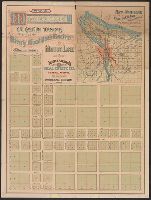
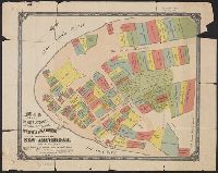
Creator:
Published / Created:
[approximately 1897?]
Call Number:
771 1897A
Container / Volume:
BRBL_00479
Image Count:
1
Resource Type:
Maps, Atlases & Globes
Alternative Title:
Old New York
Description:
Cadastral map showing property lots with dimensions, names of owners, and year of grant (1642-1658), and early roads.
Publisher:
[Dunreath Pub. Co.],
Subject (Geographic):
Manhattan (New York, N.Y.)--Maps
Subject (Name):
Dunreath Publishing Co
Subject (Topic):
Land grants--New York (State)--New York--Maps and Real property--New York (State)--New York--Maps
Found in:
Beinecke Rare Book and Manuscript Library > Map of the original grants of village lots from the Dutch West India Company to the inhabitants of New-Amsterdam (now New-York) lying below the present line of Wall Street : grants commencing A.D. 1642 / [by Henry Dunreath Tyler].